Unda is a team of highly experienced flood risk consultants holding more than 50 years’ combined experience in conducting flood risk reports. With years working closely with the Environment Agency, Natural Resources Wales, Local Planning Authorities, Water Authorities, Lead Local Flood Authorities and insurance providers, we provide assessments to help you understand the risk of flooding of your site, property or premises.
What is a Flood Risk Assessment (FRA)?
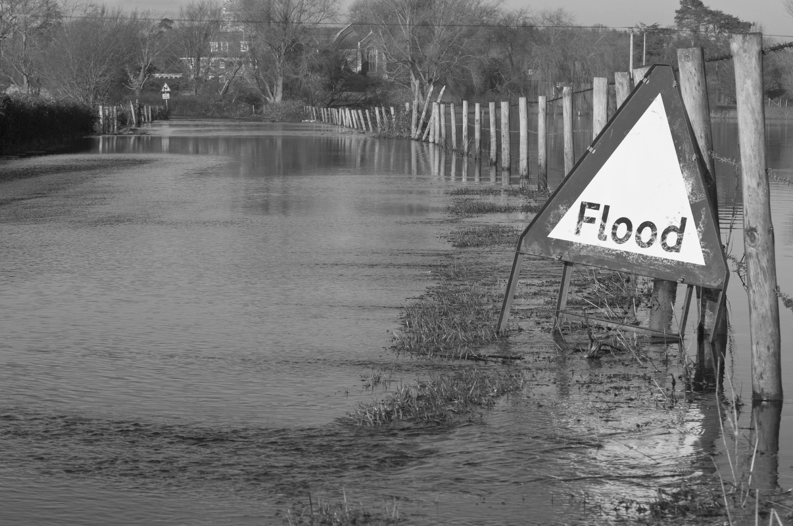
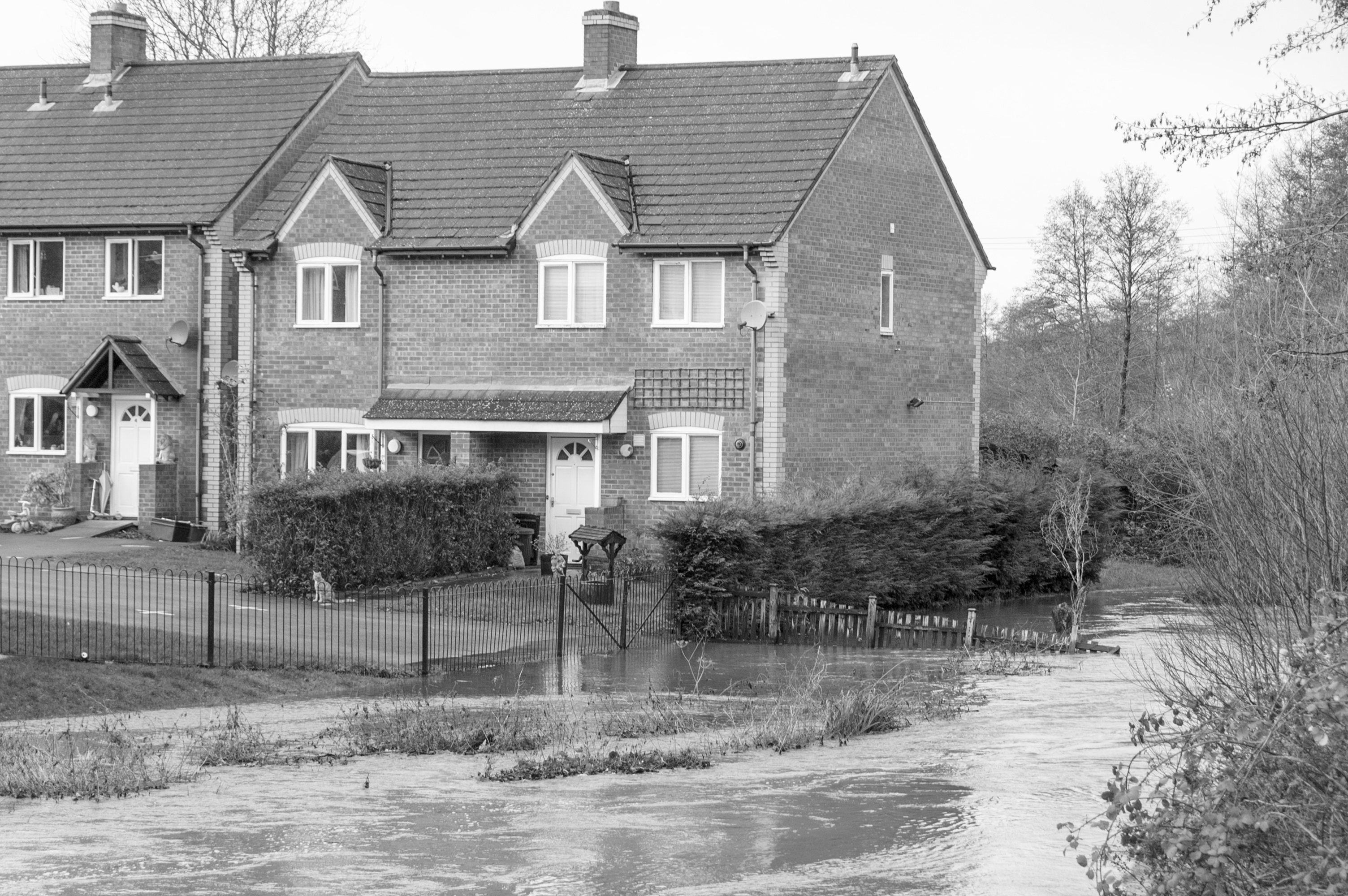
An FRA identifies the level of flood risk to your property or site from all sources of flooding, and identifies the measures necessary (if any) to make the property or site safe in flood risk terms.
When do you need a FRA?
A FRA will be required for planning for most development within a flood risk area, as defined by the Environment Agency Flood Zones or the Development Advice Map in Wales, if the Local Planning Authority is concerned about the risk from surface water flooding or if there are critical drainage problems. This type of report can also be required for environmental accreditation such as BREEAM.
One may also be required for insurance if the site or property has flooded previously, or if the insurance companies flood data shows the area to be at risk of flooding, as part of a property purchase or for due diligence / Business Continuity Management.
When do you need a FRA for planning?
There are a number of instances in which this kind of report is a requirement when submitting a planning application.
In England one is required for most developments within one of the EA Flood Zones, which includes developments:
- in flood zone 2 or 3 including minor development and change of use
- more than 1 hectare (ha) in flood zone 1
- less than 1 ha in flood zone 1, including a change of use in development type to a more vulnerable class (for example from commercial to residential), where they could be affected by sources of flooding other than rivers and the sea (for example surface water drains, reservoirs)
- in an area within flood zone 1 which has critical drainage problems as notified by the Environment Agency
In Wales, the Development Advice Maps (DAM) are used to determine when flood risk issues need to be taken into account in planning future development. The maps are based on the EA’s extreme flood outlines (zone C) and the BGS drift data (zone B) and are used to determine when a Flood Consequence Assessment (FCA) will be required.
When do you not need one for planning?
You don’t need this kind of report for a development that’s less than 1 hectare in Flood Zone 1 unless it could be affected by sources of flooding other than rivers and the sea (such as those identified by the Local Planning Authority), for example surface water or groundwater.
What is included in the report?
Our reports are written and created specifically to the needs of each client. Our friendly experienced team will guide you through the process if you have not commissioned a report before. If you have experience in this kind of report you will find our team knowledgeable and easy to deal with.
The objectives of a FRA are to establish whether the proposed development is likely to be affected by current or future flooding from any source; whether it will increase flood risk elsewhere and whether the measures proposed to deal with these effects and risks are appropriate.
To carry out this kind of report a review of relevant flood information and data (from the EA, NRW or the Local Planning Authority) is required, including details about the level of flood protection and consultation to define the specific flood risk issues/considerations associated with the site and any potential development.
A review of local flood risk documents such as Strategic Flood Risk Assessment (SFRA), Surface Water Management Plan, and any relevant flood modelling and historical records contained within (if available) is also required.
The report must identify flood risk issues and constraints associated with the proposed development within the floodplain and identify flood mitigation options.
Unda will liaise with the project team and architect with regard to finished floor and threshold levels, and other flood resistant building techniques, and produce a final written report in a clear and concise style to support the application at the site, for submission with your planning application.
Depending on the flood risk, assessments can be as simple as a short written statement, or may need complex detailed hydraulic flood modelling. The level of risk will depend on the type of development, the size of site and its location in relation to flood risk areas and also the amount of surface water runoff the site will discharge.
It is important to know that this kind of report is development and planning application specific so one must be done for each application if applicable.
Flood Risk and the Planning Process
We have years of experience with the Environment Agency as well as the Scottish Environment Protection Agency, National Resources Wales and the Rivers Agency in Northern Ireland. We also deal directly with your local planning authority to make sure we include the detailed requirements they set down too.
Flood Legislation
The National Planning Policy Framework (NPPF) sets strict guidelines to protect people and property from flooding which all local planning authorities should follow.
For the purposes of applying the National Planning Policy Framework, “flood risk” is a combination of the probability and the potential consequences of flooding from all sources – including from rivers and the sea, directly from rainfall on the ground surface and rising groundwater, overwhelmed sewers and drainage systems, and from reservoirs, canals and lakes and other artificial sources (Planning Practice Guidance, Flood risk and coastal change (https://www.gov.uk/guidance/flood-risk-and-coastal-change)).
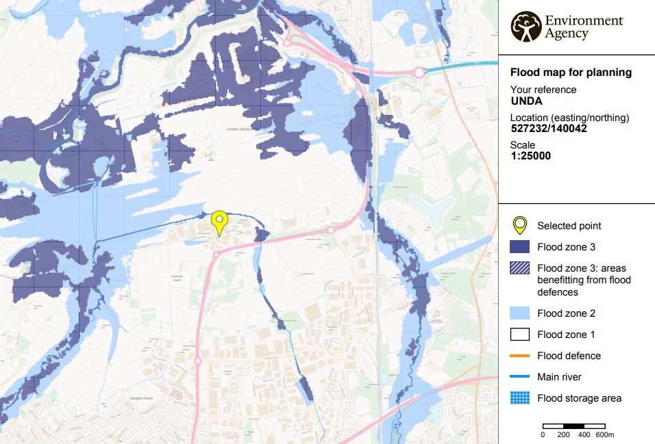
For the purposes of applying the National Planning Policy Framework, areas at risk from all sources of flooding are included. For fluvial (river) and sea flooding, this is principally land within Flood Zones 2 and 3. It can also include an area within Flood Zone 1 which the Environment Agency has notified the local planning authority as having critical drainage problems (Planning Practice Guidance, Flood risk and coastal change).
| Flood Zone | Definition |
| Zone 1 Low Probability | Land having a less than 1 in 1,000 annual probability of river or sea flooding. (Shown as ‘clear’ on the Flood Map – all land outside Zones 2 and 3) |
| Zone 2 Medium Probability | Land having between a 1 in 100 and 1 in 1,000 annual probability of river flooding; or land having between a 1 in 200 and 1 in 1,000 annual probability of sea flooding. (Land shown in light blue on the Flood Map) |
| Zone 3a High Probability | Land having a 1 in 100 or greater annual probability of river flooding; or Land having a 1 in 200 or greater annual probability of sea flooding.(Land shown in dark blue on the Flood Map) |
| Zone 3b The Functional Floodplain | This zone comprises land where water has to flow or be stored in times of flood. Local planning authorities should identify in their Strategic Flood Risk Assessments areas of functional floodplain and its boundaries accordingly, in agreement with the Environment Agency. (Not separately distinguished from Zone 3a on the Flood Map) |
Call For Your Free Quote Now

If you need a quote or to discuss your requirements in more detail contact Jackie Stone, one of our experienced Flood Risk Consultants.
Call 01293 214444
Email enquiries@unda.co.uk
Or Fill Out The Form Below
Areas we cover:
Our team have produced Flood Risk Assessment reports for clients across the UK, including Berkshire, Cambridgeshire, Cheshire, Sussex, Cornwall, Elmbridge, Croydon, Devon, Hampshire, Kent, Greater London, Oxfordshire and North and South Yorkshire in England as well as Wales and Scotland.
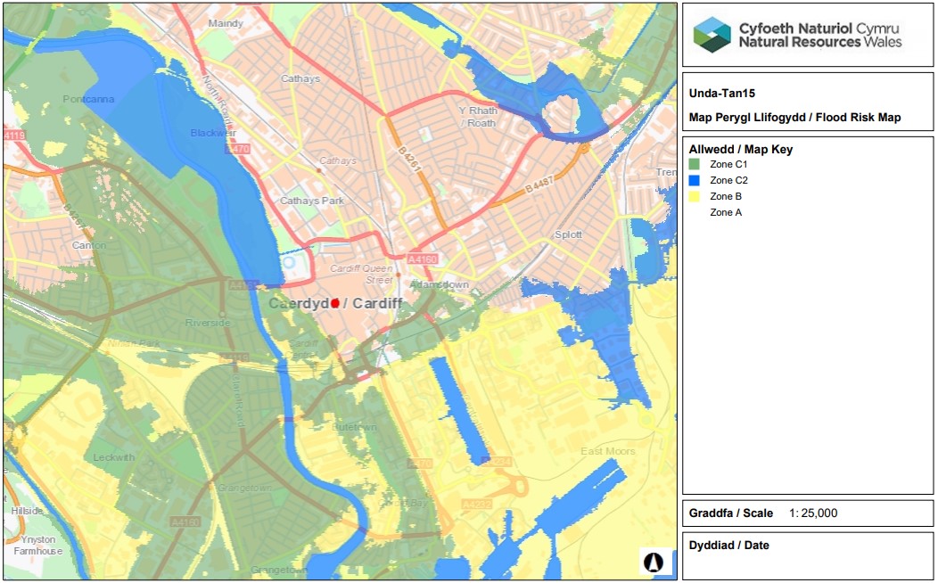
TAN15
https://beta.gov.wales/technical-advice-note-tan-15-development-and-flood-risk
The general approach of Planning Policy Wales, supported by the TAN, is to advise caution in respect of new development in areas at high risk of flooding by setting out a precautionary framework to guide planning decisions.
The Development Advice Maps (DAM) are used to determine when flood risk issues need to be taken into account in planning future development. The maps are based on the EA’s extreme flood outlines (zone C) and the BGS drift data (zone B) and are used to determine when a Flood Consequence Assessment (FCA) will be required.
| Zone | Description of Zone |
| A | Considered to be at little or no risk of fluvial or tidal/coastal flooding. |
| B | Areas known to have been flooded in the past evidenced by sedimentary deposits. |
| C | Based on Environment Agency extreme flood outline, equal to or greater than 0.1% (river, tidal or coastal). |
| C1 | Areas of the floodplain which are developed and served by significant infrastructure, including flood defences. |
| C2 | Areas of the floodplain without significant flood defence infrastructure. |
Local Planning Authority Requirements – e.g. Elmbridge, Harrow and Croydon
Some Local Planning Authorities are particularly concerned about localised flooding from surface water generated by heavy rainfall, elevated groundwater, existing drainage systems as well as artificial sources including several reservoirs.
The pressure for development is high and it is important that the implications of flood risk are taken into account.
A Flood Risk Assessment can be required when a site has been identified as at risk from surface water flooding or other localised flooding by the LPA. Flood Risk Supplementary Planning Documents, Local Flood Risk Management Strategies, Core Strategy Policies and the Local Plan (for example in Croydon, Elmbridge and Harrow) provides guidance to assist applicants in when a FRA will be necessary and what information will be required to support an application.
FAQs
- A Flood Risk Assessment identifies the level of flood risk to your property or site from all sources of flooding, and identifies the measures necessary (if any) to make the property or site safe in flood risk terms.
- A FRA will be required for planning for most development within a flood risk area, as defined by the Environment Agency Flood Zones or the Development Advice Map in Wales, if the Local Planning Authority is concerned about the risk from surface water flooding or if there are critical drainage problems. A FRA can also be required for environmental accreditations such as BREEAM.
- A FRA may also be required for insurance if the site or property has flooded previously, or if the insurance companies flood data shows the area to be at risk of flooding, as part of a property purchase or for due diligence / Business Continuity Management.
- One of the key requirements of the Flood Risk Assessment process is to demonstrate that proposals will not increase flood risk elsewhere. Surface water runoff from the site must therefore be appropriately managed. A drainage strategy may be requested by the Local Planning Authority for any site (including small sites outside of the river/sea floodplain) to demonstrate how runoff from the new development will be managed.
- A surface water drainage strategy outlines how surface water discharge (runoff) from the development will be managed, to comply with the requirements of the NPPF.
- The Drainage Strategy will make an assessment of all available surface water drainage options for the development site, whilst demonstrating that the rate of surface water discharge (runoff) will not exceed the existing site conditions.
- A drainage strategy may be requested by the Local Planning Authority for any site (including sites outside of the river/coastal floodplain) to demonstrate how runoff from the new development will be considered.
- The Environment Agency Flood Zones have been produced in part by using a national scale flood model known as JFLOW. JFLOW has been used to produce the 1% (1 in 100 year) and 0.1% (1 in 1000 year) flood outlines. Where more detailed flood modelling has been undertaken, then this flood data is used to update the Flood Zone outlines.
- The EA Flood Zones (Flood Map for Planning) is updated on a quarterly basis.
- The EA acknowledges that the JFLOW method is generalised and does not take flood defences or other local information into consideration. As such, the flood outlines produced by JFLOW can only be taken as a rough guide, showing where more detailed flood risk assessments are required.
- These Flood Zones refer to the probability of river and sea flooding, ignoring the presence of defences. The NPPF requires the flood risk without the presence of flood defences to be assessed as areas behind flood defences are at particular risk from rapid onset of fast-flowing and deep water flooding, with little or no warning if defences are overtopped or breached.
- The Flood risk from rivers or the sea flood maps have been generated from the National Flood Risk Assessment (NaFRA) dataset, which has been used to classify flood risk into high, medium, low and very low. This takes into account the location, type and condition of local flood defences, and is not a dataset suitable for planning.
- The Flood Map for planning defines the Flood Zones, which refer to the probability of river and sea flooding, ignoring the presence of defences.
- If the Environment Agency has not carried out detailed flood modelling for a river or other watercourse, then no modelled flood levels, depths or extents are available for a FRA. Without modelled flood levels available to determine the potential depth of flooding on site, the implications of this for the development cannot be accurately determined.
- The EA / Council may request detailed hydraulic modelling to be undertaken to assess the risk of flooding and the impact of climate change. Where this is proportional to the scale of the development we regularly construct flood models to estimate flood levels.
- We can begin work immediately following instruction, and can usually provide the completed report within 1-2 weeks following receipt of EA flood data.
- The EA as a government body have a statutory 20 working day turnaround time. In many cases however we hold the data in house. Should you require a report sooner in order to meet a planning deadline, we would be able to produce an interim report to allow your planning application to be validated. We would then issue you an updated report once we had received and analysed the EA flood data.
- A Flood Risk Assessment (FRA) report can be simple and straightforward and cost as little as a few hundred pounds. Depending on the flood risk, FRAs can be as simple as a short written statement, or may need complex detailed hydraulic flood modelling. The level of risk will depend on the type of development, the size of site and its location in relation to flood plain areas and also the amount of surface water runoff the site will discharge.
- We provide competitive fixed fee no obligation quotations.
- A FRA will be required for planning for most development within a flood risk area, as defined by the Environment Agency Flood Zones, including for minor development and change of use.
- The Environment Agency has provided standing advice if you’re carrying out a flood risk assessment for a development classed as minor extension (household extensions or non-domestic extensions less than 250 square metres) in flood zone 2 or 3
- You also need to follow standing advice for developments involving a change of use.
- The NPPF states that applications for some minor development and changes of use should not be subject to the sequential or exception tests but should still meet the requirements for site-specific flood risk assessments.
- The Planning Practice Guidance states that to help determine whether prior approval is required for a change of use of agricultural buildings, or a change from office to dwelling houses in an area at risk of flooding (under Permitted Development), an assessment of flood risk should be provided. This should demonstrate how the flood risks to the development will be managed so that it remains safe through its lifetime.
- The Flood Zones shown on the Environment Agency’s Flood Map for Planning (Rivers and Sea) do not take account of the possible impacts of climate change and consequent changes in the future probability of flooding.
- The NPPF sets out how the planning system should help minimise vulnerability and provide resilience to the impacts of climate change. A FRA should demonstrate how flood risk will be managed now and over the development’s lifetime, taking climate change into account.
- The EA has provided advice on climate change allowances to support the NPPF, which should be used for FRAs (https://www.gov.uk/guidance/flood-risk-assessments-climate-change-allowances)
- Sustainable Drainage Systems (SuDS) aim to mimic natural drainage by attenuating (storing and releasing slowly) runoff, allowing it to soak into the ground, slowly conveying water on the surface, filtering out pollutants, and allowing sediments to settle out by controlling the flow of water.
- Sustainable drainage is a change from the more traditional approach to drainage sites (pipes and culverts).
- Under the NPPF, development must not increase flood risk elsewhere (i.e. flood risk off-site). When plans include an increase in built footprint or land raising within the flood plain, then this could reduce the flood storage capacity of the site – and thereby increase flood risk off-site.
- Compensatory flood storage is the replacement of volumes lost from the flood plain through development with new flood plain volume by reducing nearby ground levels, at the same level at which it is lost.
- Where flood plain compensation is not possible other solutions such a floodable voids or undercroft car parking may need to be utilised, such that flood risk is not increase off-site.
- Under the NPPF, wherever possible, safe access routes should be provided that are located above design flood levels and avoiding flow paths. Where this is not possible, limited depths of flooding may be acceptable, depending on how fast the water is moving.
- Access and egress must be designed to be functional for changing circumstances over the lifetime of the development
- The NPPF states that development should be located as far as possible where there is the lowest risk of flooding. Development can be made safe by for example raising of floor levels above flood levels. It is sometimes necessary to raise the finished floor levels of new development to meet these requirements.
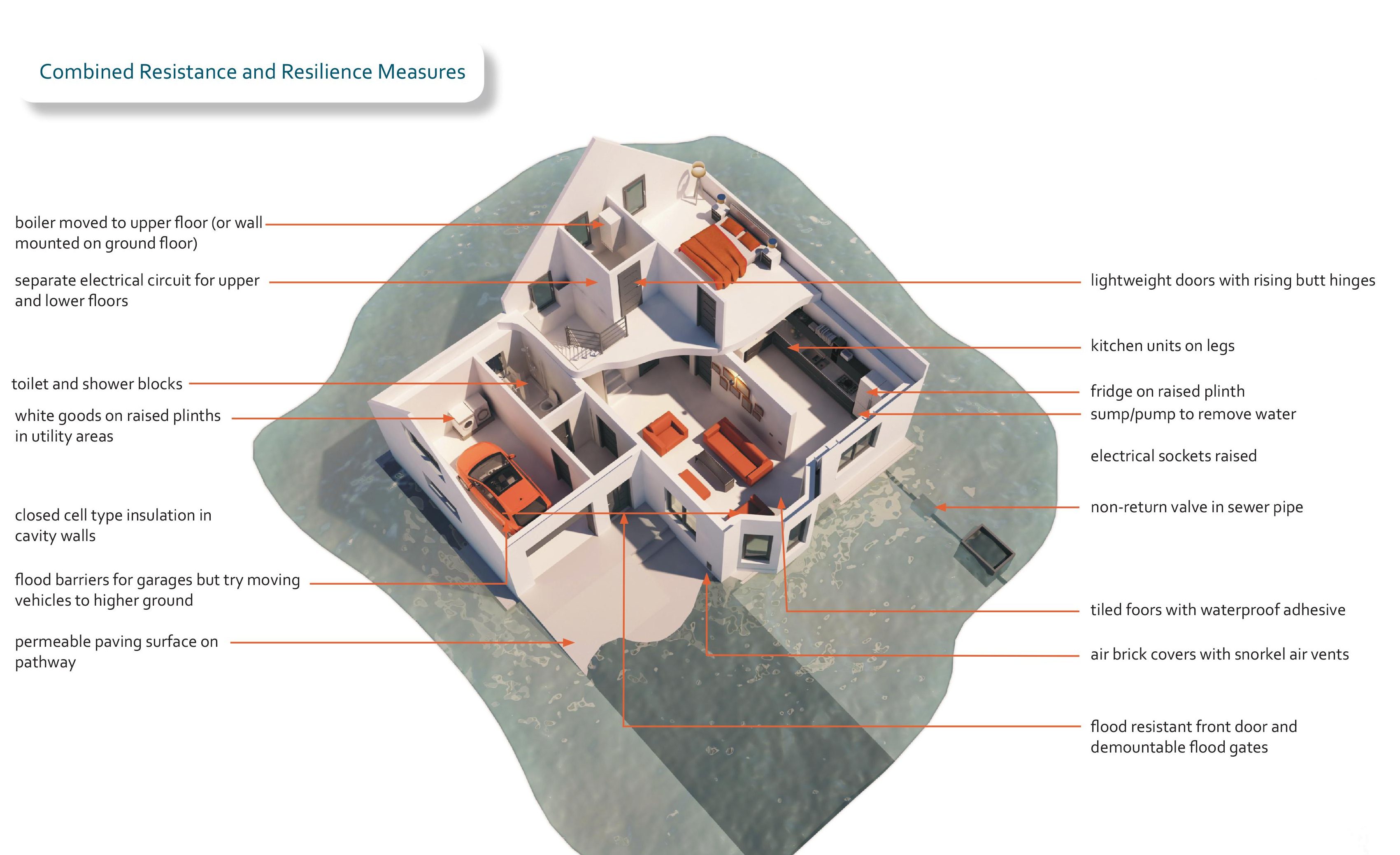
- Resistance and resilience measures are unlikely to be suitable as the only mitigation measure to manage flood risk, but they may be suitable in some circumstances to manage the risk of flooding where it cannot be removed.
- The operation of any mitigation measures should be safeguarded and maintained effectively through the lifetime of the development.
- When predicted flood depths are low (~0.3m) a water exclusion strategy is recommended, aiming to minimise water entry into the building.
- Where predicted flood depths are deeper (~0.6m or more) a water entry strategy is recommended, allowing water into the building, but facilitation drainage and drying.
- Improving the Flood Performance of New Buildings (Flood Resilient Construction) https://assets.publishing.service.gov.uk/government/uploads/system/uploads/attachment_data/file/7730/flood_performance.pdf
- The Sequential Test ensures new development is steered to areas with the lowest probability of flooding. The flood zones provide the basis for applying the Test. The aim is to steer new development to Flood Zone 1 (areas with a low probability of river or sea flooding). Where there are no reasonably available sites in Flood Zone 1, local planning authorities consider reasonably available sites in Flood Zone 2 (areas with a medium probability of river or sea flooding), applying the Exception Test if required. Only where there are no reasonably available sites in Flood Zones 1 or 2 should the suitability of sites in Flood Zone 3 (areas with a high probability of river or sea flooding) be considered, applying the Exception Test if required.
- The Exception Test is a method to ensure that flood risk to people and property will be managed satisfactorily, while allowing necessary development to go ahead in situations where suitable sites at lower risk of flooding are not available.
- For the exception test to be passed it should be demonstrated that:
- the development would provide wider sustainability benefits to the community that outweigh the flood risk; and
- the development will be safe for its lifetime taking account of the vulnerability of its users, without increasing flood risk elsewhere, and, where possible, will reduce flood risk overall.
- Both elements of the exception test should be satisfied for development to be allocated or permitted.