Planning is falling behind flood risk, says Aviva
Estimated reading time 7 minutes
Aviva’s Building future communities analysis presents a stark assessment of flood risk in England. By the middle of the century, millions more properties could be exposed to flooding, with risk increasingly driven by surface water flooding rather than rivers or the coast. The figures are striking, but the more important story lies behind them. What the analysis ultimately reveals is a growing misalignment between flood risk evidence and the way planning decisions continue to be made.
This is no longer a debate about whether flood risk is increasing. That point is settled. The more difficult question is whether the planning system is structured to respond to that risk in a way that is robust, consistent and defensible over the lifetime of development.
As Jackie Stone, Director and Consultant at Unda, observes: “The problem is no longer a lack of flood risk evidence. It is the way that evidence is absorbed – or sidelined – once sites move from allocation into delivery. Too often, flood risk becomes something to be mitigated later rather than a constraint that genuinely shapes decisions at the outset.”
Flood risk is becoming a mainstream planning constraint
Aviva estimates that by mid-century around 8 million properties in England could be at risk of flooding, an increase of approximately 25 – 27% compared with today. Expressed differently, around one in four homes could face some degree of flood risk within a few decades.
These figures are scenario-based rather than site-specific predictions, a point Aviva is careful to emphasise. Their importance lies in scale rather than precision. Flood risk is no longer a marginal issue confined to clearly defined floodplains. It is becoming a mainstream constraint affecting housing delivery, land allocation, development viability, infrastructure capacity and long-term occupation.
As exposure increases, flood risk is affecting sites that would historically have been considered low or moderate risk, particularly in urban and suburban areas. This challenges a planning framework that still focuses heavily on fluvial and coastal flooding, rather than the cumulative impacts of urbanisation and drainage capacity.
Surface water flooding is now the dominant risk
The most consequential finding in Aviva’s analysis is not simply the growth in flood exposure, but where that growth is coming from. Surface water flooding is identified as the fastest-growing source of flood risk, overtaking river and coastal flooding in many locations.
Critically, Aviva estimates that around 83% of properties exposed to surface water flooding are currently unprotected. Unlike fluvial flood risk, surface water flooding does not sit neatly within mapped flood zones that typically inform land allocation and policy tests. Instead, it is highly sensitive to impermeable surfaces, drainage design, maintenance regimes and the cumulative effects of development.
In practice, this means surface water risk is often addressed late in the planning process, through drainage strategies, planning conditions and post-permission approvals. Responsibility is fragmented between planning authorities, lead local flood authorities, highways bodies and water companies, with long-term maintenance frequently assumed rather than secured. The result is a widening gap between where flood risk is emerging and where planning control is strongest.

Flood risk policy exists – but outcomes tell a different story
England’s flood risk planning policy is extensive. Sequential and Exception Tests are embedded in national policy and supported by detailed guidance. However, Aviva’s retrospective analysis highlights a persistent gap between policy intent and delivery outcomes.
The analysis notes that around 110,000 homes have been built in the highest flood risk areas in England over the last decade, equivalent to approximately one in thirteen new homes. This is not a projection or a worst-case scenario – it is a record of what has already been delivered.
This does not imply that all such development is inappropriate. However, it does demonstrate how frequently flood risk policy is stretched under delivery pressure. Sequential and Exception Tests can become exercises in justification rather than genuine avoidance, with mitigation measures relied upon to render marginal sites acceptable. Taken cumulatively, this approach is embedding long-term exposure that will be difficult and costly to manage over the lifetime of development.
Jackie notes that this tension is increasingly visible in day-to-day planning outcomes: “Sequential and Exception Tests were designed to steer development away from the highest risk locations. In practice, they are now often used to justify why development should proceed regardless. That shift has long-term consequences for resilience, insurability and public confidence in the planning system.”
Flood risk data at a glance
The table below summarises the most planning-relevant flood risk data from Aviva’s analysis for England. These figures indicate direction and scale rather than precise forecasts.
| Flood risk indicator | Current position | Projected position (mid-century) | Change | Planning relevance |
| Properties at flood risk (all sources) | ~6.4 million | ~8.0 million | +25 – 27% | Flood risk is a mainstream planning issue |
| Proportion of homes at flood risk | ~1 in 5 | ~1 in 4 | Significant increase | Exposure is no longer exceptional |
| Surface water flood exposure | Widespread, unevenly managed | Rapid growth | ~83% unprotected | Drainage and governance drive risk |
| New homes built in highest flood risk areas (last decade) | n/a | ~110,000 homes | ~1 in 13 new homes | Policy intent not reflected in outcomes |
Aviva is clear that different datasets and climate scenarios underpin this analysis and that projections should not be applied mechanically at site level. That caveat is important, but it does not undermine the core planning challenge the data reveals.
Flood adaptation is still treated as negotiable
A striking feature of Aviva’s analysis is how modest many effective flood adaptation measures are, particularly when incorporated at design stage. Aviva suggests that property flood resilience measures could be included in new homes for around £1,000 per dwelling, while Flood Re’s Build Back Better scheme allows for up to £10,000 to support resilient reinstatement after flooding.
Exact costs will vary by site and specification, but the principle is clear. Designing for flood resilience upfront is cheaper, less disruptive and lower-carbon than repeated damage, repair and retrofit. Despite this, flood resilience is still often treated as negotiable, vulnerable to value engineering or deferred through planning conditions rather than embedded as a baseline requirement.
Flood maps highlight a governance gap
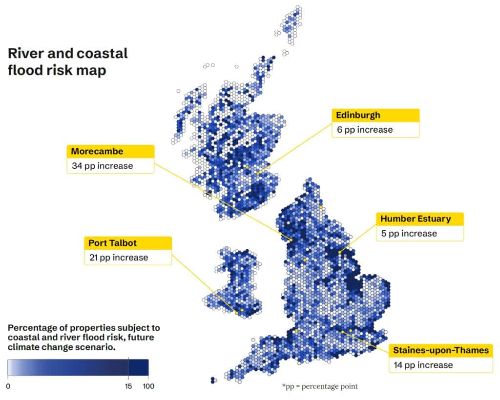
Aviva’s flood risk maps are visually compelling, but the analysis is careful about their limitations. They are scenario-based, use different methodologies and apply thresholds that make them unsuitable for site-specific decision-making.
Their real value lies in what they reveal about governance. Flood risk – particularly surface water flooding – is expanding into places where responsibilities are fragmented and long-term management is unclear. The consequences of planning decisions, including insurability, mortgageability and repeated disruption, often emerge decades after permission is granted.
Recent disruption caused by delays to national flood risk mapping updates has already shown how dependent planning decision-making has become on timely, authoritative data – and how fragile that process can be when evidence shifts.
Flood resilience must be treated as a core planning constraint
Read carefully, Aviva’s analysis is not a warning about some distant future. It is a judgement on present-day planning practice.
Flood risk in England is no longer confined to obvious floodplains. It is increasingly shaped by surface water, drainage capacity and cumulative development patterns. That reality places far greater weight on early-stage Flood Risk Assessment, on robust drainage and SuDS design, and on whether Sequential and Exception Tests are applied as genuine decision-making tools rather than post-hoc justifications.
As exposure grows, the consequences of getting this wrong become harder to manage later. Poorly resolved flood risk does not stay on paper – it reappears as delayed applications, contested conditions, redesign, retrofit, insurance difficulty and long-term disruption to occupiers. By contrast, schemes that interrogate flood risk, drainage strategy and site sequencing properly at the outset are better able to withstand scrutiny, adapt to updated evidence and remain viable over the lifetime of development.
The evidence now points clearly in one direction. Flood resilience can no longer be treated as an inconvenience to be managed away. It has become a defining constraint on how, where and whether development can proceed.
Read the full report, here:
Latest news






One of our experienced Flood Risk Consultants will get back to you within 60 minutes
