Does Glastonbury flood? Why Worthy Farm turns to mud
Estimated reading time 14 minutes
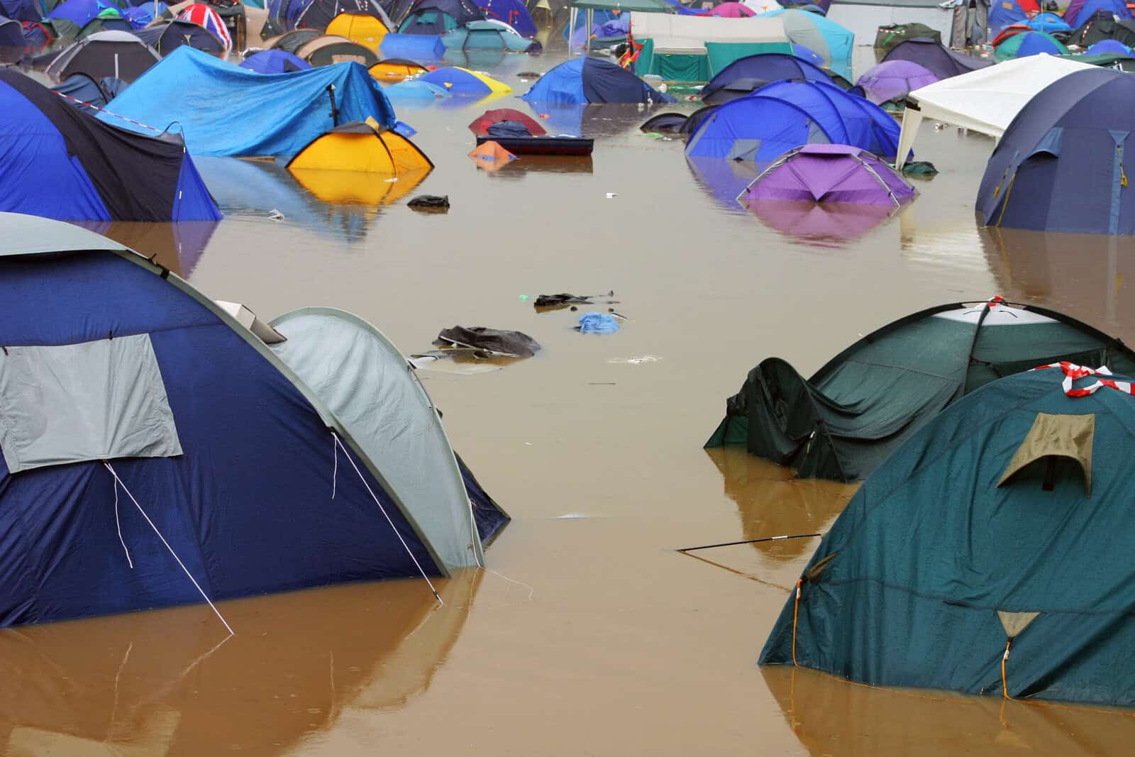
Does Glastonbury flood? Yes, though almost never because a river burst its banks. Worthy Farm sits in a shallow valley on clay with a watercourse through the middle, and what turns the site to mud is rain arriving faster than ground compacted by 200,000 pairs of boots can take it. That is surface water flooding, and it works the same way in every festival field in Britain.
We are flood risk consultants. We spend the working week telling developers where water will go when it rains, so what follows is our version of a festival survival guide: how festival flooding actually happens, our flood maps of three well-known sites, and where not to put your tent.
On Saturday 29 August 2026 the Met Office warned of 15 to 25 millimetres of rain in an hour across southern England and the Midlands. Ground compacted by three days of walking sheds nearly all of it.
Does Glastonbury flood?
Yes, but from surface water rather than from the Whitelake River that runs through it. Worthy Farm sits in a shallow valley near Pilton on slow-draining clay, so heavy rain collects and travels across the ground instead of soaking into it. That combination produced the festival's wettest and muddiest years, in 1997, 2005 and 2016. The site has never been flooded by the Whitelake in the way people picture; it is the rain landing on it that does the damage.
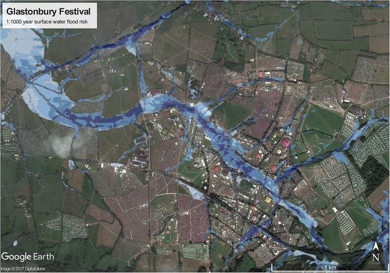
The map above is the Risk of Flooding from Surface Water dataset, the same layer we read on every flood risk assessment for a development site. Its blue paths are not puddles. They are the overland flow routes water takes downhill once the ground has stopped accepting it, and at Worthy Farm several of them converge on ground a lot of people end up camping on.
There was no festival in 2026. Worthy Farm took its fallow year, and the ground itself was part of the reason: a season without trampling lets soil structure recover, so the field absorbs more and sheds less when the crowd returns. Emily Eavis was blunt about it when the break was announced: "you lay the ground to rest and you come back stronger". Glastonbury returns on 23 to 27 June 2027.
Why any festival field floods
Festival fields flood because the ground stops working. Walking closes the pore space that rain drains through, and a field that soaked up a shower on Tuesday behaves like a car park by Friday night. Nothing about the rainfall has changed. The surface receiving it has.
In one trampling study, saturated infiltration on grassland fell from 2 to 2.5 centimetres an hour to 0.3 centimetres an hour, a loss of roughly 85 per cent.
That measurement comes from grazing research rather than from a campsite, and cattle are not festival-goers. It is the closest published analogue we have, and the direction is not in doubt: compaction cuts the infiltration rate at which ground can take water, and everything the ground cannot take runs off.
Three things then stack up:
- Compacted topsoil. Trampling collapses the structure water needs to drain through, so the permeability of the surface falls away over the first two days.
- Convective summer rain. Warm air holds more moisture, and summer storms are convective, which means they can drop a month of rain on one parish in an hour rather than spreading it over a week. That is what produces a flash flood on ground that cannot take it, and why a Met Office thunderstorm warning matters more to a campsite than a monthly outlook does.
- Low ground. Water that cannot soak in follows the slope and stops at the lowest point it can reach, which is where the tents are pitched most tightly.
None of that is river flooding. It is surface water flooding, or pluvial flooding in drainage language, and it is now the dominant source of urban flood risk in England. A festival field is a concentrated version of a national problem, and UK rainfall is getting more intense.
Reading Festival: a stage on a floodplain
Reading is the most honest of the three sites. Little John's Farm sits on the bank of the Thames just upstream of the Kennet confluence, which makes it floodplain, plainly. In a wet winter parts of it are underwater, which matters very little, because nobody camps there in January.
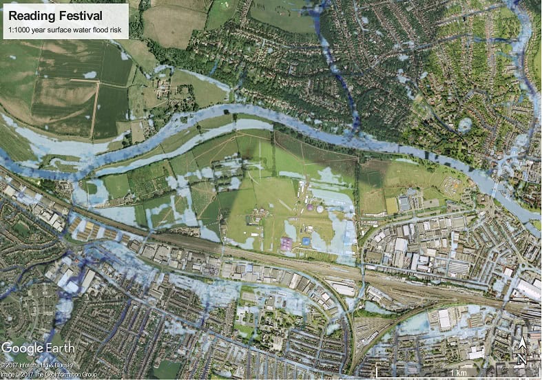
What the map shows at Reading
Flat riverside ground has nowhere to send a sudden downpour, so the risk collects in the corners rather than spreading.
- Winter is the river. The Thames and the Kennet drive the risk between November and March, when nobody is on site.
- August is the sky. Late summer risk is surface water, pooling in the low corners the map picks out.
- Height beats distance. A longer walk to the arena buys a drier tent.
By late August the river risk is low and the surface water risk is not, and the 2026 festival made the point without any help from us. A yellow thunderstorm warning was in force across south-west England, parts of Wales, the Midlands and eastern England until 9pm on Saturday 29 August, with the Met Office forecasting 15 to 25 millimetres in an hour and 30 millimetres over two to three hours. Reading and Leeds both caught it. Parts of Richfield Avenue turned to mud.
The advice writes itself: camp on the higher ground, away from the river edge and out of the dips, and treat the longer walk to the arena as the price of a dry sleeping bag.
Hylands Park: V Festival's old ground, State Fayre's new home
We first drew this map when Hylands Park hosted V Festival. V Festival ended in 2017, but the park outlived it. Creamfields South ran here in 2022 and 2023, and State Fayre arrived on 26 to 28 June 2026 with Kings of Leon, Neil Young and The Lumineers.
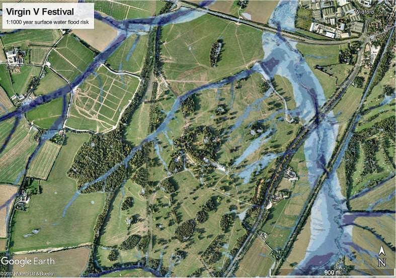
The flood risk did not leave with the headliners. This is a map of the park rather than of any event on it, and water still gathers in the same low spots and around the same ponds it always did. Ground behaves the way its levels and its soil tell it to, and neither of those changed when the branding did.
What the 2026 festival season actually did
The 2026 season tested every claim on this page. One site rested, one opened for the first time, and one got the rain.
| Site | 2026 season | 2027 |
|---|---|---|
| Worthy Farm, Pilton | Fallow year. No festival, and a season for the ground to recover | Glastonbury, 23 to 27 June |
| Hylands Park, Chelmsford | State Fayre, 26 to 28 June, the first event on the site since Creamfields South in 2023 | Not yet announced |
| Little John's Farm, Reading | Reading Festival, 27 to 30 August. Thunderstorm warning on the Saturday; parts of the site turned to mud | Reading and Leeds, 26 to 29 August |
The Reading weekend is the useful case, because it was not a named storm and it did not need to be. A thunderstorm warning on an August Saturday put enough water on compacted ground to turn parts of a working festival site into mud. A surface water map anticipates that. A weather forecast, on its own, does not.
What a festival site has to prove about flood risk, and what it does not
Very little, and that surprises people. A festival is usually a temporary use of land under Class B of the General Permitted Development Order, which allows any land to be used for any purpose for up to 28 days in a calendar year, with moveable structures, and no planning application at all. No planning application means no flood risk assessment.
The use of any land for any purpose for not more than 28 days in total in any calendar year.
Town and Country Planning (General Permitted Development) (England) Order 2015, Schedule 2, Part 4, Class B
Put a campsite on the same field and the position reverses completely. A permanent campsite or glamping site is development, it is classified for flood risk vulnerability, and it very often needs a site-specific assessment and an evacuation plan before it opens. We have written up what a campsite or glamping site actually has to submit separately, because the requirements are detailed and they are nothing to do with a weekend in a field.
So what actually governs a festival is safety law rather than planning law. Event organisers work to the Purple Guide, the Events Industry Forum's good-practice guidance for outdoor events, which is advisory rather than binding, and they carry a real duty to protect the people on site so far as is reasonably practicable. In practice that means an event safety plan with weather triggers written into it, agreed with the local authority's safety advisory group, and the authority to close a stage or hold a gate when a trigger fires.
Where we get involved is the layer underneath. A landowner who hosts events every summer, or an organiser whose site keeps flooding in the same corner, needs to know where the water comes from before deciding what to do about it. That is a flood risk assessment for the site, sometimes a flood warning and evacuation plan for the event itself, and occasionally a business continuity assessment for the operation that depends on it.
People assume there is a warning for this. There is not. Environment Agency flood warnings cover rivers and the sea, and England has no equivalent property-level warning service for surface water, which is the source that actually ruins festivals. Nobody is going to text you about the field.
Where to pitch your tent
The choice of pitch is the only flood defence a festival-goer controls, and it is gone by Friday lunchtime. In order:
- Look at the site map before you travel, and note the exits and muster points while you are at it. You can also check the flood risk of any postcode yourself before you buy the ticket, or use our own flood risk map.
- Pitch uphill and upstream. Height is the one thing surface water cannot argue with.
- Stay out of dips, ditches and the bottom of any slope, however sheltered they look. A dip is where the overland flow route ends.
- Avoid camping beside water points. Taps running constantly onto trampled ground make a swamp without any weather at all.
- Keep off the main walking routes. Compacted paths shed water sideways onto whatever is pitched next to them, and nobody wants a midnight visitor in their guy ropes.
- Arrive early. Every hour you wait, someone else takes the high ground.
Kit-wise the old advice still stands: sealable plastic bags for anything you would cry about losing, a portable charger, cheap wellies and more wet wipes than seems reasonable. If the weather turns on the drive home, read our guide on driving through flood water first. The short version is that you should not.
Festival flooding FAQ
Why does Glastonbury get so muddy?
Worthy Farm is low-lying clay land in a valley with a river through it, in one of the wetter parts of England. Clay holds water rather than passing it on, so once 200,000 people have compacted the topsoil above it, even moderate rain has nowhere to go but sideways, and the mud arrives.
Where is the best place to pitch a tent at a festival?
As high as the campsite allows, away from watercourses, ditches, water points and main paths. A useful test: picture heavy rain on the field and follow the slope with your eye. If water would reach your pitch on its way downhill, keep walking.
What happens if a festival floods?
Organisers work from an event safety plan with weather triggers in it. Stages can close, arenas can be held shut and, in rare cases like Creamfields in 2012, days get cancelled. Refund terms vary by event and weather is often excluded, so read yours before you travel.
Has a UK festival ever been cancelled because of flooding?
Yes. Creamfields lost its final day to flooding in 2012, and weather has shut stages and delayed gates at plenty of others since, including Creamfields again when Storm Lilian arrived in August 2024 with gusts around 60mph.
What is surface water flooding?
Rain that cannot soak into the ground or get into a drain, so it runs across the surface and collects at the lowest point. No river or sea is involved, which is why it can happen on a hilltop and why it does not show on the Flood Zone maps most people have seen. Our complete guide to surface water flooding and planning covers it in full.
Will Glastonbury 2027 be muddy?
Nobody can say, because it depends on the weather in the last week of June 2027. The fallow year helps: a season without trampling lets soil structure recover, so the ground starts the festival able to absorb more than it could in 2025. The valley, the clay and the river are all still there.
Do festivals get Environment Agency flood warnings?
Only for rivers and the sea. A site beside a main river can sit inside a flood alert or flood warning area, and Reading is one of them in winter. There is no property-level warning service for surface water in England, so the flooding most likely to affect a summer festival arrives unannounced. Live river levels are the closest thing to advance notice.
How long does a festival field take to recover?
Longer than the gap between one summer and the next, which is why fallow years exist. Compaction sits in the upper soil layers and eases as roots, worms and freeze-thaw reopen the structure, but a heavily trampled field carries some of it into the following season.
Glastonbury 2027, and the maps are only getting bluer
Mapped surface water risk is rising, at festival sites and everywhere else. The Environment Agency added climate-adjusted surface water data to its Flood Map for Planning on 28 May 2026, and the latest national assessment puts around 4.6 million properties in England in a surface water risk area, up 43 per cent on the previous estimate. Fields that looked clear on an older map are not necessarily clear now.
Glastonbury returns to Worthy Farm on 23 to 27 June 2027, and Reading and Leeds run from 26 to 29 August. Ask again next June whether Glastonbury floods and nothing about the answer will have changed. The valley will not have moved. Nor will the clay, or the Whitelake. What changes from year to year is the rain, and how much of it the ground underneath can still take.
Reading surface water maps is what we do all day, usually for flood risk assessments and drainage strategies for planning rather than for tent placement. If you are responsible for a site rather than just camping on one, that is the work. If you are heading to a field next summer: pitch high, find the exits, enjoy it.
Hosting events on your land?
If the same corner of your site floods every summer, the first job is knowing where the water comes from. Our experienced flood risk consultants will come back to you within 60 minutes.
Get a quoteAbout the author. Charlotte is Unda's Marketing Manager, and is completing an MSc in Marketing at the London School of Economics. Unda has been trading since 2014, is a CIWEM Business Partner with CIWEM member and chartered (C.WEM MCIWEM) consultants, and has delivered 5,000+ flood risk assessments and drainage strategies across England and Wales.
Charlotte Stone · BSc (Hons)
Latest news






One of our experienced Flood Risk Consultants will get back to you within 60 minutes