Understanding and Managing Flood Risk with NaFRA2
Estimated reading time 6 minutes
Read our latest update on NaFRA2 here.
Flooding is one of the most significant environmental risks in England, affecting millions of properties and critical infrastructure. As climate change accelerates, the need for accurate, up-to-date flood risk data has never been greater. The new National Flood Risk Assessment (NaFRA2) is a revolutionary update that delivers enhanced flood modelling, high-resolution mapping, and improved climate change projections. Whether you're a homeowner, business owner, or policymaker, understanding flood risk is crucial for planning and resilience.
What is the New National Flood Risk Assessment (NaFRA2)?
The National Flood and Coastal Erosion Risk Management (FCERM) Strategy for England (2011) states that the Environment Agency (EA) will develop and maintain national information on current and future risks arising from all sources of flooding and coastal erosion.
The strategic vision is for a National Flood Risk Assessment 2 (NaFRA2) system to deliver a single, scalable assessment of flood risk that is available, trusted, and widely used. NaFRA2 provides the most up-to-date flood risk mapping and analysis, ensuring better flood resilience planning across the country.
Latest National Flood Risk Data from the Environment Agency
The Environment Agency (EA) is releasing updated national flood risk information for England. This includes future climate change projections, new data sources, and improved modelling techniques.
Key Publication Dates:
- 28 January 2025: New NaFRA2 ‘Risk of flooding from rivers and sea’ and ‘Risk of flooding from surface water’ data on the ‘Check Your Long-Term Flood Risk’ website and data.gov.uk.
- 28 January 2025: New NCERM data on ‘Check Coastal Erosion Risk for an Area in England,’ available via the ‘Shoreline Management Plan Explorer’ and data.gov.uk.
- 25 March 2025: New NaFRA2 ‘Flood Zone’ data on the ‘Flood Map for Planning’ and data.gov.uk.
Additionally, on 17 December 2024, the EA published the National Assessment of Flood and Coastal Erosion Risk in England 2024 report, which highlights:
- The sources and characteristics of flood and coastal erosion risk.
- The geographic distribution of risk across England.
- How flood risks may evolve with climate change.
Why is the National Flood Risk Assessment Data Changing?
The original NaFRA was produced over 20 years ago, with updates in 2013 and 2018. However, flood risk is evolving due to climate change, urban expansion, and improved understanding of hydrology. NaFRA2 is designed to address these challenges with:
- Advanced Flood Risk Modelling: Utilises cutting-edge simulation techniques to assess flood risk at a finer scale.
- Higher Resolution Mapping: Provides more accurate, location-specific flood risk data.
- Climate Change Projections: Integrates future climate models, predicting increased flood risks.
- Greater Accessibility: Data is now more user-friendly and regularly updated.
How to Access the New NaFRA2 Data?
Flood risk information is accessible online via the Check Your Long-Term Flood Risk website. This tool provides:
- Current and future flood risk insights for any location in England.
- Climate change-driven risk projections.
- Information on flood risk from rivers, the sea, and surface water.
This data helps property owners, businesses, and policymakers make informed decisions on flood resilience strategies.
Comprehensive Flood Risk Data: What’s Included?
Surface Water Flooding
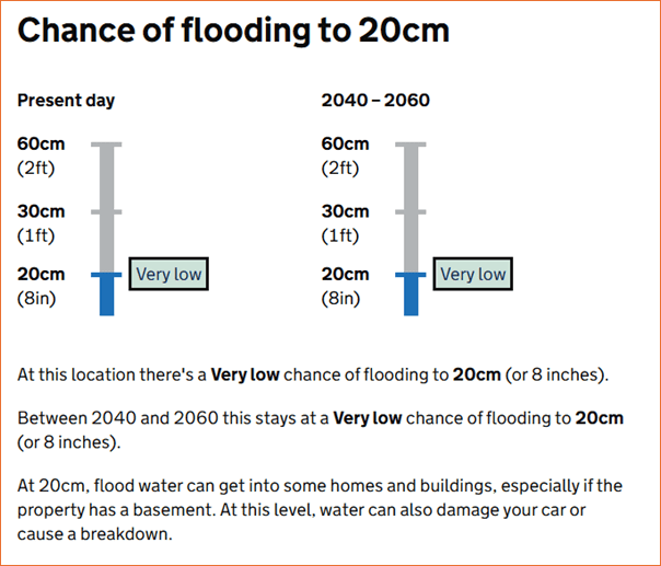
The system provides yearly flood probabilities for both the present and future (2040–2060). It includes:
- Flood spread maps: Showing areas likely to be impacted by flooding.


The new RoFSW Depth datasets show the annual chance of flooding beyond a specific depth, for depths at intervals from 20cm to 120cm. For example, the 20cm dataset shows a map of likelihood of flooding beyond 20cm depth within 4 likelihood bands.
- Flood depth projections: Indicating possible floodwater depths each year:
- Beyond 20cm: Can enter basements and damage vehicles.
- Beyond 30cm: Can enter buildings and disrupt roads.
- Beyond 60cm: Can flood homes and float most vehicles.
- Beyond 90cm and beyond 1.2m: Severe flooding scenarios available for high-risk zones.
Flooding from Rivers and the Sea
- Annual flood probability maps for current and future conditions (2036–2069).
- Impact of flood defences on potential flood risk.
- Similar flood depth categories as surface water assessments.

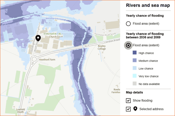
Understanding the ‘Check Your Long-Term Flood Risk’ Map
This government service provides:
- Long-term flood risk insights for properties and communities.
- Climate change-based flood risk predictions.
- Flood causes and risk management options.
It includes data on:
- River and coastal flooding.
- Surface water flooding.
- Reservoir flooding.
- Groundwater flooding (where data is available).
This service is separate from the ‘Flood Map for Planning (Rivers and Sea),’ scheduled for an update in March 2025.
Key Advancements in NaFRA2: Why It’s Better
The NaFRA2 methodology improves flood risk mapping by:
- Allowing for regular updates based on the latest research.
- Combining national-scale models with local flood risk data.
- Enhancing high-resolution mapping for clearer insights.
- Providing improved impact analysis for properties, infrastructure, and insurance planning.
Key Findings:
- Surface Water Flooding:
- 4.6 million properties are in at-risk areas (43% increase from prior assessments).
- 1.1 million properties face high risk, nearly three times previous estimates.
- The number of properties at medium risk has also risen significantly.
- Flooding from Rivers and the Sea:
- 2.4 million properties remain at risk, similar to past assessments.
- 367,900 properties are in high-risk areas (88% increase from past estimates).
- Many properties previously classified as medium-risk are now categorised as high-risk.
Why Have Flood Risk Estimates Changed?
The increase in at-risk properties reflects improved data accuracy, rather than a real-world increase in flooding. Key reasons include:
- Better flood simulation models incorporating real-time climate data.
- Urban drainage system analysis showing capacity shortfalls.
- More precise floodwater spread modelling in densely populated areas.
- Enhanced surface water flood risk assessments, correcting past map limitations.
Upcoming Changes and Future Updates
The EA estimates that nearly 90% of at-risk properties in England now have NaFRA2-based assessments. However, full national coverage will require additional refinements:
- Some areas need localised flood modelling to improve accuracy.
- Data gaps and errors are being addressed in future updates.
The goal is to achieve 100% NaFRA2 coverage by Summer 2026.
Key Future Milestones:
- 25 March 2025: Release of new ‘Flood Zone’ data on the ‘Flood Map for Planning.’
- Ongoing: Model refinements and expanded data accuracy efforts.
How Unda Can Help You Understand Flood Risk
For a comprehensive flood risk assessment, contact Unda. Our expertise helps individuals, businesses, and local governments:
- Interpret NaFRA2 flood risk data.
- Develop effective flood resilience and mitigation strategies.
- Plan for property investments with accurate flood risk insights.
Contact us today to understand how NaFRA2 impacts your area.
Latest news





One of our experienced Flood Risk Consultants will get back to you within 60 minutes