Why the Somerset Levels flood — and what £50m will (and won’t) fix
Estimated reading time 7 minutes
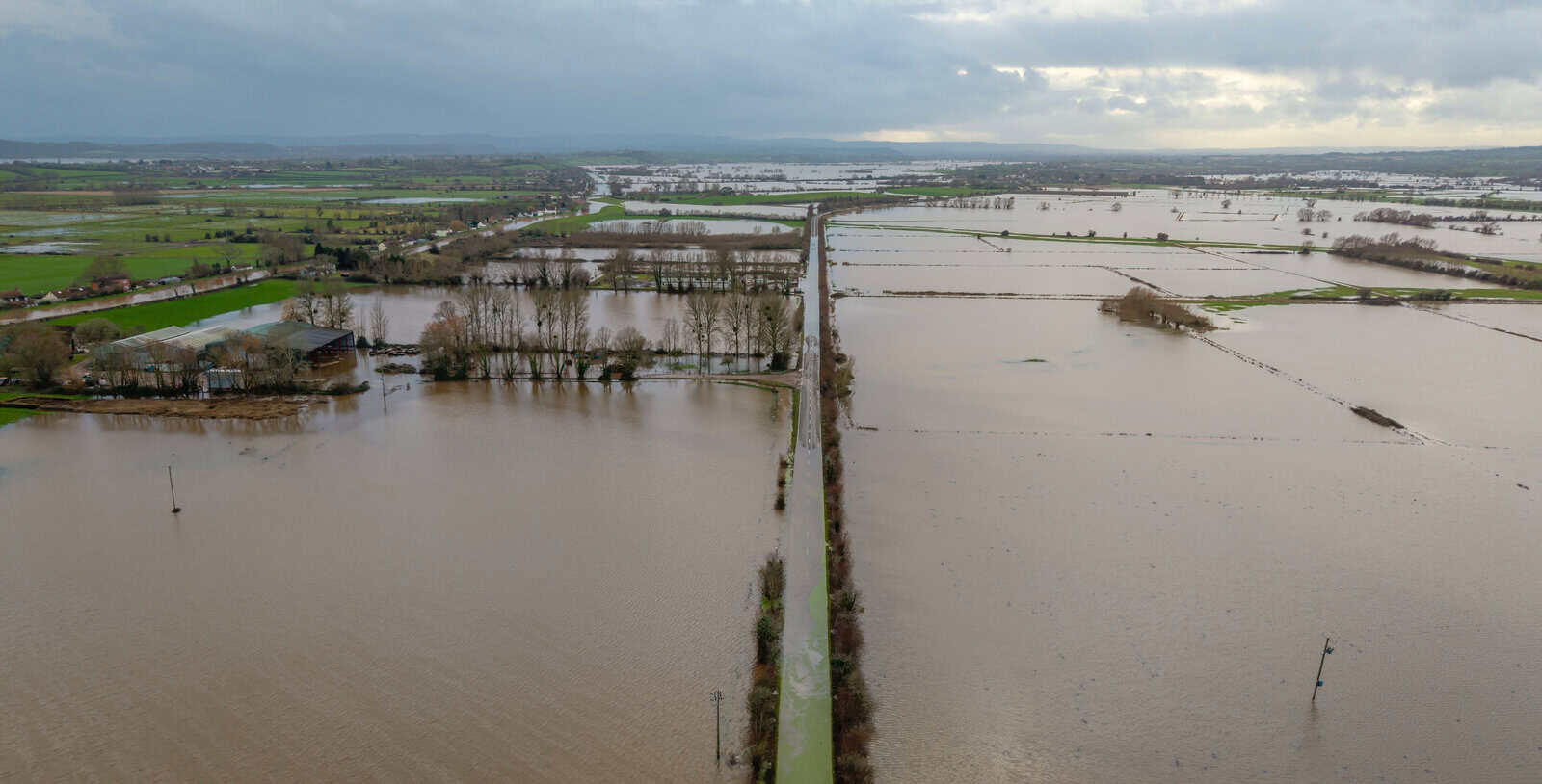
The Somerset Levels flood because they are a low-lying former wetland, much of which sits at or below the level of the rivers and tides meant to drain it. In a wet winter, water arrives faster than the catchment can shed it. That is the backdrop to the government's new £50 million Somerset flood fund, announced on 9th June 2026 after the county recorded its second wettest January since records began in 1871. The money is real and welcome. It is also worth being clear, from a flood risk point of view, about what Somerset Levels flooding the fund can realistically reduce and what it cannot.
This piece sets out why the Levels and Moors flood, what happened in the winter of 2026, what the £50 million is meant to pay for, and where the limits of any such investment lie.
Why do the Somerset Levels flood?
The Somerset Levels and Moors are a flat, low-lying coastal plain: historic wetland reclaimed for farming over centuries. Several things combine to make the area unusually prone to flooding. The land has very little gradient, so water moves slowly. Much of it lies close to, or below, high tide level, which means the main rivers (chiefly the Parrett and the Tone) can only discharge to the sea when the tide is low enough. When heavy rain coincides with high spring tides, the rivers back up and spill onto the surrounding moors.
The soils make it worse. Large parts of the Levels sit on peat and clay that hold water rather than letting it drain away. The result is a landscape that has always flooded and always will. Flooding here is a natural function of the place, not simply a failure of defences, and that distinction shapes what any investment can and cannot achieve.
What happened in Somerset in the winter of 2026?
Somerset had its second wettest January on record in 2026, with more than double the average rainfall, according to the government's announcement. A third of the month's rain fell in just two days. At the peak of Storm Chandra, near the end of January, the Somerset Rivers Authority reported that 1.2 million cubic metres of water an hour was travelling down the Tone and Parrett catchments towards the Levels and Moors.
As the flooding continued into February, Somerset Council declared a major incident. Around 100 properties were reported flooded internally. Existing defences, deployed pumps and Environment Agency teams working around the clock meant a further 2,860 properties were protected. Over the previous two years, new and improved defences across Somerset had already helped better protect 4,916 properties. The winter was a reminder that the system can hold a great deal of water back, but not all of it, and not indefinitely.
What is the £50 million Somerset flood fund?
The £50 million is a one-off government investment awarded to Somerset Council to strengthen flood resilience across the county. It was announced on 9 June 2026 by Floods Minister Emma Hardy, following her visit to Somerset during the February major incident. The council has said it will use the money to develop a two-year programme of measures to reduce flood risk, improve preparedness and strengthen long-term resilience.
It is, importantly, at an early stage. Somerset Council has set out emerging themes rather than confirmed schemes: reviewing and learning from recent flood events, engineering and infrastructure improvements in high-risk areas, natural flood management, support for property-level flood protection, and closer work with local communities. As Councillor Bill Revans, Leader of Somerset Council, put it: “We're at a very early stage and we look forward to engaging with our residents and businesses as we develop a clear plan for delivery.”
What will the £50 million pay for, and what won't it fix?
The fund is meant to pay for a range of flood resilience measures: improved water management infrastructure, enhanced flood defence schemes, nature-based solutions and better watercourse maintenance. The aim is to reduce the burden on emergency responders and help communities withstand future incidents, while protecting the farmland that makes Somerset one of England's most important agricultural counties.
A few of these measures are worth understanding in their own right:
-
Nature-based and natural flood management
This means slowing water in the upper catchment using features such as leaky dams and restored, water-retaining spongy landscapes. They take the edge off frequent floods but do progressively less against extreme events, and the evidence base for nature-based measures at catchment scale is still maturing.
-
Property-level protection
Property flood resilience measures keep water out of buildings, or speed recovery when it gets in, managing the risk that remains after defences have done their job.
-
Watercourse maintenance
Keeping channels clear so they carry water as designed is a duty that often falls to landowners under riparian ownership.
What £50 million will not do is remove flood risk. No scheme does. Defences reduce the probability of flooding, not the possibility of it, a point we cover in our guide to residual flood risk. A defended area can still flood if a barrier is overtopped, a defence is breached, or a flood exceeds the level it was designed for. On the Levels, where tidal locking and a flat gradient are permanent features, and where much of the risk is also tidal, the honest framing is that the fund will make the county more resilient, not flood-proof.
How does the fund fit national flood funding and forecasting?
The £50 million sits alongside the government's wider £10.5 billion flood resilience programme, described as the largest ever, which runs until 2036 to build new defences and restore existing ones across England. For how that national programme is allocated year to year, including named Somerset schemes such as the Bridgwater Tidal Barrier, see our explainer on the £1.4 billion flood defence funding for 2026/27. It also lands as the wider system for paying for schemes is being reshaped under the 2026 FCERM funding reform.
Money is only as useful as the delivery behind it, and large schemes can slip: the delays to the River Thames Scheme are a reminder that a funding announcement is the start of a long process, not the end. Alongside the money, the Environment Agency has launched a National Flood Forecasting and Warning Service, bringing forecasting, modelling and warning functions into a single 170-strong national team. The agency has also confirmed that 93% of its flood defences now meet their required condition, against a target of 92%, with the target for the most critical assets rising to 93.5% in 2026/27. Better forecasting and better-maintained assets do not stop floods, but they buy time, the time that let 2,860 Somerset properties stay dry last winter.
What does this mean for developers, farmers and landowners?
For anyone developing, buying or farming land in Somerset, the fund changes the funding picture, not the planning one. A site-specific flood risk assessment is still required wherever national planning policy demands it, and upstream natural flood management does not exempt an individual site from assessing and managing its own risk. If anything, the renewed focus on Somerset's flooding means local planning authorities and the Environment Agency are likely to scrutinise flood risk and drainage more closely, not less.
Landowners on or near the Levels should also be clear on their watercourse maintenance responsibilities, which the fund's emphasis on better-maintained channels brings to the fore. For farms, the agricultural case is explicit in the government's reasoning: repeated flooding threatens rural livelihoods and feeds rising food costs through the supply chain, so resilience on farmland is part of why the money is being spent.
Speak to a flood risk specialist
If you are planning development, buying property, or managing land in Somerset or anywhere on the Levels and Moors, a clear understanding of your site's flood risk matters more than any headline figure. Unda prepares site-specific flood risk assessments for planning that satisfy the Environment Agency and Lead Local Flood Authorities, and advises on drainage and flood resilience across England. Explore our flood risk assessment services or get in touch to discuss your site.
Latest news






One of our experienced Flood Risk Consultants will get back to you within 60 minutes
