VE Day and the Weaponisation of Flooding in the Netherlands
Estimated reading time 12 minutes
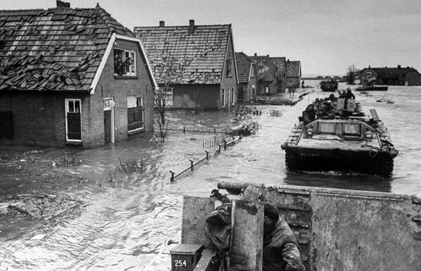
In the closing weeks of the Second World War, as Nazi Germany faced certain defeat, its occupying forces in the Netherlands turned water against the people it had once kept safe. The deliberate breaching of dikes and the release of river dams, the weaponisation of flooding, was a scorched-earth tactic meant to slow the Allied advance, and it left scars on the Dutch landscape that outlasted the war itself. When VE Day arrived on 8 May 1945, large parts of the country were still under water. For those communities, victory in Europe did not end the emergency. It began the long work of pumping the land dry.
Deliberate inundation displaced tens of thousands of Dutch civilians in the final months of the war, and some polders stayed flooded well after the fighting stopped.
Why is the Netherlands so vulnerable to flooding?
The Netherlands is one of the most water-shaped nations on earth, and centuries of engineering are all that keep the low country dry and farmed.
- About a quarter below sea level: roughly 26% of the country sits below sea level.
- More than half flood-prone: over 55% of the land area is at risk of flooding from the sea or the great rivers.
- A defended landscape: dikes, polders, sluices and pumping stations hold the water back and keep the land productive.
That same infrastructure is what makes flooding such a potent weapon there. A defence system precise enough to keep the sea out can, if reversed, let it in on command. During the occupation, the Dutch network of dikes and sluices became both a strategic asset and a target, because whoever controlled the water controlled the ground. Reading the events of 1944–45 means understanding how this differs from ordinary river or coastal flooding. It also carries a lesson that outlives the war: a defended landscape is never a risk-free one, and judging what happens when a defence is compromised is exactly the question at the heart of any modern flood risk assessment.
Flooding as a weapon of war: a long Dutch tradition
Deliberate flooding was not a German invention. The Dutch themselves pioneered inundation as a defensive weapon during the Eighty Years' War against Spain (1568–1648), opening dikes and sluices to turn low-lying land into an impassable barrier of shallow water. In 1584, defenders flooded the area around the town of Saeftinghe to hold back Spanish forces. The sea was never fully driven back, and the “drowned land of Saeftinghe” remains a tidal marsh to this day.
From this grew one of history's most remarkable defensive systems: the Hollandic Water Line and, later, the New Dutch Waterline. The principle was simple, and deliberately modest. Land was flooded to a depth of roughly 30 to 60 centimetres: too shallow for boats to sail, too deep and soft underfoot for soldiers, horses and artillery to cross.
A network of forts, dikes, sluices, pumping stations, canals and inundation polders, working in concert to protect the Netherlands by applying the principle of temporary flooding of the land.
UNESCO, on the Dutch Water Defence Lines
These lines ran for more than 200 kilometres and were maintained into the twentieth century. Their military value faded once aircraft could fly over standing water, but they were not forgotten: the Dutch Water Defence Lines were inscribed as a UNESCO World Heritage Site in 2021, an extension of the earlier Defence Line of Amsterdam. This is the context that matters for VE Day. By 1945, the Dutch had used water as a shield for centuries. What changed was that an occupying army now used it as a sword.
How did German forces use flooding before VE Day?
As Allied troops pushed to liberate the northern Netherlands in early 1945, German forces adopted a scorched-earth strategy, and the deliberate breaching of flood defences was among its most damaging elements. The intent was partly tactical, to bog down Allied movement and deny usable ground, and partly punitive: it wrecked the engineering that had made the land productive in the first place.
| Location | Date | Action | Effect |
|---|---|---|---|
| Ooijpolder / Betuwe | December 1944 | Dikes breached with explosives | Neder-Betuwe flooded; civilians forced onto higher ground |
| Kranenburg area | February 1945 | Roer and Urft dams released | Roer valley flooded for about two weeks; delayed Operation Grenade |
| Wieringermeer | 17 April 1945 | Dike breached in two places | Around 200 km² polder submerged; roughly 7,000 residents displaced |
| Zeeland (Zuid-Beveland, Tholen) | 1944–45 | Coastal and river inundation | Disrupted supply lines; deepened civilian hardship |
The Wieringermeer inundation, 17 April 1945
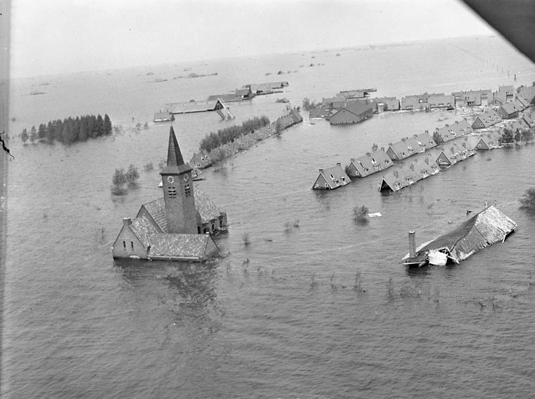
On 17 April 1945, just three weeks before VE Day, retreating German forces used explosives to breach the dike protecting the Wieringermeer polder in two places. Fresh water from the IJsselmeer poured in, and within two days roughly 200 square kilometres lay under water: some 20,000 hectares of land reclaimed from the Zuiderzee only fifteen years earlier.
The Wieringermeer had been a showpiece of Dutch land reclamation, home to around 7,000 people and productive farms. Its loss was both a strategic act and a humanitarian one. The precise military reasoning is still debated, and one likely aim was to deny the Allies dry, open ground for airborne landings, but the civilian cost was not in doubt. The inhabitants of Wieringerwerf, Middenmeer and Slootdorp, along with people who had been in hiding there, fled to safety; remarkably, there were no direct deaths. The polder was pumped dry again by the end of 1945.
The Betuwe and the December 1944 breaches
Months earlier, in the Betuwe between the Waal and the Rhine, German engineers had already turned to water. By breaching dikes near Ommeren and blowing a large gap in the Ooijpolder dike in December 1944, they flooded the Neder-Betuwe, complicating Allied operations and driving civilians onto higher ground. Further south, parts of Zeeland (Zeelandic Flanders, Zuid-Beveland and Tholen) were inundated to disrupt the liberation, obstructing movement and supply while deepening the suffering of local people.
Kranenburg and Operation Veritable
Further east, flooding shaped one of the war's hardest-fought advances. During Operation Veritable (8 February to 11 March 1945), the Anglo-Canadian push to clear German forces between the Rhine and the Maas, the Germans released water from the Roer and Urft dams and jammed the sluices open to keep it flowing. The river rose at around two feet an hour, and the valley downstream stayed flooded for roughly two weeks.
The consequence was strategic. The deliberate flooding of the Roer delayed the American Operation Grenade, the southern arm of the Allied pincer, for about a fortnight, and left the ground around Kranenburg waterlogged and hard for armour to cross.
VE Day: liberation while the water remained
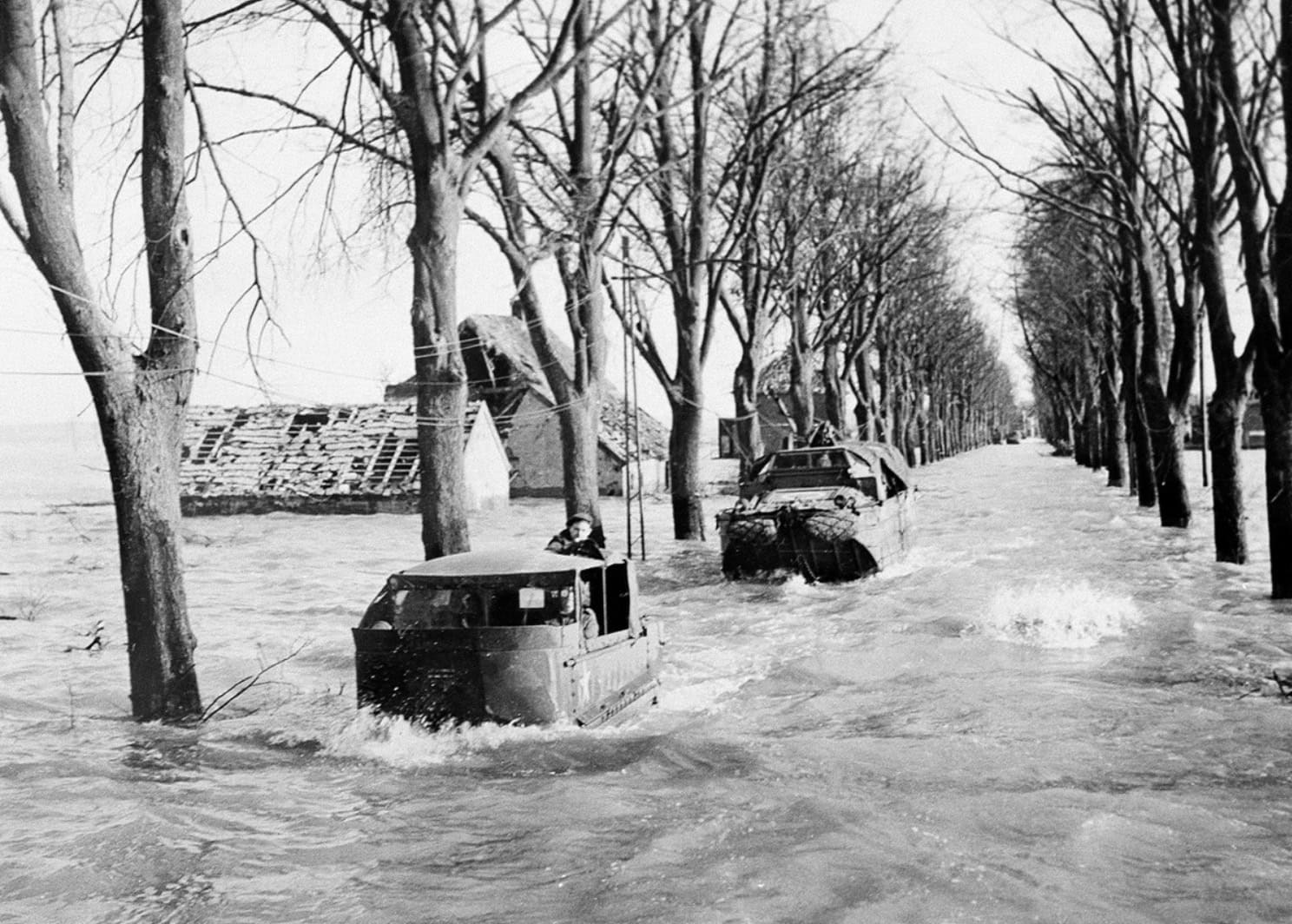
On 8 May 1945, VE Day marked the formal end of the war in Europe, and across the continent people poured into the streets. In the flooded Dutch provinces, the mood was more complicated. Homes could not be reoccupied, fields could not be farmed, and roads stayed impassable. Occupation had ended, but the water had not receded.
For many Dutch communities, VE Day was not the day the emergency ended. It was the day the recovery began.
The end of the fighting simply shifted the task from survival to reconstruction: sealing breaches, pumping out polders, and rebuilding the farms and villages that deliberate inundation had wrecked.
What did the wartime floods leave behind?
The floods of 1944–45 changed how the Netherlands thought about water. It was no longer only a natural hazard; it was something that could be targeted, overwhelmed or manipulated. Post-war reconstruction went beyond simple repair. It strengthened dikes, modernised pumping systems and folded flood resilience into national spatial planning.
That thinking found its fullest expression after a natural disaster. The catastrophic North Sea flood of the night of 31 January to 1 February 1953 killed 1,836 people in the Netherlands and prompted the Delta Works, the vast system of dams, sluices, levees and storm-surge barriers that defend against tidal flooding, including the Oosterscheldekering and the Maeslantkering, completed in 1998. The 1953 flood was the immediate trigger, but the wartime experience had already taught a harder lesson: flood infrastructure is only as safe as it is defensible. Like London's Thames Barrier, the Delta Works answered to more than nature. It answered to the knowledge that defences can fail, or be made to fail.
Is using flooding as a weapon a war crime?
Since 1945, the deliberate targeting of flood defences has been constrained by international humanitarian law. The 1977 Additional Protocol I to the Geneva Conventions gives special protection to what it calls “works and installations containing dangerous forces”.
Works or installations containing dangerous forces, namely dams, dykes and nuclear electrical generating stations, shall not be made the object of attack, even where these objects are military objectives, if such attack may cause the release of dangerous forces and consequent severe losses among the civilian population.
Article 56, Additional Protocol I (1977)
Under Article 85 of the same Protocol, launching such an attack in the knowledge that it will cause excessive civilian loss is a grave breach, in other words a war crime, and the protection is now recognised as a rule of customary international law. The events in the Netherlands, among others, helped establish why the destruction of a dike or a dam is treated as categorically different from ordinary military action.
Water as a weapon today
The weaponisation of flooding did not end in 1945. On 6 June 2023, the Kakhovka Dam on Ukraine's Dnipro River was destroyed, sending a wall of water across more than 600 square kilometres of inhabited land and releasing an estimated 16.4 cubic kilometres of water toward the Black Sea. Tens of thousands of people were affected, and pollutants and sediment scoured from the reservoir created an environmental burden that will last for years.
The Kakhovka Dam collapse released around 16.4 cubic kilometres of water and inundated more than 600 square kilometres, a modern echo of the tactics used in the Netherlands eight decades earlier.
The parallel is uncomfortable but instructive. Whether in the polders of 1945 or the Dnipro basin of 2023, attacking water infrastructure produces the same signature: rapid, wide-area flooding, mass displacement, and long-term damage to land and livelihoods that far outlasts the military moment.
What the Netherlands teaches flood risk professionals
For those who assess and manage flood risk today, the Dutch experience is more than history. It is a reminder that flood defences sit at the meeting point of engineering, policy and public safety, and that a system's real protection depends on more than its design standard. The same questions raised in 1945, what happens when a defence is compromised and who bears the consequences, run straight through modern practice, from residual flood risk to the condition of the defences we rely on and the question of who is responsible for managing that risk.
The lesson is one of integrated resilience: protecting critical infrastructure against failure of every kind, natural or deliberate, and planning for what happens if a defence is overtopped, breached or simply neglected. That is the mindset Unda brings to every assessment.
If you need to understand the flood risk affecting a site or a development, Unda's chartered flood risk consultants can help, from a first appraisal through to a full assessment for planning.
Frequently asked questions
How deep does deliberate floodwater need to be to stop an advancing army?
Surprisingly shallow. The Dutch water lines were designed to hold water at roughly 30 to 60 centimetres, deep enough to hide ditches and soften the ground so that soldiers, horses and wheeled artillery bogged down, but too shallow to let boats through. The aim was never to drown the terrain, only to make it impassable.
Did the 1945 inundations cause many deaths?
The picture varies by place. The Wieringermeer flooding of April 1945 displaced around 7,000 people but caused no direct deaths, because the area was evacuated first. Elsewhere the human cost came less from drowning than from displacement, lost harvests and the collapse of food supply and shelter in the final, hungry winter of the war.
Why did occupying forces flood farmland and polders rather than towns?
Because the military value lay in the ground itself. Flooding open, low-lying land denied the Allies places to land aircraft and gliders, blocked routes for vehicles and supplies, and slowed the advance, all without the occupier having to hold the terrain. It was a way to turn the landscape into an obstacle and then withdraw.
Are the Dutch water defence lines still used for defence today?
No. Their military role ended once aircraft could overfly standing water, and they were effectively obsolete by the Second World War. Today they are preserved as heritage: the Dutch Water Defence Lines, including the New Dutch Waterline, were added to the UNESCO World Heritage List in 2021.
About the author. Edward is a co-founder and Director of Unda with 20+ years in flood risk and drainage, and a national-press commentator on flooding. Unda has been trading since 2014, is a CIWEM Business Partner with CIWEM member and chartered (C.WEM MCIWEM) consultants, and has delivered 5,000+ flood risk assessments and drainage strategies across England and Wales.
Edward Bouët · BSc (Hons)
Latest news






One of our experienced Flood Risk Consultants will get back to you within 60 minutes
