Thames Barrier: Closures, Cost and Its Future

Estimated reading time 18 minutes
The Thames Barrier has closed 221 times for flood defence since it became operational in 1982, a figure the Environment Agency states as correct at 17 November 2025. Of those Thames Barrier closures, 119 held back a tidal surge from the North Sea and 102 were against combined tidal and river flooding. It was designed to close two or three times a year. It has averaged closer to five, and the trend is upward.
The Barrier spans 520 metres of the River Thames near Woolwich and protects 125 square kilometres of central London, 1.42 million people and £321 billion of residential property.
That is the short answer to the question most people arrive with. What follows is the longer one: how the Barrier works, what it cost, why it closes far more often than its designers expected, and the question the Environment Agency now has to settle by 2040. Is London's flood defence against tidal surges upgraded, or replaced, and when?
What and Where Is the Thames Barrier?
The Thames Barrier is a movable flood barrier across the tidal Thames at Woolwich in east London, with its northern end at Silvertown in the London Borough of Newham and its southern end at New Charlton in the Royal Borough of Greenwich. The site was chosen because the banks run unusually straight there and the chalk beneath the riverbed is strong enough to carry the structure.
Across its 520-metre span the Barrier divides the river into ten separate openings. Four are wide navigable channels for shipping, framed by the steel-hooded piers that are now a familiar part of the London skyline.
It is a barrier rather than a barrage, and the distinction matters. A barrage holds water back permanently and regulates what passes; the Thames Barrier stands open, with the tide running through it twice a day, and closes only when a surge is forecast.
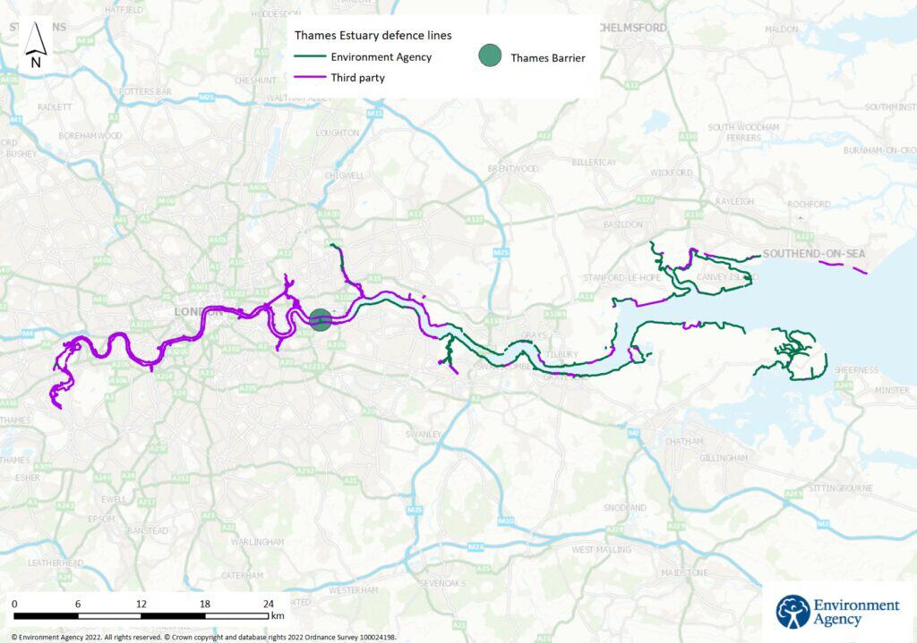
It is not the only thing keeping London dry, and it never was. Embankments, raised river walls, smaller barriers on the tributaries and the completed Thames Tideway Tunnel all play a part, and surface water flooding is managed separately through the London Surface Water Strategy. The Barrier is the part of that system that holds back a storm surge, the mechanism behind the most damaging tidal flooding London faces.
One consequence trips people up repeatedly: a site can sit squarely behind the Barrier and still be in a mapped flood zone, because the mapping shows the underlying risk rather than the defence in front of it. That is why development on the tidal Thames still needs a flood risk assessment for planning, whatever the defence line looks like on a drawing.
How Often Is the Thames Barrier Used?
The Barrier has closed 221 times for flood defence purposes since 1982, correct as at 17 November 2025, of which 119 were against tidal surges alone and 102 against combined tidal and fluvial conditions. Set against an original design expectation of two or three closures a year that is roughly double, and the increase is nowhere near evenly spread across the four decades that produced it. Closure frequency follows the combination that produces an extreme water level rather than surge magnitude alone, which is why a comparatively unremarkable surge coinciding with a high spring tide and a saturated upstream catchment triggers a closure that a larger surge on a neap tide would not.
| Decade | Closures for flood defence | Average per year |
|---|---|---|
| 1980s (from 1982) | 4 | About 0.5 |
| 1990s | 35 | 3.5 |
| 2000s | 80 | 8.0 |
| 2010s | 74 | 7.4 |
| 2020s (to late 2025) | 28 | About 4.7 |
The single most extreme period was the winter of 2013–14, when the Barrier closed 50 times in 13 weeks.
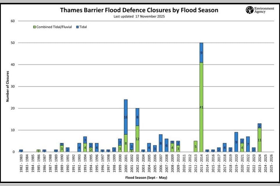
The Environment Agency's own 15-year monitoring review of the Thames Estuary 2100 plan, published in August 2026, records 211 closures for flood defence between 1982 and 2025 and finds a statistically significant upward trend since operations began. The two published counts sit on slightly different bases and cut-offs, so quote whichever you use with its source and its date rather than treating them as interchangeable.
Where the count is heading matters more than the exact total. The Financial Times reported in August 2026 that closures are expected to reach 50 a year by 2035. If that holds, the record season of 2013–14 becomes an ordinary year inside a decade, and a structure designed for occasional use is being asked to run as routine infrastructure.
How Does the Thames Barrier Work?
Ten steel gates rest out of sight on the riverbed under normal conditions, letting ships pass freely overhead, and rotate upwards into a continuous steel wall when a dangerous tide is forecast. The four main gates weigh around 3,300 tonnes each and, when raised, stand as high as a five-storey building and as wide as the opening of Tower Bridge.
A closure runs in sequence rather than all at once:
- A dangerous tide is forecast. The modelled still water level combines the predicted astronomical tide, the surge running down the North Sea and the fluvial flow already coming downstream.
- The Duty Controller decides. The final decision to close rests with the Thames Barrier Duty Controller, working from those forecasts.
- The gates rotate up. The hollow gates turn up from the riverbed, filling with water as they go, until they form a continuous steel wall facing the incoming surge.
- The Barrier holds. A full closure takes around 90 minutes, with the gates raised in sequence rather than all at once.
- The gates are lowered. Once the tide outside has dropped below the level held back upstream, the gates are lowered in a controlled release so the river can flow on towards the sea.
Testing and Readiness
The decision itself is a forecasting judgement rather than a reading taken on the day, and dangerous tides can be identified up to 36 hours ahead.
- Monthly. Each gate is tested on its own, through the year.
- Annually. The whole Barrier is closed for a full tide test, which is the only day of the year all ten gates are raised together.
Why Was the Thames Barrier Built?
The Barrier exists because London decided, after 1953, that raising its river walls indefinitely was not a strategy. A North Sea surge in 1928 had already overwhelmed the Thames embankments and drowned fourteen people in central London basements. The 1953 North Sea flood was far larger, and it forced the question of how to protect the capital for good.
The Waverley Committee, set up to investigate that flood, recommended a structure across the Thames that could be closed against a surge rather than walls built ever higher. That recommendation is the Barrier's origin, and it is also the reason the estuary is managed as one adaptive system rather than a fixed line.
The engineering answer came later, from Charles Draper. In 1969, working from his parents' house in Wood Green, he built a model of a rising gate that rotated into place rather than dropping from above; the idea for the rotating cylinders came from the taps on his gas cooker. It solved the central problem of keeping the river open to shipping while still being able to seal it within minutes, and it is why the Institution of Civil Engineers still treats the Barrier as a reference project for movable flood defence.
The Thames Barrier and Flood Prevention Act authorised construction in 1972. Work began on site in 1974, with the gates fabricated on the River Tees and floated down to the Thames. The first full trial of all ten gates took place in October 1982, and the Queen formally opened the completed Barrier on 8 May 1984.
How Much Did the Thames Barrier Cost?
The Barrier cost around £535 million to build, which the Environment Agency puts at about £2.4 billion in today's money. Strengthening the river defences downstream added roughly £100 million more at the time.
Those are construction figures only. A structure of this scale needs constant inspection, testing and maintenance, and that cost has run for more than forty years. The forward figure is larger again.
The Environment Agency expects the Thames Estuary 2100 plan to cost around £16.2 billion between 2023 and 2100, a figure that has risen by about 50% since 2012.
That estimate covers securing land for future defences, maintaining and upgrading the existing ones, creating habitat, and replacing the Thames Barrier by 2070. The rise since 2012 is attributed to inflation, defences deteriorating faster than expected, and a better understanding of the system than the original plan had.
What Would Happen If the Thames Barrier Failed?
What happens if the Thames Barrier fails is not a hypothetical the Environment Agency treats lightly: a failure during a major surge would be one of the most serious peacetime emergencies London could face. Around 125 square kilometres of central London sits in the tidal floodplain the Barrier defends, and the exposure behind it is unusually concentrated:
- People. 1.42 million people live in the area the Barrier defends.
- Property. £321 billion of residential property.
- Transport. 116 railway and Tube stations, and more than 300km of major roads.
- Health. 711 healthcare sites.
- Heritage. Four World Heritage sites and more than 4,000 listed buildings.
In practice the risk of outright failure is low. The Barrier is rigorously maintained, dangerous tides are forecast well in advance, and closures are planned rather than scrambled. Residual flood risk is not the same as failure risk, and the harder question is not whether the gates work on the day but how long they can keep delivering the same standard of protection.
Criticisms, Disadvantages and Limitations
The Barrier has three real limitations, and they are worth stating plainly. It was designed mainly for tidal surges rather than the prolonged high river flows that more intense rainfall is making more common. It has passed forty years in service. And it is being asked to close far more often than its designers envisaged, which raises questions about wear and long-term reliability that a lower duty cycle would never have raised.
The most important limitation is the quietest one. The Environment Agency expects the Barrier to keep protecting London until around 2070, but the standard of protection it delivers will gradually decline after 2030 as sea levels rise, because the crest stays where it is while the water it holds back does not, and the margin against overtopping is what erodes. Nothing fails. The margin simply narrows, year on year, which is the same pressure now being felt at historic sites across the country where defences built for an earlier climate are tested more often than they were designed for.
There is a wider point about defences generally. A defence reduces flood risk. It never removes it, and the protection it offers is only as good as the state of the assets standing behind it. Nationally, 92.8% of Environment Agency flood defences are at their required condition, against a target of 93.5% by March 2027. Close to one in fourteen is below standard, which is the condition problem the National Audit Office set out for England as a whole. The Barrier itself is well looked after, but the principle holds across the system.
Is the Thames Barrier Still Effective?
Yes, and the Environment Agency's most recent evidence says so directly. Two of its findings should temper how comfortable that answer feels. The 15-year monitoring review of the Thames Estuary 2100 plan, published in August 2026, is the fullest public assessment the estuary's defences have had since the plan was adopted, and on the narrow question of whether the Barrier is still fit for purpose it is unambiguous.
- Sea level. Relative mean sea level in the estuary rose 4.10mm a year between 1993 and 2024, against 3.65mm a year over 1990 to 2018. At Southend-on-Sea the total rise since 1911 is about 0.24m.
- Defence condition. 96.4% of the plan's fixed flood defences are at their required condition, against 92.8% nationally.
- Forecasting. Tide-level forecasts are accurate to ±0.30m to ±0.40m, against a 2030 target of ±0.20m.
- Closures. 211 closures for flood defence between 1982 and 2025, with a statistically significant upward trend since operations began.
- Next review. The next plan review phase, which reassesses the future of the Barrier itself, is expected to start by 2030.
The forecasting figure is the one practitioners should take seriously. Tide-level forecasts accurate to only 30 to 40 centimetres, against a target of 20 centimetres, leave a margin of uncertainty that has to be absorbed somewhere, and the way it is absorbed is by closing the Barrier whenever the forecast is marginal. Those closures still count. A gate has a finite number of duty cycles in it, and one spent on a surge that never arrived is spent all the same. Forecast uncertainty at that magnitude also constrains the sequencing of the wider programme, because the justification for upgrading a defence upstream depends on demonstrating the residual exposure that remains once the Barrier has operated as intended.
The sea level finding is more reassuring than the headline suggests. Relative mean sea level in the estuary rose at 4.10mm a year between 1993 and 2024, up from 3.65mm a year over 1990 to 2018, and that acceleration matches what the plan projected rather than exceeding it. The plan is not being overtaken; it is being confirmed, on a schedule that leaves less slack than the original horizon assumed.
Will the Thames Barrier Be Replaced?
The published plan is to replace the Barrier by 2070, with the decision on which option to take due by 2040. The Environment Agency currently carries seven potential end-of-century options, ranging from upgrading the existing structure to a new barrier further down the estuary, and the £16.2 billion cost estimate is built on that timetable. In August 2026 it came under public question for the first time.
The Financial Times reported that senior Environment Agency officials had told ministers a replacement might be needed between 2050 and 2060, roughly twenty years earlier than the plan assumes, with a new barrier costing at least £20 billion and taking up to thirty years to build. On that arithmetic a 2050s replacement would need to start in the 2020s. The Agency's response was measured rather than a denial:
We are actively assessing options for managing tidal flood risk, including consideration of options for upgrading or replacing the Thames Barrier.
Caroline Douglass · Executive Director for Flood and Coastal Risk Management, Environment Agency
Whatever is decided, the Barrier is only one line in the answer. The plan also raises defences upstream, strengthens river walls along the tidal reach, and buys land now for structures that will not be built for decades, because human-driven sea level rise is already lifting the baseline every one of those assets was designed against, and the research now runs well past the 2100 horizon the plan stops at.
Two things follow for anyone assessing flood risk on the tidal Thames. The first is that the end-of-century option is genuinely open. The next plan review, which the Agency expects to begin by 2030, will reassess the future of the Barrier itself. The second is the point the River Thames Scheme's delays make further upstream: a defence that has been designed is not a defence that has been built, and planning evidence should not lean on either.
What the Thames Barrier Means for Property in London
For anyone who owns, buys or develops property in London, the Barrier is reassuring but it is not the whole picture. Living or building behind a major defence does not take a site out of the floodplain, and it does not remove the need to understand the risk in detail.
This catches people out constantly, and it catches out solicitors and lenders as often as it catches out buyers. A property can sit comfortably behind the Barrier and still appear in a mapped flood zone, because the Flood Map for Planning shows the underlying risk rather than the protection in front of it. A home can sit inside an area benefiting from defences, be in Flood Zone 3, and never have flooded in living memory. In both cases the map shading on its own tells you very little about the real risk to a particular building.
That is where a site-specific assessment earns its place. If you are buying, a flood risk survey for a property purchase shows what the risk actually is and whether the price reflects it. If an insurer has flagged the address, a flood risk assessment for insurance puts property-level evidence in front of the underwriter instead of a postcode score. If you are developing, a flood risk assessment for planning demonstrates that a scheme is safe and will not increase flooding elsewhere, and where the picture is complex, detailed flood modelling and a sound surface water drainage strategy make the difference between an application that stalls and one that proceeds.
Behind the Barrier and still in a flood zone?
A defence line on a map is not a site-specific answer. Our chartered consultants tell you what the risk to your building or your site actually is.
Start a quoteNeed Flood Risk Advice?
Whether you are concerned about a home behind London's defences or planning a development on a site at risk, understanding flood risk properly is the first step to managing it. At Unda we prepare flood risk assessments, drainage strategies and flood modelling for clients across England and Wales, and our free flood risk map and live river levels map will give you a first read on any England postcode before you call.
Contact us to talk through your site, and one of our flood risk consultants will get back to you within 60 minutes.
Frequently Asked Questions
How does the Thames Barrier work?
Ten rotating steel gates rest on the riverbed and turn upwards when a dangerous tide is forecast, forming a solid wall against the surge. A full closure takes about 90 minutes.
When was the Thames Barrier built?
Construction ran from 1974 to 1982. The Barrier became operational in 1982 and was officially opened by the Queen in 1984.
How much did the Thames Barrier cost?
Around £535 million to build, which the Environment Agency puts at about £2.4 billion in today's money, plus roughly £100 million for downstream defences and decades of maintenance since.
How often is the Thames Barrier closed?
It had closed 221 times for flood defence as at 17 November 2025, and the number has risen sharply each decade as sea levels rise and rainfall intensifies.
What would happen if the Thames Barrier failed?
A major surge getting past the Barrier could flood around 125 square kilometres of central London, affecting transport, power, hospitals and landmarks across the floodplain.
What are the disadvantages of the Thames Barrier?
It was designed for tidal surges rather than prolonged river flooding, it is ageing, and it is closing far more often than intended. The Environment Agency expects it to remain effective until around 2070.
Where is the Thames Barrier?
It crosses a 520-metre stretch of the Thames near Woolwich, between Silvertown and New Charlton in east London.
Does the Thames Barrier protect against river flooding as well as tidal surges?
Partly. Just under half its closures have been against combined tidal and fluvial conditions, where a surge coincides with high flows coming downstream. It does nothing for surface water flooding, which is managed separately.
Can you visit the Thames Barrier?
Yes. There is a riverside information centre on the Greenwich bank at New Charlton, and Thames Barrier Park sits opposite on the Silvertown side in Newham. The annual full tide test is the one day of the year all ten gates are raised together.
Does being behind the Thames Barrier take a property out of a flood zone?
No. Flood Zones are mapped on undefended risk, so a property protected by the Barrier can still sit in Flood Zone 3. Only a site-specific assessment tells you what the risk to that building actually is.
About the author. Antony is a Senior Flood Risk and Drainage Consultant leading Unda's drainage and SuDS team. Unda has been trading since 2014, is a CIWEM Business Partner with CIWEM member and chartered (C.WEM MCIWEM) consultants, and has delivered 5,000+ flood risk assessments and drainage strategies across England and Wales.
Antony Rousou · BSc (Hons), C.WEM MCIWEM
Latest news






One of our experienced Flood Risk Consultants will get back to you within 60 minutes
