Still in a Flood Zone After New Flood Defences? What Actually Changes
Estimated reading time 19 minutes
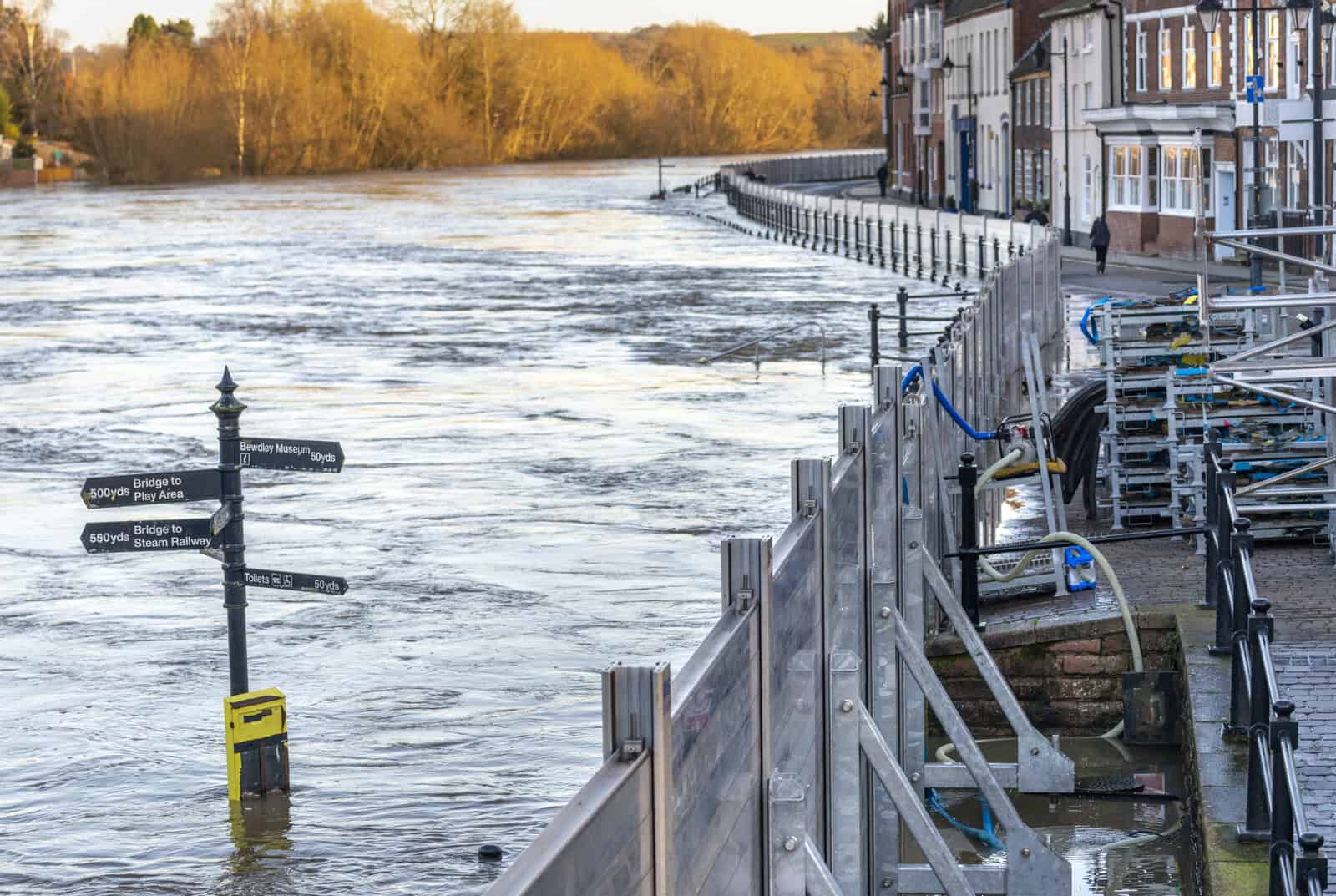
A new flood wall goes up, an embankment is raised, a storage basin is finished after years of consultation. Then you open the map and nothing has moved. If you are still in a flood zone after flood defences have been built, the scheme has not failed and the Environment Agency has not made an error. England’s Flood Zones are drawn as though the defences were not there, on purpose. A wall lowers the flood risk at your address. It does not move the band your address sits in, because the band was never a statement about protection.
What a completed scheme does change sits behind the map rather than on it: the Environment Agency’s defended modelling, the evidence a site-specific assessment can draw on, and the view an insurer or a lender takes of your property. Below is what moves, what stays put, and how to work out which applies to you.
The Flood Zones are the undefended floodplain. A new defence can cut your real risk sharply and leave the shading on the map exactly where it was.
What the Flood Map for Planning is drawn to show
The Flood Map for Planning shows land that could flood from rivers or the sea if the defences were taken away. The Environment Agency puts it in one line on its own service: flood zones show land that could flood from rivers or the sea, “ignoring the benefits of any existing flood defences”. It is a screening tool for planning decisions. It is not a forecast for a single building.
The reason is time. A house approved today may still be standing in a century, and nobody can promise that a wall built in 2026 will still be at its design standard in 2126, because funding moves, ownership moves and condition moves faster than either of them. A defended map would write the opposite assumption into national policy. So the Environment Agency keeps the underlying floodplain visible and leaves the planning system to deal with what happens when a defence is overtopped or fails.
Flood defences reduce the probability of flooding from a specific source, do not completely stop the chance of flooding because there may be a flood that is bigger than the one the defence is designed to protect against, and may provide reduced protection over time because of climate change increasing flood risk in the future.
Environment Agency · Flood Map for Planning
England’s own asset figures show the caution is earned. On 1 April 2026 the Environment Agency reported that 93% of its flood risk assets in high consequence systems were in the required condition, which met the target it had set for the year and, read the other way round, means that seven assets in every hundred protecting the places where failure matters most were not where they should be. Seven per cent is not a rounding error. We have written separately about what happens when protection is recorded as below standard, and about what the National Audit Office found when it looked at the same estate.
More schemes are being finished than at any point in recent memory, which is why this question keeps coming up. The Environment Agency reported 61,898 properties better protected in the two years to April 2026, against a target of 52,000, and the government has committed £1.4 billion for 2026/27 across more than 600 projects, inside a £7.9 billion programme running to March 2036. Our note on the 2026/27 flood defence funding sets out where it goes. Every one of those schemes creates a household who watches the wall go up and then checks the map.
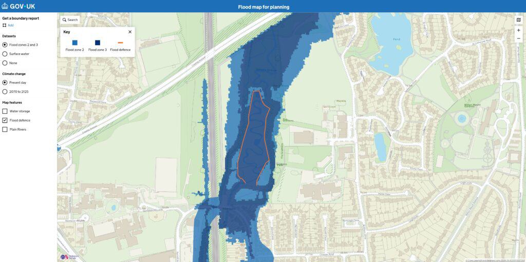
The map carries a second caveat that most readers never see. The Environment Agency states that its extents give an indication of flood risk to an area of land and are not suitable for showing whether an individual property is at risk of flooding. National mapping answers whether flooding needs assessing here. Whether water reaches your threshold is a different question, and it belongs to a flood risk assessment for planning or a survey of the property itself. We have made that argument at length in are flood maps accurate?, and the related question of why a home can be zoned despite never having flooded is answered separately. If your address shows as Flood Zone 3 for planning but “Low” on the public service, that is not a contradiction either, as we explain in the long term flood risk map versus the Flood Map for Planning.
Flood Zone 3b is the only band defined with defences working
Three of England’s four flood zones ignore defences. The fourth counts them. Zones 1, 2 and 3a are set purely by the annual probability of flooding from rivers or the sea, with no infrastructure in the picture at all. The functional floodplain, Zone 3b, is defined as land at a 3.3% or greater annual probability of flooding “with any existing flood risk management infrastructure operating effectively”, or land designed to flood. That asymmetry is the technical heart of the question, and it is almost never stated.
| Flood zone | Annual probability of flooding | Is your defence counted? |
|---|---|---|
| Zone 1 (low) | Less than 0.1% (below 1 in 1,000) | No. Drawn undefended. |
| Zone 2 (medium) | 0.1%–1% rivers, 0.1%–0.5% sea | No. Drawn undefended. |
| Zone 3a (high) | 1% or greater rivers, 0.5% or greater sea | No. Drawn undefended. |
| Zone 3b (functional floodplain) | 3.3% or greater (1 in 30), or land designed to flood | Yes. Assessed with infrastructure operating effectively. |
Zone 3b is the one band your defence is allowed to influence, and it is also the band where development is most heavily restricted.
The practical consequence is narrower than it sounds. Because Zone 3b is assessed with infrastructure operating effectively, a scheme that genuinely takes land out of the 1 in 30 event can change whether that land is treated as functional floodplain, even while the same land stays inside Zone 3a on the published map, which is the one circumstance in which a wall really can move a designation. Zone 3b is not drawn nationally, though. It is defined locally, usually through the council’s Strategic Flood Risk Assessment, so the decision rests with the lead local flood authority and the Environment Agency rather than with a national dataset. The full set of zone definitions, and how the August 2026 framework restated them, sits in our guide to flood zones 1, 2 and 3.
What a completed flood defence does change
A finished scheme changes four things. None of them is the colour on the Flood Map for Planning, and knowing which of the four applies to you is usually worth more than knowing your zone, because a purchase, a policy or a planning application turns on these and not on the shading.
- The defended modelling. Since 25 March 2025 the Flood Zones have been produced under the Environment Agency’s second National Flood Risk Assessment, which builds its picture from four inputs: undefended modelling, defended modelling, recorded flood outlines and suitable third-party data. The defended layer exists and it includes your scheme. It is simply not the layer that draws the zone, as our summary of the NaFRA2 guidance sets out.
- The evidence available to an assessment. A defended extent, an as-built survey and the scheme’s design standard are all material a consultant can model with. This is where a new defence appears in a report even though it never appeared on the map, using the flood modelling tools and techniques a consultant would normally reach for.
- The insurer’s view of the address. Insurers price from their own catastrophe models and claims history rather than from a planning flood zone, and a completed scheme reaches those models on a different timetable from the Environment Agency’s.
- The planning conversation. Once a site is defended, the argument shifts from whether it floods to how it behaves when the defence is exceeded: floor levels, freeboard, safe access, evacuation. That is the territory of residual flood risk.
The Environment Agency has also confirmed that rebuilding the zones under the new assessment did not redraw England in aggregate. Its own analysis found no significant change to the overall size of the Flood Zones at national scale. Where individual boundaries moved, they moved because the modelling improved, not because a defence was switched on.
Since 25 March 2025 the Environment Agency has modelled the defended scenario nationally. It publishes that result as a separate dataset and leaves the Flood Zones undefended.
The national layer that showed your defence working has been withdrawn
There used to be a map answering exactly this question. It no longer exists. “Areas Benefiting from Defences” showed the land that would flood in a 1 in 100 river event or a 1 in 200 sea event if the defences were not there, which is another way of saying the properties a scheme protects. It was retired in December 2022 on the grounds that it no longer met users’ needs.
Its replacement has not arrived either. “Reduction in Risk of Flooding from Rivers and Sea due to Defences” was published in late 2022 to do the same job. The Environment Agency now records it as temporarily discontinued, to be superseded once the national flood risk products settle and pending development of a replacement. A homeowner asking which properties their new wall protects currently has no national dataset to point at.
Something was mapped, and then it was withdrawn. That is why so many people assume the benefit of a defence was never published at all.
What does exist is the pair of present-day extents the Environment Agency put out on 25 March 2025 through the Defra Data Services Platform. The undefended products ignore the presence and condition of defences. The defended products take the defences into account and assume they operate as designed. Both run at the 0.1% annual probability level, and at 1% for rivers and 0.5% for the sea. Those are the layers a consultant reaches for, alongside the banded flood depth data released in August 2026. None of them replaces the Flood Zones, and none of them is what a planning officer opens first.
Standard of protection matters more than your zone
Every defence is built to a design event, expressed as an annual probability. That number is its standard of protection. The Environment Agency’s Newhaven scheme, for example, was designed to a 1 in 200 year standard of protection with an allowance for climate change. Beyond the design event, or if the structure is overtopped or breached, the water still arrives. That leftover exposure is the reason the map keeps the floodplain visible.
- Overtopping. A flood larger than the design event rises over the wall or embankment. The scheme has not failed. It has been exceeded.
- Breach or failure. A structure can fail under load, and condition matters. An ageing or below-standard asset is least reliable under exactly the pressure it was built for.
- A different source entirely. A river defence does nothing about surface water, groundwater or an overwhelmed sewer, and those sources account for most properties at risk in England.
England publishes no single figure for the standard every scheme is built to. Each is set by economic appraisal, so the number is scheme-specific and worth asking for by name. Where a proposal turns on it, hydraulic modelling is what converts a design standard into depths and levels at your boundary. The arithmetic behind a “1 in 100 year” label is unpacked in our guide to flood return periods and annual probability.
A 1 in 100 standard of protection means a 1% chance of the defence being exceeded in any given year, or roughly a one in four chance across a 30 year mortgage.
How long before a new scheme reaches the national mapping?
Flood zones change when the modelling behind them changes, not when a wall goes up, and the modelling changes slowly. A defence does not enter the Environment Agency’s national picture on the day it is finished, and there is no published timetable telling you when it will: it travels through a sequence of survey, recording, modelling and release, and each step waits on the one before it.
- The scheme is completed and surveyed as built, so its crest levels and alignment are known rather than assumed.
- The asset is recorded in the Environment Agency’s spatial flood defence data, with its standard of protection.
- The defence is represented in updated hydraulic modelling, either nationally or through a local model.
- That modelling is accepted into a national data release.
- The Flood Map for Planning and the supporting extents refresh.
The Environment Agency updates the Flood Zones “when new, better information is available and where it meets the required standards”, and the dataset’s own update frequency is recorded as “as needed” rather than annual. Regular updates were paused while the national assessment was rebuilt, and the Agency has said they will be less frequent while the new processes are established, with evidence review requests resuming from January 2026.
A real example helps. The Fowlea Brook scheme in Stoke-on-Trent was completed on 6 February 2026 and lowers flood risk to 333 homes and businesses, extending the channel’s life by 60 years. Nothing on the Flood Map for Planning changed on the day it opened, and nothing was supposed to. We looked at what the scheme unlocks in Stoke-on-Trent when it finished.
England has no published process for challenging a flood zone. A route exists, and a better local model is the thing that persuades the Agency, but the requirements are not set out on a public page the way a planning procedure would be. Our note on the Environment Agency flood map challenge covers what a submission needs to contain in practice.
There is no service standard for getting a completed scheme onto the national map, and no published English procedure for asking.
Wales publishes what England does not
Wales answers the same question with more of it in public. Natural Resources Wales draws its flood zones undefended, exactly as England does. It also publishes a separate planning layer for defended land, and states the standard behind it.
| Question | England | Wales |
|---|---|---|
| Do the flood zones include defences? | No | No. Areas benefitting are mapped separately. |
| Is there a live national layer for defended land? | No. The previous one was retired in 2022 and its successor is discontinued. | Yes. TAN15 Defended Zones, updated May 2026. |
| Is a minimum standard of protection published? | Not as a national figure | Yes. 1 in 100 for rivers, 1 in 200 for the sea, with climate change and freeboard required for defences built from 2016. |
| Is there a published route to challenge the mapping? | No published procedure. Evidence review requests resumed January 2026. | Yes. A published submission process. |
| Do the flood zones include climate change? | No | Yes |
This is less a criticism of the Environment Agency than proof the information can be published at all. One caveat matters. Natural Resources Wales records that its Flood Map for Planning does not yet carry official planning status and that implementation is suspended pending further consultation, so in places the older Development Advice Map still governs. Welsh flood risk sits under a different regime altogether, which we cover in TAN15 and in the Welsh flood map for planning.
Buying, selling or developing behind a flood defence
Staying in a flood zone after new defences does not mean your risk is unchanged. It means the planning map is showing the probability-based floodplain rather than certifying that the risk has gone. Relying on the shading alone misleads in both directions: it overstates the exposure of a well-defended home, and it hides the sources the zones never covered.
- Selling. The TA6 property information form asks about flooding history, not about flood zones. A defence does not erase a past flood from the answer, and it does not have to.
- Buying. A conveyancing flood report screens. It does not assess. What it cannot tell you is how the property behaves when the defence is exceeded, which is the question a purchase behind a wall actually raises. Your conveyancing solicitor’s role is to flag it, not to answer it.
- Insuring. Flood Re eligibility turns on council tax band, property type and a build date before 1 January 2009. It does not turn on your flood zone. The scheme ends in 2039, after which flood cover is expected to be priced on actual risk.
- Borrowing. UK Finance is explicit that buildings insurance with flood cover is a condition of all mortgages, so flood risk reaches lending through the insurance market rather than through the map. We set out how that works in flood risk and mortgage lending.
- Developing. A defended site still sits in its zone for the sequential test, and the Environment Agency will still want floor levels, freeboard, safe access and an evacuation route sized for the residual event.
For a decision that turns on flood risk, a site-specific view beats a colour on a national map. A flood risk assessment for planning shows how a site behaves in modelled scenarios and what the defence does in practice. A flood risk survey for a property purchase does the same for a home you are buying or selling. Where the argument is with an insurer rather than a planner, a flood risk assessment for insurance is the report that carries weight.
Behind a new defence and still shown in a flood zone?
Our experienced consultants can tell you what the scheme actually does at your address, in time for an exchange, a renewal or a determination date.
Get a quote in 60 minutesFrequently asked questions
Will the Environment Agency ever update the map to reflect my defence?
The headline Flood Zones will stay undefended by design, so they are unlikely to be switched off behind a wall however good the scheme is. What can change is the supporting evidence: the defended extents, the recorded asset and any local model. If a boundary near you looks wrong for reasons other than the defence, such as an old dataset or a mis-mapped watercourse, that is the case worth putting to the Agency.
Does being in a flood zone still affect my insurance or mortgage if I’m defended?
It can, because insurers and lenders start from national data before they look at anything specific. The route in is insurance rather than planning. Cover has to be available and affordable, and a lender’s condition is that it exists. A property-level assessment is what puts the defence, the ground levels and the actual exposure in front of an underwriter who would otherwise price the postcode.
Can I challenge or change my flood zone?
There is a route where better local data or hydraulic modelling exists, and the Environment Agency resumed reviewing evidence requests in January 2026. England does not publish the requirements, so the practical approach is to establish what model the Agency currently holds for your reach and whether a better one can be built. Wales, by contrast, publishes its submission process in full.
Do the new defended datasets mean I’m no longer in Flood Zone 3?
No. The defended extents describe how the land behaves with defences operating, which is useful context and sometimes decisive in a report. They sit alongside the Flood Zones rather than replacing them, and planning decisions are still made against the zone.
Who decides whether my land is still functional floodplain?
The lead local flood authority and the Environment Agency, working from the council’s Strategic Flood Risk Assessment rather than from a national layer. Because Zone 3b is the one band defined with infrastructure operating effectively, it is also the one where a completed scheme is worth raising directly with the authority.
My neighbour’s flood zone changed and mine didn’t. Why?
The rebuild under the second National Flood Risk Assessment retained older datasets in some locations until better models arrive, so two nearby addresses can sit on different vintages of evidence. Flood Zones 2 and 3 also stopped overlapping, which re-attributed some land without any change to the modelled risk beneath it.
About the author. Edward is a co-founder and Director of Unda with 20+ years in flood risk and drainage, and a national-press commentator on flooding. Unda has been trading since 2014, is a CIWEM Business Partner with CIWEM member and chartered (C.WEM MCIWEM) consultants, and has delivered 5,000+ flood risk assessments and drainage strategies across England and Wales.
Edward Bouët · BSc (Hons)
Latest news






One of our experienced Flood Risk Consultants will get back to you within 60 minutes