Fowlea Brook flood scheme: what £12.6m has changed in Stoke-on-Trent
Estimated reading time 12 minutes
The Fowlea Brook flood scheme is a £12.6 million Environment Agency project, completed in February 2026, that has rebuilt the defences along a constrained urban watercourse running through the centre of Stoke-on-Trent. It reduces flood risk to 333 homes and businesses and has released a corridor of brownfield land that flood risk had effectively frozen. What it has not done, and could not do, is move those properties out of their mapped flood zone.
That distinction is the reason this scheme is worth reading about carefully rather than filing under good news. For anyone who owns, buys or develops land between Shelton Old Road and the Civic Centre, the practical position after completion is better than it was, and materially different from what the Flood Map for Planning will show you. If you already have a site in the city, our flood risk assessment service in Stoke-on-Trent covers exactly this position.
The scheme cost £12.6 million and unlocked £75 million of regeneration, on land where nine development sites had been held back by flood risk.
Why Fowlea Brook floods
Fowlea Brook is a six-mile tributary of the River Trent that drains the western side of Stoke-on-Trent and joins the Trent near the city centre. Its problem is not volume but speed. The catchment above it is heavily urbanised, the channel through the city is narrow and in long stretches concrete-lined, and rainfall arrives at the brook far faster than it would from open ground.
The Environment Agency's own description of the behaviour is blunt.
While properties in the area have thankfully not flooded since 1997, there is a high risk of flash flooding and water levels can increase by more than a metre in 15 minutes, particularly during summer thunderstorms as we saw in July 2021.
Mark Swain · Flood Risk Team Leader, Environment Agency (March 2024)
A rise of that speed is the defining constraint on the whole reach. It leaves almost no warning time, it rules out defences that someone has to travel to and close by hand, and it means the design case is a short, violent summer storm rather than the prolonged winter flooding that dominates on larger rivers. The 1997 date matters too: a twenty-nine-year gap without property flooding is not evidence that risk is low, it is evidence that the last severe event predates most of the people now living and working alongside the brook.
Stoke-on-Trent's flood risk does not begin and end with the brook. The city's Level 1 Strategic Flood Risk Assessment identifies the Fowlea Brook catchment as a priority for drainage strategy work, and surface water remains a separate risk that no river defence addresses, managed by Stoke-on-Trent City Council as Lead Local Flood Authority.
What the £12.6m scheme built
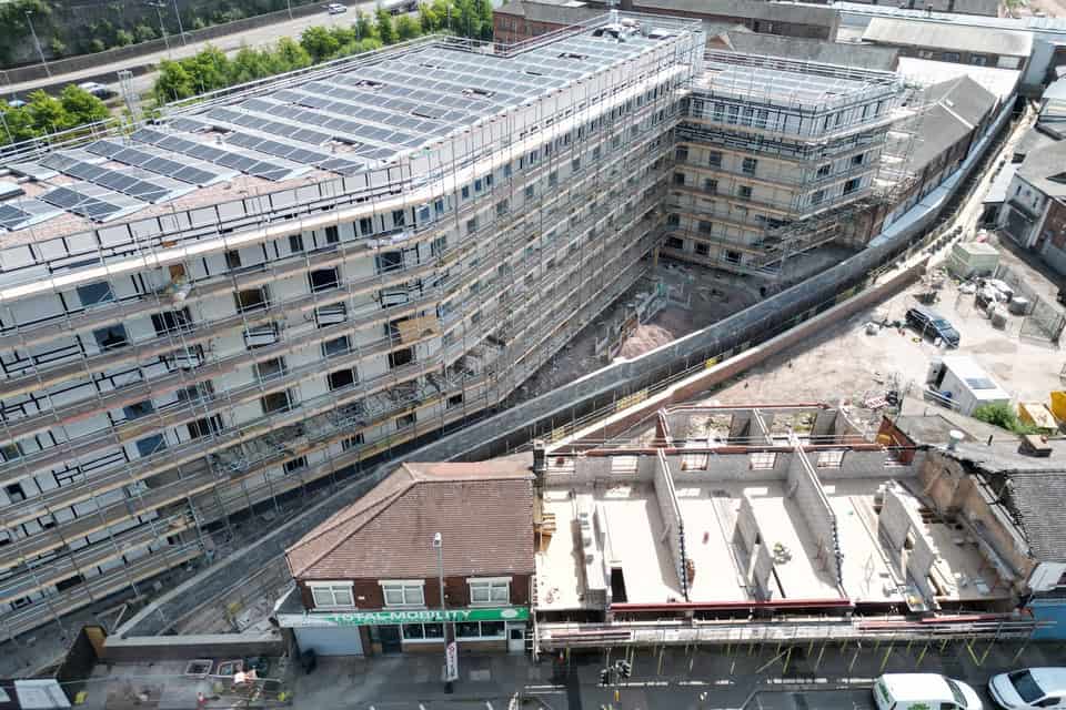
The completed works are conventional hard engineering, delivered in a difficult urban corridor and combined with a long stretch of channel restoration.
- Announced (March 2022). The Environment Agency confirmed a scheme covering the stretch of Fowlea Brook between Shelton Old Road and the Civic Centre, then costed at £6.5 million.
- Construction began (March 2024). Following vegetation clearance the previous year, work started on a scheme by then costed at £10.6 million.
- Defences built. New flood walls, new embankments and a flood gate along the city-centre reach.
- Channel repaired. More than 500 metres of the Fowlea Brook channel repaired and upgraded, extending the life of the flood risk management infrastructure by around 60 years.
- Barrier removed. A weir preventing fish from moving upstream was taken out, reopening 6.5 km of the brook. Brown trout and chub were found during construction.
- Completed (February 2026). The Environment Agency confirmed completion at a final cost of £12.6 million.
Sections of the concrete channel were redesigned to create more natural habitat, which is now a standard expectation on Environment Agency schemes rather than an optional extra. Those measures sit alongside the walls and embankments rather than replacing them; on a catchment this urbanised and this flashy, nature-based drainage on its own could not deliver the standard of protection the city centre needed.
The cost trajectory is worth stating plainly, because it is the part the press releases do not draw together. Between the 2022 announcement and completion, the scheme very nearly doubled in price, from £6.5 million to £12.6 million. BBC News reported the intermediate figure when construction began.
What the scheme protects, and what it cost
| Measure | Figure | Source |
|---|---|---|
| Final cost | £12.6 million | Environment Agency, February 2026 |
| Properties protected | 333 (214 residential, 119 non-residential) | Environment Agency, March 2024 |
| Flood damages avoided | £62 million | Environment Agency, March 2024 |
| Channel repaired and upgraded | over 500 metres | Environment Agency, February 2026 |
| Brook reopened for fish passage | 6.5 km | Environment Agency, February 2026 |
| Extension to asset life | around 60 years | Environment Agency, February 2026 |
| Jobs supported | up to 570 | Environment Agency, March 2024 |
| Regeneration unlocked | £75 million | Environment Agency, February 2026 |
Funding came from central government through the Environment Agency, the Trent Regional Flood and Coastal Committee, the Stoke-on-Trent and Staffordshire Enterprise Partnership and Stoke-on-Trent City Council. At the 2024 announcement the Environment Agency's own contribution was £5.2 million, with £1.5 million from the Trent RFCC, £500,000 from the local enterprise partnership and £92,000 from the city council.
At £12.6 million against £62 million of avoided flood damage, the scheme returns roughly five pounds of damage avoided for every pound spent, before any regeneration value is counted.
The national programme the scheme was funded under has since changed. The Environment Agency's February 2026 announcement placed Fowlea Brook within a £5.2 billion investment running to 2027. From April 2026 that was superseded by a £10.5 billion programme running to 2036, with £1.4 billion allocated for 2026/27 and a greater share directed at maintaining existing assets. A scheme completed in early 2026 was, in effect, one of the last delivered under the old funding model.
The regeneration the scheme unlocked
This is the part of the Fowlea Brook story that distinguishes it from most completed defence schemes, and the reason Stoke-on-Trent City Council has treated completion as a regeneration milestone rather than an engineering one.
- Under construction. Three housing developments worth around £15 million, delivering 238 new homes.
- In the planning system. Six further sites with potential for more than 350 additional homes and a regional AI hub, valued at over £60 million.
- Total unlocked. £75 million of regeneration opportunity across the nine sites.
- Land type. Predominantly former industrial and commercial brownfield land, including the corridor around the historic Spode Works site.
Flood risk had been the binding constraint on those sites. Where a scheme like this changes the position is not by redrawing the map but by changing what can be demonstrated: a site behind a maintained, modern defence with a known standard of protection is a site where the residual risk case can be built and evidenced, rather than one where the answer was always going to be no.
Councillor Finlay Gordon-McCusker, cabinet member for regeneration, transport and infrastructure at Stoke-on-Trent City Council, framed completion around exactly that: bringing underused former industrial and commercial land back into productive use, and reinforcing the council's commitment to regenerating brownfield sites first.
Does the Fowlea Brook scheme change your flood zone?
Almost certainly not, and this is the single most common misunderstanding after a scheme completes.
The Flood Map for Planning is drawn as though defences do not exist. That is deliberate. It shows the underlying floodplain so that planning authorities can see where the risk would be if a defence failed, was overtopped, or was never built. A completed flood wall does not reclassify the land behind it, because flood zones are defined by annual probability of flooding from the river, with no reference to defences at all. We have set out the full explanation in why you are still in a flood zone after new flood defences have been built.
A property protected by the new Fowlea Brook defences can, and usually will, remain in Flood Zone 2 or Flood Zone 3 on the statutory Flood Map for Planning.
What does change is the real, on-the-ground position, and what an assessment can now say about it. The Environment Agency publishes an Areas Benefiting from Defences layer that identifies land protected by a defence in a design flood, and a site-specific assessment can draw on the scheme's standard of protection, its condition and its maintenance regime. None of that is visible on the headline map.
Two things still remain after any defence is built. Floods larger than the design event will overtop it, and defences can fail — which is why asset condition carries so much weight. That is what residual flood risk means, and it is what an Environment Agency officer will want to see addressed for a site behind the Fowlea Brook defences.
Developing behind the new defences
If you are promoting, buying or designing a site in the Fowlea Brook corridor, the completed Fowlea Brook flood scheme improves your position without removing the requirement to evidence it. A site-specific flood risk assessment for planning is still expected wherever the site sits in Flood Zone 2 or 3, and the assessment now has more to work with.
- Establish the defence and its standard. The assessment should identify the defence protecting the site, the standard it was built to and who maintains it, rather than treating "there is a wall" as the answer.
- Model the credible failure cases. Overtopping and breach scenarios are agreed with the Environment Agency before modelling, not presented afterwards.
- Apply climate change allowances. Design flows must be tested against the current allowances published by the Environment Agency over the development's lifetime, which for residential development means a minimum of 100 years.
- Deal with the other sources. A fluvial defence does nothing for surface water, and surface water is a material risk across Stoke-on-Trent, which is where a surface water drainage strategy earns its place.
- Show safe access and egress. Access usually crosses land outside the applicant's control, and it is commonly the constraint that decides the application.
- Expect the Sequential Test. A defended site in Flood Zone 3 is still a Flood Zone 3 site for the purposes of the sequential and exception tests set out in national planning practice guidance.
The pattern is consistent across comparable Environment Agency town-centre schemes. Oxford, Romsey and Skinningrove all sit in the same position: better protected, still mapped, still assessed.
Developing on a site behind the Fowlea Brook defences?
Our consultants prepare site-specific flood risk assessments across Stoke-on-Trent and Staffordshire, and can tell you within 60 minutes what your site needs.
Start a quoteFrequently asked questions
Will the Fowlea Brook scheme reduce my flood insurance premium?
It may, but not automatically and not because the map changed. Insurers price on their own flood models and claims history rather than on the Flood Map for Planning, so a completed, maintained Environment Agency defence is evidence worth putting to them. Eligible homes built before 1 January 2009 can also be placed through Flood Re. Ask your insurer directly whether the scheme has been reflected in their model, and be prepared to supply the scheme details.
Who maintains the new Fowlea Brook defences, and does it matter?
The Environment Agency built the scheme and maintains the assets. It matters a great deal for planning: an Environment Agency-built and maintained defence with a documented condition and maintenance regime is treated very differently from a private wall, a raised garden or a landowner's bund, which carry far higher residual risk and are given correspondingly less weight.
Does the scheme protect against surface water flooding?
No. It is a fluvial scheme and it addresses flooding from Fowlea Brook. Surface water flooding is managed by Stoke-on-Trent City Council as Lead Local Flood Authority, and it remains a distinct risk across the city that a river defence cannot touch. Any development behind the defences still needs its own surface water drainage design.
Is Fowlea Brook a main river or an ordinary watercourse?
The Environment Agency built the scheme, maintains the assets and operates a flood warning area on the brook, all of which reflects an Environment Agency-managed watercourse rather than one falling to the Lead Local Flood Authority. The distinction between a main river and an ordinary watercourse decides who consents works in or near the channel, so confirm the designation for your specific frontage before assuming which consent regime applies.
How does Fowlea Brook compare with other Environment Agency town schemes?
It is smaller than Oxford's £176 million scheme and closer in scale to Romsey or Skinningrove, but it is unusual in how directly it was justified by regeneration. Most town-centre schemes are appraised primarily on properties protected and damages avoided; Fowlea Brook carried nine development sites and £75 million of regeneration value alongside its 333 properties.
If you have a site in Stoke-on-Trent and need to know what the completed Fowlea Brook flood scheme means for it, our team can review the position and set out what an assessment will need to cover. Call 01293 214444 or send the site details through and you will have a quote for a flood risk assessment within 60 minutes.
About the author. Charlotte is Unda's Marketing Manager, and is completing an MSc in Marketing at the London School of Economics. Unda has been trading since 2014, is a CIWEM Business Partner with CIWEM member and chartered (C.WEM MCIWEM) consultants, and has delivered 5,000+ flood risk assessments and drainage strategies across England and Wales.
Charlotte Stone · BSc (Hons)
Latest news






One of our experienced Flood Risk Consultants will get back to you within 60 minutes
