Skinningrove Flood Alleviation Scheme: £13m Defences Begin in 2026
Estimated reading time 10 minutes
Construction has started on the Skinningrove flood alleviation scheme, a £13 million Environment Agency project, delivered with Redcar and Cleveland Borough Council, that will protect more than 100 homes in the coastal village by 2028. At its heart is a new, higher road bridge that ends the village's reliance on flood gates closed by hand: the defences put in after the floods of 2000, and lived with ever since.
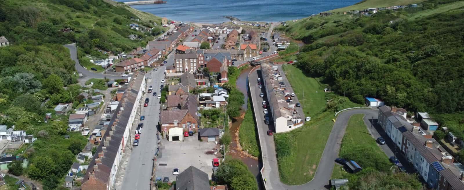
Skinningrove sits where Skinningrove Beck meets the North Sea, below a former ironstone-mining village on the Cleveland coast. Its flooding is fast and full of debris, which is exactly the problem the new scheme is built to solve.
The scheme swaps gates that have to be shut at short notice for a bridge built high enough that floodwater runs beneath it, protection that holds whether or not anyone is there to work it.
What is the Skinningrove flood alleviation scheme?
It is an Environment Agency flood defence project for Skinningrove in Redcar and Cleveland, built with the borough council. The Environment Agency confirmed in August 2026 that construction had begun, with completion expected in 2028. The aim is straightforward: give the village lasting protection that does not depend on someone closing a gate as the storm arrives.
- Investment: £13 million, led and largely funded by the Environment Agency.
- Homes protected: more than 100 in the village.
- Delivery: the Environment Agency with Redcar and Cleveland Borough Council; main contractor BAM.
- Completion: 2028.
- Core work: a new road bridge between New Company Row and Zetland Row, replacing the gated Stone Row Bridge.
The scheme is one small part of a much larger national effort. The Environment Agency has £1.4 billion for flood defences in 2026/27, inside a £10.5 billion commitment running to 2036, and the government reckons every £1 spent on flood defences saves around £8 in economic damage. Skinningrove is what that spending looks like on the ground in one village.
Why Skinningrove floods: Kilton Beck, Whitecliff Beck and the 2000 floods
Skinningrove Beck is fed by two watercourses above the village, Kilton Beck and Whitecliff Beck, which drain the moorland and farmland behind it. When it rains hard, the becks rise fast and bring trees and debris down with them. The Environment Agency describes the beck's behaviour as flashy and often unpredictable, and that is the whole difficulty: there is very little warning.
The event everyone remembers is 2000. After sustained rain in July, and again that November, debris jammed against a bridge near The Square, held the water back, and forced it out across the village. More than 100 homes and community buildings flooded. People were evacuated, and some were out of their houses for months while the clean-up dragged on.
The 2000 floods are the reason Skinningrove has the defences it has today: afterwards the council built flood walls along the beck and fitted the gates on the bridge that the Environment Agency now maintains.
The village response outlasted the water. Residents set up a volunteer river-warden scheme to keep an eye on conditions, and in 2012 a ceramic storywall went up at the Riverside Building to record what had happened. More than two decades on, this scheme is the permanent answer to the same weakness.
The problem with the current flood gates
The post-2000 defences work, but they lean on people. The main crossing, Stone Row Bridge, is protected by flood gates and demountable parapets that have to be raised and closed by hand as the beck comes up. That sounds manageable until you look at what it asks of the Environment Agency and the village during a storm:
- Timing is hard. A flashy beck gives little notice, so the gates often go in early and stay shut for long stretches, sometimes when the water never reaches them.
- Access gets cut. Closing the gates restricts vehicle access to Zetland Row and Grove Hill, so the defence that keeps the water out also shuts part of the village in.
- Blockage is a live risk. A low crossing is easy for debris to jam, the exact mechanism that turned heavy rain into a flood in 2000.
A defence that only works when it is operated correctly, under pressure, at short notice, is a defence with a built-in weak point. Removing that weak point is the point of the new design.
A new bridge that defends without gates
The scheme's answer is to raise the crossing so the gates are no longer needed at all. The existing flood gates, parapets and Stone Row Bridge come out, the gap in the flood wall is closed, and a new bridge goes in a short distance away, between New Company Row and Zetland Row, next to the Riverside Building. Its deck sits above the height of the flood wall.
Because the deck is above the wall, floodwater passes underneath without a gate to hold it back. The line of defence stays continuous, and it stays up on its own.
| Feature | Current Stone Row Bridge | New raised bridge |
|---|---|---|
| Flood defence | Manual gates and demountable parapets | Deck raised above the flood wall, no gates |
| Operation | Closed by hand as the beck rises | Passive; protects with nobody on site |
| Access during a flood | Restricted to Zetland Row and Grove Hill | 24-hour, uninterrupted vehicle access |
| Blockage risk | Low crossing can be jammed by debris | Higher deck reduces the risk of blockage |
| Pedestrians | Shared with the road | Separate footpath, built to the Equality Act 2010 |
Once complete, this scheme will deliver a genuine step-change in flood protection for the community of Skinningrove.
Andrew Turner, Flood Risk Operations Manager, Environment Agency
This is a different way of thinking about a defence. Rather than a barrier that someone has to operate correctly when it matters most, the protection is designed into the structure. Unda has written before about the other schemes taking this route, from the Romsey flood alleviation scheme on the River Test to the much larger Oxford flood alleviation scheme and the Guildford scheme now in consultation. Each is local in its detail; all share the same instinct to reduce how much a community has to do when the water rises.
Construction timeline: 2026 to 2028
The Environment Agency and BAM are building the scheme in two phases, so the village keeps a working crossing throughout.
- Phase 1 (September 2026 to late 2027): build the new bridge. Piled foundations, abutments and a crane compound near the Riverside Building, with a temporary access road kept open for Grove Hill residents while the work goes on.
- Phase 2 (December 2027 to early 2028): remove the old crossing. Once the new bridge is carrying traffic, Stone Row Bridge is demolished and the existing flood walls are infilled to complete the continuous line of defence.
Working hours are set to hold down the disruption: Monday to Friday 08:00 to 18:00, Saturday 08:00 to 13:00, no Sunday or bank-holiday working, and large deliveries timed to fall outside school hours. The Environment Agency's Skinningrove scheme page carries the drop-in dates and design updates as the work progresses. The recreation ground becomes the site compound and closes while the work is under way; the play park is reinstated with upgraded equipment once the scheme is finished.
There is a community strand too. The artist Mick Kirkby-Geddes has drawn up five options for the new bridge railings, each built on a local theme, the village bonfire, its murals, ironstone-mining heritage, the coastline, fishing and wildflowers, with residents voting on which one is built.
What it means if you live, buy or develop near Skinningrove
For residents, the gain is plain: fewer anxious gate closures, and a crossing that stays open when the beck is high. What the scheme does not do is redraw the flood map, and that catches people out.
The Environment Agency's Flood Map for Planning is drawn as if defences are not there. So a finished scheme usually will not move a property out of its mapped flood zone, even where it genuinely lowers the risk on the ground. We explain the reasoning in full in why you can still be in a flood zone after new defences are built: the scheme reduces the risk, it does not erase it, and a degree of residual flood risk always remains from a larger-than-design flood, a blockage or another source.
That distinction bites hardest at the planning stage: a site behind brand-new defences can still sit in Flood Zone 2 or 3, and still need a flood risk assessment.
If you are buying, extending or developing in or around the village, it is the flood zone, not the presence of the new bridge, that decides whether an assessment is required, and the Environment Agency's role as a statutory consultee does not change because a defence has been built. Unda prepares flood risk assessments across Yorkshire and the wider North East, including Middlesbrough and the Tees Valley, and can tell you quickly whether a site behind the Skinningrove defences needs one.
If you have a project on the Cleveland coast, or anywhere in a flood risk area, our flood risk assessment for planning service sets out exactly what your application has to show. Ask for a free, no-obligation quote and we will come back within 60 minutes.
Frequently asked questions
Who is paying for the Skinningrove flood alleviation scheme, and why is it starting now?
The £13 million comes mainly from the Environment Agency, working with Redcar and Cleveland Borough Council, within the government's wider flood defence funding programme. Timing is the reason it has taken until 2026: as recently as mid-2025 the design was funded but the money for construction was not confirmed. Securing that budget is what let the diggers move in.
Is Skinningrove at risk of flooding from the sea as well as the becks?
The scheme is aimed at flooding from Skinningrove Beck and the two watercourses that feed it. But the village sits right on the coast, at the mouth of the beck, so tidal and surface water risk are part of the picture too. The Environment Agency groups the local warning area under "coastal streams in Redcar and Cleveland". A site-specific assessment looks at every source, not the beck alone. Our guide to tidal and coastal flooding explains how the sea is mapped and assessed.
Will the new defences change my flood insurance?
Not automatically. Insurers tend to price from the same national flood datasets that keep the property in its mapped zone, so a completed scheme does not necessarily lower a premium even when it lowers real risk. It is worth telling your insurer the scheme exists, but expect the mapped flood zone, rather than the new bridge, to drive the quote.
Do I need a flood risk assessment to build or extend near Skinningrove?
If the site is in Flood Zone 2 or 3, yes, for any size of development, and regardless of the new defences. In Flood Zone 1 you will still need one if the site is a hectare or more, shows surface water risk, or is flagged in the council's strategic flood risk assessment. The new bridge does not remove that requirement.
What happens to the recreation ground and play park during construction?
The recreation ground is being used as the site compound and will be closed while the work is under way. The play park will be put back with upgraded equipment once the scheme is complete in 2028.
Latest news






One of our experienced Flood Risk Consultants will get back to you within 60 minutes