Why Is My House in a Flood Zone if It Has Never Flooded?
Estimated reading time 17 minutes
"Why is my house in a flood zone? We have lived here for years and it has never flooded."
Being never flooded but in a flood zone is not a contradiction, and it is not a mistake on the map. Flood zones are built from modelled flood probability, not from flood history. A house can sit in Flood Zone 3 having never taken water in living memory, because the designation describes the chance of flooding in any given year rather than a record of what has happened before.
That distinction sits behind almost every version of this question, and it matters most at two moments: when you check the Environment Agency map out of curiosity, and when a flood zone starts to affect a planning application, a sale or an insurance renewal.
The Flood Map for Planning is a forward-looking assessment of risk. It is not a historic flood record, so an empty flood history does not move a property out of a zone.
What does it mean if my house is in a flood zone?
In England, river and coastal flood risk for planning is mapped by the Environment Agency through the Flood Map for Planning (Rivers and Sea). It divides land into three flood zones by the statistical likelihood of flooding in any single year, ignoring the presence of flood defences. You can look up any address on the government's Flood map for planning service.
| Flood zone | Annual probability (rivers) | Annual probability (sea) | In plain terms |
|---|---|---|---|
| Flood Zone 1 | Less than 0.1% (below 1 in 1,000) | Less than 0.1% | Low probability |
| Flood Zone 2 | 0.1% to 1% (1 in 100 to 1 in 1,000) | 0.1% to 0.5% (1 in 200 to 1 in 1,000) | Medium probability |
| Flood Zone 3 | 1% or greater (1 in 100 or more) | 0.5% or greater (1 in 200 or more) | High probability |
These zones are produced by hydraulic flood modelling, which simulates how rivers behave during design flood events and how water spreads across the surrounding land. The Environment Agency sets out the same thresholds in its own flood zone guidance, and a fuller breakdown of each band sits in our guide to Flood Zones 1, 2 and 3 explained. The key point is that the map asks a hypothetical question about probability. It does not ask whether your specific house has ever had water through the door.
Why is my house in Flood Zone 3 if it has never flooded?
There are four common reasons a house appears in Flood Zone 2 or 3 with no known flooding history, and they usually apply in combination.
- Flood zones describe annual probability, not frequency. A "1 in 100 year flood" does not happen once a century. It means a 1% chance of that size of flood in any single year, so it can be absent for generations and still arrive next winter. Our explainer on flood return periods and annual probability sets this out in full.
- The modelling is strategic, not property-specific. Zones are mapped at catchment scale from topography, rainfall statistics and hydraulic flood modelling software. Small differences in ground level decide whether land falls inside or outside a modelled extent, so the map is a planning tool, not a guarantee about one plot.
- The map is drawn undefended. The Flood Map for Planning generally shows where water would go without flood walls, embankments or barriers in place, so the areas benefiting from defences are not carved out of it. A defended property can therefore sit in Flood Zone 3 even where protection is good in practice, a point we cover in why you can still be in a flood zone after new defences are built.
- Historic flood records are incomplete. Not every past flood was formally recorded or mapped. Older or smaller events may have no digital record at all, so the absence of a logged flood is not evidence that the risk is zero.
The mistake we see most often is treating the zone boundary as a survey line. It is not. It is the edge of a modelled extent drawn at catchment scale, and where that shading is holding up something you actually need to do, a site-specific flood risk assessment for planning tests your own ground levels, floor levels and access against modelled flood depths. It regularly puts a property in a better position than the zone alone suggested.
Never having flooded is fully consistent with a 1% annual chance. Over a lifetime in the property, "it has not happened yet" is exactly what a low but real annual probability looks like.
Does a flood zone mean my house will flood?
No. A flood zone is a probability band applied to land, not a forecast for your building. Flood Zone 3 means the land carries a 1% or greater annual exceedance probability of river flooding in a modelled event with the defences discounted, which says nothing at all about your floor levels, the standard of protection nearby, or when any flood might arrive. Most properties in a mapped flood risk area have never flooded.
The arithmetic is what surprises people. A 1% annual chance sounds negligible, but risk accumulates over time. Assuming the probability stays constant, a Flood Zone 3 property has roughly a one-in-four chance of at least one such flood over a 30-year mortgage, and around a 63% chance across the 100-year design life the planning system assumes for a new home.
Scale helps put that in proportion. The Environment Agency's National Flood Risk Assessment, published in December 2024, put around 2.4 million properties in England in areas at risk from rivers and the sea and around 4.6 million in areas at risk from surface water, 6.3 million once the overlap is counted once. By the middle of the century, with climate change, the assessment expects roughly 8 million, or about one property in four. That is the underlying data behind NaFRA2, and the great majority of those homes have never flooded. Being mapped is ordinary. It describes the company you keep, not the state of your building.
A flood zone tells you about probability over the years you own the house. It changes what you check, what you insure and what you disclose. It does not tell you the house is unsafe to live in.
What is the map actually measuring, flood risk or flood history?
The map and your experience are answering two different questions, and both answers can be true at the same time. The Flood Map for Planning measures modelled flood risk: if a flood of a defined probability occurred, where would the water reach? Your memory measures flood history: has water actually entered this house in the years you have known it? A property can be a genuine "no" on the second question and still fall inside a modelled extent on the first.
What the flood map asks
"If a flood of this probability happened, where would the water go?"
Based on: modelled probability, topography and rainfall
Time frame: any given year, looking forward
For your house: it lies within a modelled flood extent
What we tend to assume
"Has this house actually flooded before?"
Based on: personal memory and local recollection
Time frame: the years you have known it
For your house: not in living memory
Confusing the two is the single most common misread of a flood map, and it cuts both ways. A house that has flooded can map as lower risk than expected, and a house that has never flooded can map as Flood Zone 3. Our note on whether flood maps are accurate works through why the two diverge. It is also why surface water matters here: a property well away from any river, sitting comfortably in Flood Zone 1, can still be in a surface water flood risk area, because the Flood Zones cover rivers and the sea only. Our guide to the types of flooding and sources of flood risk covers the rest.
How can I check whether my house is in a flood zone?
You can confirm your flood zone yourself in a few minutes, using free government and Environment Agency data. Two different services answer two different questions, so it is worth checking both.
- For the planning flood zone, search your address on the government's Flood map for planning service. This returns the Flood Zone 1, 2 or 3 classification that councils use to decide applications.
- For everyday, all-sources risk, use the Environment Agency's Check for flooding service, which covers rivers, the sea, surface water and reservoirs, and includes live flood warnings. The longer-term picture sits on the government's check the long term flood risk service.
- To see both at once, our free flood risk map, check flood risk by postcode reports the planning flood zone and the long-term risk picture side by side, with a downloadable summary.
One caution: the everyday "long term flood risk" service is not the same as the Flood Map for Planning and cannot be used to support a planning application. We explain the difference in why you can't use the long term flood risk map for planning.
Mapped in a flood zone with no flood history?
Send us your postcode and we will tell you free of charge, usually within the hour, whether an assessment is likely to be required.
Get a free checkHow do I find out whether my house has flooded before?
Flood history is harder to establish than flood risk, because no single record is complete. Start with the seller's information on a purchase, the Environment Agency's historic flood outlines, local newspaper archives and neighbours' recollections. Then read the result carefully. A blank search means "no record found", which is not the same as proof of safety, because minor and older events frequently go unrecorded.
- The Environment Agency's open data. The Historic Flood Map and the Recorded Flood Outlines dataset are both published openly and show where flooding has been formally recorded from rivers, the sea and groundwater.
- The seller's disclosure. On a purchase, the TA6 Property Information Form asks the seller directly about flooding, and what your conveyancing solicitor does with that answer is narrower than most buyers assume.
- Section 19 investigation reports. Where a significant flood has happened, the Lead Local Flood Authority may have published an investigation report naming the affected area.
- Local memory and local press. Newspaper archives and neighbours routinely hold events that never reached a national dataset, particularly from before digital record-keeping.
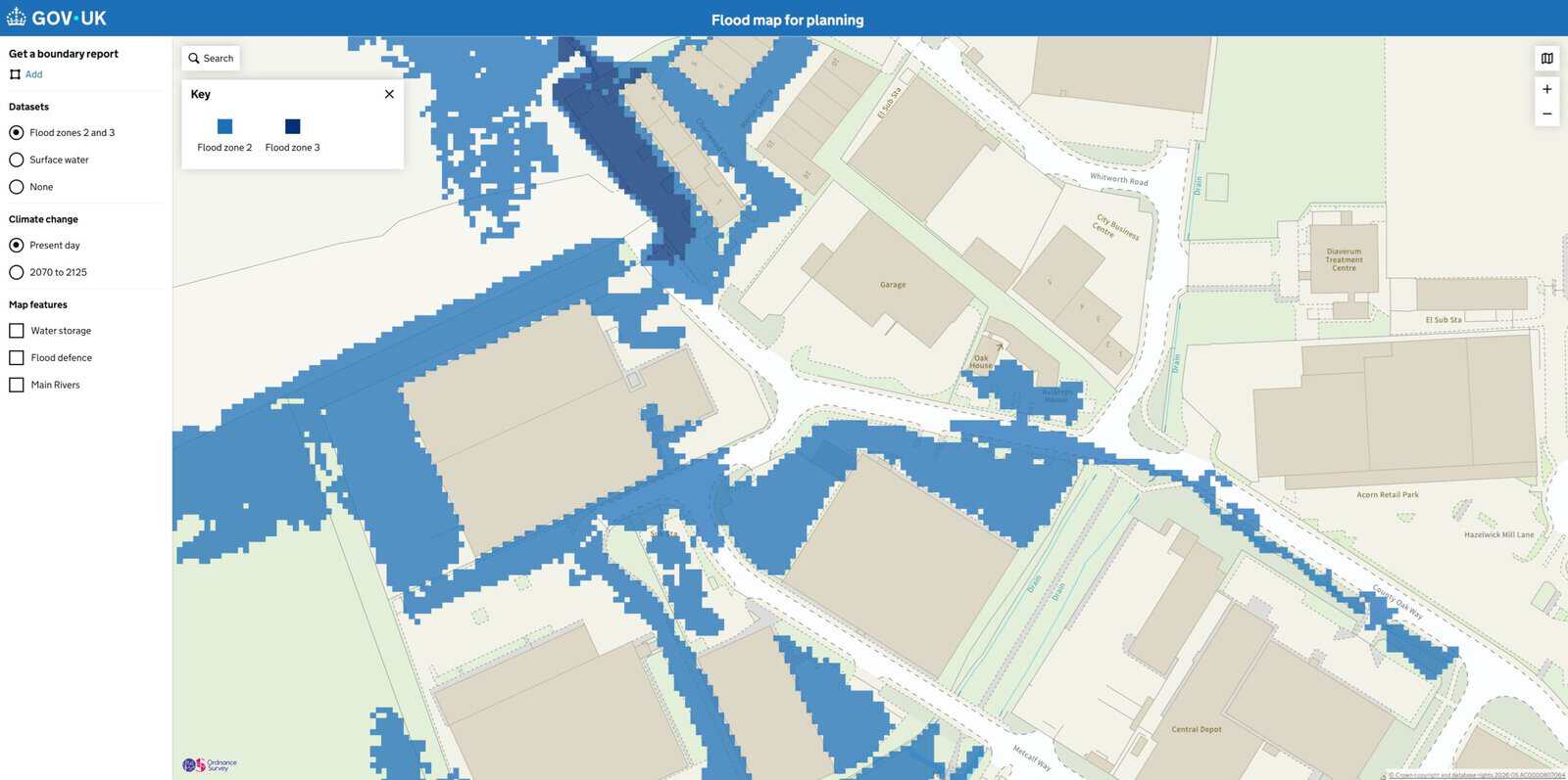
The Flood Zones data shows the extent of land at present day risk of flooding from rivers and the sea, ignoring the benefits of defences.
Environment Agency, Flood Map for Planning dataset (gov.uk)
If you are selling, flood history is also something you may need to disclose, which we cover in flood history declarations when selling a property. Either way, the map's zone and the property's history are separate pieces of evidence, and a full assessment weighs both.
What does being in a flood zone mean for planning permission?
Flood zones do most of their work in the planning system. They guide how Local Planning Authorities apply national policy when deciding where development should go, alongside the government's planning practice guidance on flood risk and coastal change. If your site is in Flood Zone 2 or 3 and you are proposing an extension, a replacement dwelling, a change of use or new homes, a Flood Risk Assessment is normally required.
- A Flood Risk Assessment refines the strategic map. It uses site-specific ground levels, modelled flood depths, defence standards, safe access and mitigation to show how development can proceed safely, often a clearer picture than the zone shading alone.
- Some proposals also face the Sequential and Exception Tests. Depending on the vulnerability of the development, national policy may require it to pass the Sequential and Exception Tests before permission is granted.
- Climate change is built into the assessment. An FRA applies the Environment Agency's climate change allowances, so it looks at future risk over the lifetime of the development, not just today's map. We cover how they apply in NPPF flood risk climate change allowances for planning.
If you are unsure whether your project needs one, our guide to when you need a Flood Risk Assessment covers the triggers.
What the August 2026 NPPF changed
The National Planning Policy Framework published on 17 August 2026 reorganised flood risk policy rather than rewriting the science behind it. Flood risk now sits in a dedicated Chapter 18 with nine coded policies, F1 to F9, while the flood zone definitions and the vulnerability classification have moved into a new Annex F, which is where an agent or planning officer will now go looking for them. The zones themselves are unchanged. So is the reason a never-flooded property can sit in Zone 3.
Two changes are worth knowing if a flood zone is holding up an application. The policy language is now worded around refusal, which raises the cost of a weak or generic assessment, and the 2025 National Standards for Sustainable Drainage Systems became mandatory through Policy F8. Our summary of the August 2026 NPPF flood risk and drainage changes sets out where each old paragraph moved to, and the earlier explainer on planning for flood risk under the NPPF still covers the underlying approach.
The August 2026 NPPF moved the flood zone definitions into Annex F and put flood risk in Chapter 18. Applications already in the system are being decided against the new wording.
What if I am buying, selling or insuring the property?
Outside planning, a flood zone mainly shapes conveyancing, lending and insurance. It is rarely a dealbreaker, but it is worth understanding before it appears in a search result or a renewal letter. The pattern is the same in all three: the flag is generated from a postcode-scale band, and what moves it is evidence about your building.
| Situation | What the flood zone does | What actually helps |
|---|---|---|
| Buying or borrowing | Triggers a flag on an environmental search and, occasionally, a lender query | A site-specific assessment of your floor and ground levels, rather than a broad screening band |
| Selling | Feeds the TA6 flooding disclosure and any buyer's search result | An accurate flood history and a clear account of what the zone does and does not mean |
| Insuring | Can influence the premium, the excess and which insurers will quote | Property-level evidence, plus Flood Re eligibility for most pre-2009 homes |
We cover the lending side in flood risk and mortgage lending and the market side in does flood risk affect house prices. For buyers, an independent, site-specific assessment often shows a lower real risk than a broad "high risk" screening suggests, because it examines your actual floor and ground levels rather than the postcode area. That is the purpose of a flood risk assessment when buying a house. If you are earlier in the process, checking flood risk before buying a property explains what to look for.
On insurance, most UK homes built before 1 January 2009 remain eligible for Flood Re, the government-backed reinsurance scheme that keeps flood cover affordable, and our guide to what Flood Re is sets out the eligibility rules. Where an insurer has priced on a mapped band rather than on your building, a flood risk assessment for insurance gives you something specific to put back to them. A clean flood history on its own rarely shifts a premium. Floor levels, thresholds and a defence standard usually do.
If you believe the zone boundary itself is wrong, the Environment Agency does run a formal challenge process, which we cover in the EA flood map challenge.
If a flood zone is affecting a planning application, a purchase or an insurance position, early technical advice usually clarifies what the mapping means for your property and whether a proportionate Flood Risk Assessment is needed. Unda prepares Flood Risk Assessments for planning across England and Wales, and independent assessments for homebuyers where a search or lender has raised flood risk.
Still unsure what your flood zone means?
Our consultants will read the mapping against your actual floor and ground levels, and tell you what it changes for a planning application, a purchase or an insurance renewal.
Speak to UndaFrequently asked questions
Can I get my property's flood zone changed if I think it is wrong?
Sometimes. The Environment Agency has a formal process to review and, where justified by better local data, amend flood zones. It usually needs site-specific evidence such as detailed ground levels or updated modelling.
Is Flood Zone 1 completely free from flood risk?
No. Flood Zone 1 only describes low probability of river and sea flooding. It says nothing about surface water (pluvial) flooding, which is now the most widespread source of flood risk in England and can affect properties well away from any river. A Flood Zone 1 site over one hectare, or one with mapped surface water risk, can still need a Flood Risk Assessment.
Why is my house a different flood zone from the one next door?
Because the modelling is sensitive to ground level. A difference of a few tens of centimetres in elevation, or being a little further from the watercourse, can place one property inside a modelled flood extent and its neighbour outside it. This granularity is exactly why a site-specific assessment can refine the strategic map.
Do I need a flood risk assessment if I am not building anything?
Not for planning. An FRA for planning is triggered by a development proposal, not by ownership. But homeowners often commission an independent assessment for a purchase, a mortgage query or an insurance dispute, where the goal is to understand actual risk to the building rather than to satisfy a council.
Will my flood zone change the next time the maps are updated?
It can. The Flood Map for Planning is revised as better modelling and survey data become available, and a property that has never flooded can move between zones on a data change alone. The Environment Agency paused its regular update cycle in August 2026 while new processes are put in place, so the current mapping is likely to stand for longer than usual.
Does the Flood Map for Planning show surface water risk?
It does now, in part. In May 2026 the Environment Agency added surface water climate change extents and banded depth layers to the service, using the upper-end 2070s allowance, as we set out in our note on the May 2026 Flood Map for Planning update. The Flood Zones themselves still cover rivers and the sea only, so a Flood Zone 1 property can carry real surface water risk.
About the author. Edward is a co-founder and Director of Unda with 20+ years in flood risk and drainage, and a national-press commentator on flooding. Unda has been trading since 2014, is a CIWEM Business Partner with CIWEM member and chartered (C.WEM MCIWEM) consultants, and has delivered 5,000+ flood risk assessments and drainage strategies across England and Wales.
Edward Bouët · BSc (Hons)
Latest news






One of our experienced Flood Risk Consultants will get back to you within 60 minutes