Flood control without gates: how the Dujiangyan irrigation system has worked for 2,280 years
Estimated reading time 25 minutes
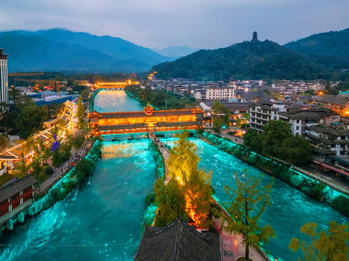
The Dujiangyan irrigation system is a flood control and irrigation scheme on the Min River in Sichuan that has been running since the third century BC, and it does its job without a dam across the river, without stored head, and without a single gate in the original works. Every control is a shape rather than a decision. A levee splits the river. A weir sited on the wrong bank on purpose throws the sediment back out. A channel cut through a mountain limits the flood peak because it physically cannot admit more than a set discharge. Nobody has to be awake for any of it.
The scheme now heads the water supply for roughly 770,000 hectares of Sichuan farmland and more than 30 million people, about four times the area it served when the People's Republic was founded.
That is the part worth a British drainage engineer's attention, and it is also the part almost every English-language account gets wrong. This article is written from the modelling literature, the World Heritage nomination file and the post-earthquake damage record rather than from tourist copy, and it concedes what that copy leaves out, including that the modern scheme has a 156-metre dam four kilometres upstream and an electrically operated sluice gate that has set the flow split since 1974. It is the third in a run on the history of drainage, after Roman drainage and flood management and medieval drainage.

Who built the Dujiangyan irrigation system, and why?
The Dujiangyan irrigation system is credited to Li Bing, the Qin governor of Shu, in the third century BC. He was solving two problems on one river: the Min flooded the land at the foot of the mountains, and left the Chengdu Plain beyond Mount Yulei dry, because the ridge stood between the water and the ground that needed it. The Min comes off the eastern edge of the Tibetan Plateau steeply and carries a heavy bed load.
The primary source is thinner than the retellings suggest. Sima Qian's Records of the Grand Historian names only "Bing, governor of Shu", says he cut through Lidui and drove two rivers through Chengdu, and lists navigation first with irrigation as the use for the surplus. It gives no construction date, no completion year and no son. The 256 BC start that appears everywhere is a modern convention taken from his tenure rather than a date in any received text, and Li Bing's celebrated son belongs to cult and folklore rather than to history.
A dam was never the answer here, and the reason goes beyond what the Qin could build. A dam on the Min would have impounded the sediment along with the water, and the plain needed a controlled share of the flow all year, not a reservoir slowly filling with gravel. What Li Bing's people built instead was a diversion headworks in three parts, each doing one job by virtue of its shape.
How does the Dujiangyan irrigation system work?
The Dujiangyan irrigation system splits the Min into two channels with a mid-stream levee, lets a weir on the inside of the resulting bend throw the sediment-laden bottom water back into the river it came from, and admits the cleaner surface water to the plain through a fixed-section rock cut that acts as a throttle. There is no impoundment, no stored head, and in the original arrangement nothing to open or close. The UNESCO World Heritage inscription describes it as solving diversion, sediment removal and flood control "without the use of dams".
The three works sit within about 830 metres of each other. The fish mouth levee, Yuzui, divides the flow. Seven hundred and ten metres downstream the flying sand weir, Feishayan, sits on the convex bank of a slight bend in the inner channel. A further 120 metres on, and on the opposite, concave bank, is Baopingkou, the bottleneck: a channel roughly 20 metres wide at working level, hand-cut through the ridge. The order matters, the distances matter, and which bank each element sits on matters most of all. Letting the layout do the work that would otherwise fall to a decision is the same instinct behind a surface water drainage strategy that designs for sediment from the start rather than bolting on a silt trap once the layout is fixed.
The fish mouth: a flow split that changes itself
Yuzui is a boat-shaped levee sited at a bend, standing five to eight metres above the river bed, about 30 metres wide at the top and 140 metres at the base. It divides the Min into an outer channel, which stays the river, and an inner channel, which feeds the plain. The interesting part is that the proportion going each way changes with stage, and nothing moves to make that happen.

The mechanism is a mid-channel shoal and the levee's own crest level. At low flow the shoal is emergent and the split favours the inner channel, which is what the plain needs in the dry season. As the river rises the shoal drowns out and an increasing share goes down the outer channel. That is the behaviour a flood defence wants, and the opposite of what a fixed proportional split gives you.
- Low flow, dry season. The mid-channel shoal stands proud and steers the greater share into the inner river, where the plain needs it for irrigation. Traditionally described as more than 60 per cent.
- Rising stage. The shoal begins to drown out. The inner share falls progressively as the outer channel takes an increasing proportion, with no intervention and no threshold to miss.
- Flood. The main current runs straight into the outer river and the inner share drops below 40 per cent. Whatever the inner channel does take, Feishayan and Baopingkou downstream then limit.
Treat the "four–six" ratio as a description of the pre-modern scheme rather than a measurement of today's. The numerical modelling published in Sustainability in 2020 reproduces the historically measured diversion ratios well, but at around 50 per cent at 800 cubic metres per second and around 44 per cent at 1,800, not 60 and 40. The same paper records that after a check gate was built across the outer river in 1974, the measured share going to the inner river was close to 75 per cent in spring and only 37.5 per cent in the flood season. That is a wider swing than the geometry ever produced, because a gate now sets it.
A 2024 study in Hydrological Processes found that under today's regulated conditions the fish mouth splits the water roughly equally, while sending only about 20 per cent of the bed load down the inner channel against 80 per cent down the outer.
The flying sand weir: designed to throw silt back out
Feishayan is a low, long weir, about 240 metres of it, standing roughly two metres above the inner river bed. Its entire purpose is to eject sediment. It is the element with no real counterpart in ordinary British drainage design, because it treats siltation as the design case rather than as something that happens to the scheme afterwards.
The trick is the bend. Water going round a curve develops a secondary, helicoidal circulation: the surface water is thrown to the outside of the bend, and the bottom water, which carries the suspended load and the bed load, migrates to the inside. Feishayan sits on the convex bank, where the dirty bottom water goes. Baopingkou sits 120 metres further on and on the concave bank, where the clean surface water goes. The weir crest is low enough that once the inner river exceeds about 500 cubic metres per second, the sediment-charged layer simply passes over it and back into the outer river.
- The split at the fish mouth does the first sort. Roughly 26 to 29 per cent of the Min's bed load enters the inner river at all; the rest stays in the outer channel. It is source control, two thousand years early.
- The weir does the second. Zhang and colleagues reported in the Journal of Hydraulic Engineering in 2013 that Feishayan discharges more than 90 per cent of the bed load entering the inner river back to the outer river.
- What reaches the intake is nearly clean. Cao and colleagues reported in 2010 that less than 8 per cent of the Min's total sediment reaches Baopingkou.
- Both figures are routinely misattributed. They are quoted in the 2020 modelling paper's introduction and are not findings of that paper. If you have read that a study "found" 90 per cent, you have read a game of telephone.
- The two percentages measure different things. One is a proportion of the bed load already inside the inner channel; the other is a proportion of the whole river's sediment. Quoting either as "90 per cent of the silt" collapses the distinction.
The bottleneck: flood protection by fixed geometry
Baopingkou is the flood defence, and it is a hole in a mountain. Li Bing's people cut it through the Yulei ridge by fire-setting and water-quenching, heating the rock and cracking it with cold water, because iron tools were not available in the quantity the job needed. The World Heritage file gives the cut as about 36 metres long, 28.9 metres wide at the top and 18.8 metres deep; the working throat at water level is nearer 20 metres.
Because the section is fixed in bedrock, the discharge it can admit is fixed too. Once the inner river brings more water than the cut will take, the surplus has nowhere to go but back up the channel, since the conveyance downstream is capped, and over Feishayan into the outer river. The weir is not a spillway someone opens in an emergency. It is the only thing the surplus can do, and it happens at the same stage every time, whether the flood arrives at three in the afternoon or three in the morning.
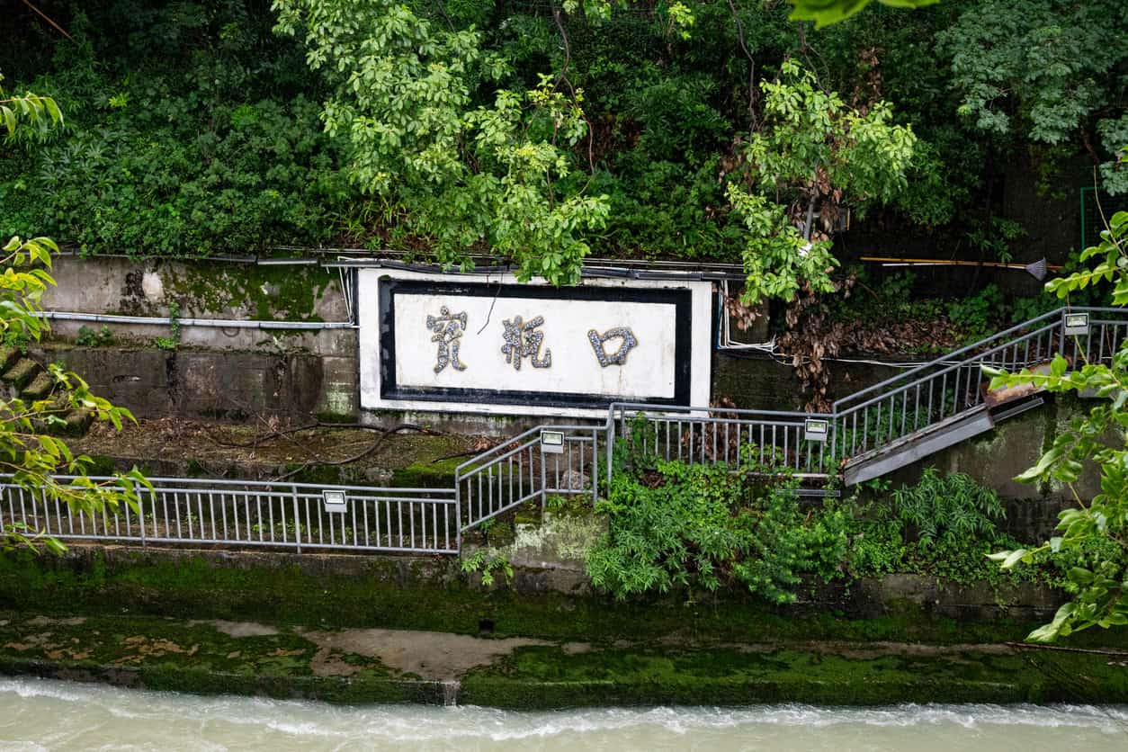
In Shu, Bing, Governor of Shu, cut through Lidui, averted the harm of the Mo river, and drove two rivers through the midst of Chengdu … where there was surplus, it was used for irrigation.
Sima Qian · Records of the Grand Historian, Treatise on Rivers and Canals, c. 91 BC
That is a hydraulic throttle, and the principle is entirely familiar in Britain. It is what a flow control does at the outlet of an attenuation basin, and what an ungated spillway does on a reservoir. The Environment Agency's own spillway design guide states plainly that gated spillways are rarely used in the UK, and that where they are used the benefits are offset by needing a power supply and by having to manage the risk of abnormal gate operation through redundancy, surveillance and maintenance. The same thinking is what separates a surface water drainage strategy that treats sediment and maintenance as design cases from one that leaves both to be discovered after handover.
Dredge the shoal deep, build the weir low
Six characters govern the maintenance of the Dujiangyan irrigation system: 深淘滩、低作堰, or dredge the shoal deep, build the weir low. It is inscribed at the Erwang Temple above the works, and it is a better maintenance specification than most British drainage schemes ever receive, for one reason. It is a two-sided tolerance, not an instruction to dig as much as you can.
The datum is physical. Four iron bars, the wotie, are buried in the river bed at the Fengqiwo section. The oldest dates from about 1576, in the Ming dynasty; the newest was laid in 1994. Each is roughly four metres long, and their tops sit about 1.8 metres above the surrounding bed. The annual winter dredge goes down until the bars are exposed, and then it stops.
Dredging shallower than the iron bars lets sediment keep accumulating; dredging deeper than them lowers the erosional base level and starts scouring the bed. The bars define a bed profile at which erosion and deposition balance across a year.

The second half of the maxim is the weir. Keeping Feishayan low preserves its ability to shed sediment in flood; raise the crest for a little more dry-season diversion and you lose the mechanism that keeps the intake clear.
The original fabric supported this. Bamboo gabions filled with cobbles and macha timber tripods were cheap enough to be replaced annually, and were expected to be. Sacrificial components with a published replacement cycle, in other words, and a survey datum to replace them to.
That is more than most British schemes manage when the question of who maintains a local flood defence comes up, which is what CIRIA C821 was published in March 2026 to address.
Did the Dujiangyan irrigation system survive the 2008 earthquake?
Partly, and the honest version of the story is more useful than the triumphant one. The Wenchuan earthquake of 12 May 2008 was magnitude 7.9 on the USGS scale and Ms 8.0 on the Chinese one, with an epicentre between 20 and 27 kilometres from the works depending on whose location you take, and only about 13 kilometres from Yingxiu, where the surface rupture began. Shaking at Dujiangyan reached intensity IX to XI. This was not a marginal test.
| Element | Type | Outcome |
|---|---|---|
| Yuzui, the fish mouth | Ancient work, rebuilt 1974 | Several longitudinal cracks; 1 m of settlement and a crack over 1 m wide at the right-bank sidewall junction. Repaired by 21 May. |
| Feishayan, the flying sand weir | Ancient work | Barely affected. |
| Baopingkou, the bottleneck | Rock cut | Barely affected. |
| Outer river check gate | Modern, 1974 | Sidewall cracked and settled; hoist beam and control room needed emergency repair. |
| Erwang Temple | Timber-framed buildings, not hydraulic | Close to 90 per cent of the ancient buildings lost; 110 million yuan restoration, reopened 2011. |
| Zipingpu dam, 4.8 km upstream | Modern, 2006 | Up to 800 mm crest settlement and a 17 cm face-slab dislocation, a damage mode not previously recorded on that dam type. It held. |
Diversion was never lost. Emergency works began on 16 May and the fish mouth repair finished on 21 May, nine days after the earthquake. In the meantime the administration rerouted flows to keep Chengdu's No. 6 waterworks running.
Two things routinely get folded into this story that do not belong in it. The Erwang Temple is a timber-framed complex on the hillside above the works, not a hydraulic structure. Zipingpu is a modern dam whose behaviour says nothing about Li Bing. It is worth noticing, though, that had Zipingpu failed, the fish mouth's survival would have been beside the point. Whether the reservoir's own load helped trigger the earthquake is argued in the literature and argued against. The modelled stress changes run from mildly stabilising to strongly destabilising, and the spread is driven by modelling choices rather than by data.
What gets said about Dujiangyan that is not true
The Dujiangyan irrigation system attracts more confident nonsense than any other piece of ancient water engineering, and correcting it is most of the reason this article is worth writing. Five claims, in rough order of how often they turn up in British coverage.
- It is not the world's oldest dam. It is not a dam at all and impounds nothing, which is the point of it. The oldest known dams are at Jawa in Jordan, around 3000 BC, and Sadd el-Kafara in Egypt, around 2600 BC.
- It is not unchanged. ICOMOS put it plainly when recommending inscription: the authenticity lies in the conception and design, and modern materials have been used. The present headworks are a 1935–36 rebuild after an outburst flood destroyed the originals in 1933, and the fish mouth was rebuilt in reinforced concrete and shifted west in 1974.
- It is not the world's oldest irrigation system. Canals at Choga Mami in Mesopotamia date from around 5500 BC. Even within China the Zhengguo Canal was begun a decade earlier. The qanats of Gonabad in Iran, dug between 700 and 500 BC, are older still and remain in use.
- It is not gate-free today. An eight-bay electrically operated check gate went across the outer river in April 1974 and now sets the diversion ratio, the 156-metre Zipingpu dam has regulated the flow from 4.8 kilometres upstream since 2006, and the scheme is run through a digital twin with 59 instrumented gates.
- Sponge cities are not a rediscovered ancient idea. The techniques are old and international; the policy is a Chinese national programme of 2013 to 2015, given intellectual shape by the landscape architect Kongjian Yu, who died in 2025. The honest account of what it means here is in our piece on sponge cities in the UK.
One more deserves its own paragraph, because British readers meet it constantly. The claim that Ganzhou's Song-dynasty Fushou Gou drains have kept that city flood-free for a thousand years is repeated in UK coverage as settled fact. Ganzhou's own gazetteers record around twenty inundations between 1036 and 1800. Liu Yi's authorship is a hedged Ming-era gloss: the contemporaneous Song source credits him only with the flap-valve outlets, and the Ming gazetteer says outright that nobody knows which dynasty built the drains. Roughly one to two kilometres of a twelve-and-a-half-kilometre network survives. The old city's resilience owes as much to sitting on a convex spur above a confluence, behind a Song brick wall that still does flood-defence work, as it does to the drains. The engineering is real and interesting. The millennium is not.
What a UK drainage engineer should take from it
Not "build it like the Qin". The read-across is narrower, and it holds in three places: passive control over operated control, sediment as a design case, and sacrificial components with a datum to replace them to.
| The principle | At Dujiangyan | In UK practice |
|---|---|---|
| Fixed-geometry throttle | Baopingkou: a fixed section in bedrock, so a fixed maximum admission | Orifice plates and vortex flow controls at a basin outlet; ungated spillways, which the Environment Agency describes as the UK norm |
| Defence by height, not by operation | Every control set by crest level and cross-section | The Skinningrove flood alleviation scheme: a bridge deck set above the flood walls with freeboard to spare, replacing hand-closed gates |
| Sediment removed by geometry | Feishayan on the convex bank, ejecting the bed layer before the intake, as a sediment pond does at an inlet | Forebays and first-flush pre-treatment ahead of storage: see first flush in SuDS and the Loughborough sediment pond research |
| Sacrificial components | Bamboo gabions and timber tripods, replaced annually by design | Fuse plugs and designed overtopping onto erosion-resistant surfaces; leaky dams in natural flood management |
| A maintenance datum | Four iron bars fixing the bed level the annual dredge works to | CIRIA C753's fixed sediment depth marker in a forebay: specified, and rarely installed |
| Surplus routed, not stored | Flood surplus backs up and spills over Feishayan into the outer river | Level-for-level compensatory storage and floodplain flow routes kept open |
Passive beats operated, and the Environment Agency has quantified by how much. Its guidance on temporary and demountable flood protection works out the reliability of an operated defence as the product of four probabilities: forecast, alert, mobilisation and closure. Its worked example gives 0.95 × 0.99 × 0.98 × 0.90 = 0.83. A defence worth two million pounds of benefit if it were permanently in place is worth £1.66 million as a demountable. The guide caps overall operational reliability at 90 per cent as a matter of policy, and says that where a permanent system is technically, economically and environmentally feasible it should be built instead. That is Baopingkou's logic, written down in Bristol in 2011.
It is also why the Agency is spending £13 million at Skinningrove, replacing a bridge with hand-closed flood gates with one whose deck sits above the flood wall. Construction began this month and finishes in 2028. The Agency's stated reason is the catchment: the beck is flashy and unpredictable, so the operating window is too short to depend on.
Sediment is a design case with numbers attached. CIRIA C753 gives worst-case silt loads by catchment type: 723 kilograms per hectare per year from highways, 840 from commercial development, 755 from high-density residential. Over fifty years that costs up to 8.5 per cent of the storage. It asks for a forebay of at least 10 per cent of the basin's plan area and, in a detail Li Bing would have recognised, for a fixed sediment depth marker where high loads are expected. A datum to dredge to. On most British sites nobody installs one, and it surfaces later as a maintenance problem nobody owns.
Sacrificial is a legitimate design choice, and Britain already uses it. The Agency's spillway guidance names fuse plugs, deliberately sacrificial embankments, as a reservoir control option alongside gates, and treats designed overtopping onto erosion-resistant surfaces as standard practice. It is the same instinct behind natural flood management and behind nature-based drainage in modern planning. What Dujiangyan adds is the discipline: a component expected to fail, an annual replacement cycle, and a datum that says when the job is done.
Britain has the standards and struggles with the follow-through. The 2025 National Standards for sustainable drainage, published by Defra in June 2025, ask for sediment controls that can be emptied easily, safe access for the plant that maintains them, and designs that minimise energy use, including pumping. The NPPF as revised in August 2026 makes those standards a planning requirement. Adoption is what is still missing: Schedule 3 of the Flood and Water Management Act 2010 remains uncommenced in England, so there is no SuDS Approving Body and who maintains the asset is decided site by site. The Environment Agency meanwhile reported 93 per cent of its high-consequence flood assets at required condition in April 2026, against its own view, given to the Public Accounts Committee, that best value comes at 98 per cent.
The honest limit of the analogy: Dujiangyan had a whole river to work with, a headworks corridor measured in hundreds of hectares, and a state prepared to fund an annual dredge for two millennia. A 1.2-hectare housing site in Sussex has none of those, and the surface water flooding it has to manage arrives in minutes rather than over a monsoon. The transferable part is the attitude, not the arrangement.
So the fair summary is this. The alignment, the three-element logic, the use of the bend and the maintenance discipline are ancient. The fabric is not, and the flow regime is now actively controlled. The Dujiangyan irrigation system is a 2,280-year-old idea maintained continuously, which is a better thing to be than an unchanged ruin, and a more useful model, because continuous maintenance is something a British scheme can copy. If you are designing something that has to work when nobody is watching, that belongs in the drawings rather than in a manual nobody reads. We can help with the drainage strategy for your planning application, and with a flood risk assessment for planning where the site needs one.
Frequently asked questions
Why do modern flood schemes still use gates if fixed geometry is more reliable?
Because gates buy things geometry cannot. They give flexible control across a wide range of flows, they let one structure serve navigation and flood defence at once, and they need far less land, since a fixed-crest solution usually needs somewhere to spill into and in a town there often is nowhere. The Thames Barrier is the fair counter-example: 221 flood closures to November 2025, and it works because it has a 36-hour forecast window, a permanently staffed control room, a named duty controller and a maintenance allowance of no more than 50 closures a year on average. That operating model does not scale down to a flashy beck, and it is expensive to sustain: the River Thames Scheme delays show how hard operated infrastructure is to deliver on time. The counter-case is York in December 2015, where water reached the Foss Barrier's pumping station through a construction joint and an access cover left open for a mobile pump, and staff had to raise the barrier; the independent investigation is worth reading on how many things an operated defence depends on at once.
Are there passive flood defences like this in the UK?
More than people expect. Ungated spillways are the norm in British reservoir practice rather than the exception. Vortex flow controls and orifice plates are fixed-geometry throttles doing Baopingkou's job at the outlet of an attenuation basin, and they sit inside the SuDS discharge hierarchy as a matter of routine. At Alkborough Flats on the Humber, 1,500 metres of old flood embankment were deliberately lowered to act as a weir alongside a 20-metre breach, so the site fills and empties with the tide and cuts extreme levels in the upper estuary by more than 150 millimetres with nobody operating anything.
What would a maintenance datum look like on a UK drainage scheme?
CIRIA C753 already asks for one: a fixed sediment depth marker set in the forebay where high sediment loads are expected, with the forebay base reinforced so the silt can be dug out without damaging it. That is functionally a wotie. What is usually missing is the second half of the specification: a stated frequency, a named owner and an access route wide enough for the plant that does the work. The 2025 National Standards require free, safe and easy access for the personnel, vehicles and machinery that maintenance needs, which is the same point made from the other end. Getting both into a scheme that has to deliver on all four SuDS pillars is largely a matter of deciding it early enough to affect the layout.
How often does a UK attenuation system actually need desilting?
CIRIA C753's schedules put forebay sediment removal at every one to five years, and the main body of a pond without a forebay at about every five years. Where effective upstream pre-treatment is provided, the manual says the main body may only need it every 25 to 50 years. The spread between those figures is almost entirely a function of whether sediment was designed for at the inlet or left to arrive at the storage, which is the same choice Feishayan makes 120 metres upstream of the intake. C753 is also candid that well-designed systems with a proper management train rarely suffer rapid silt accumulation at all; the trouble concentrates in end-of-pipe storage with no source control ahead of it.
About the author. Edward is a co-founder and Director of Unda with 20+ years in flood risk and drainage, and a national-press commentator on flooding. Unda has been trading since 2014, is a CIWEM Business Partner with CIWEM member and chartered (C.WEM MCIWEM) consultants, and has delivered 5,000+ flood risk assessments and drainage strategies across England and Wales.
Edward Bouët · BSc (Hons)


One of our experienced Flood Risk Consultants will get back to you within 60 minutes
