Nine hours of warning: the 1953 North Sea flood and the failure that killed 307 people

Estimated reading time 20 minutes
The 1953 North Sea flood killed 307 people in England on the night of Saturday 31 January and the morning of Sunday 1 February. It remains the deadliest natural disaster in modern British history. Sea defences failed in 1,200 separate places along more than 1,600 km of coast, 24,000 properties were badly damaged and over 30,000 people were driven from their homes.
What is less often said about the North Sea flood of 1953 is that the water was not a surprise. It was observed. The first English breach came at Spurn Head in the afternoon; Canvey Island was not overwhelmed until after midnight. Roughly nine hours separated the two. What did not travel down the coast in those nine hours was the warning.
A flood with nine hours of lead time still killed 307 people, because in 1953 nothing existed to carry an observation from one end of the coast to the other.
That is the part of the story a flood risk consultancy is best placed to tell, and it is the part that still shapes how safe access, refuge and warning are assessed today.
What caused the 1953 North Sea flood?
A deep depression, a spring tide and a long northerly fetch arrived together. The low developed south of Iceland on 29 January, deepened to about 964 hPa, tracked north of Scotland and then turned south-east into the North Sea rather than running on east. Water was driven ahead of it into the narrowing southern basin, on a tide already near its spring maximum two days after the full moon.
- Pressure did the first half. Low pressure raises the sea surface directly, by roughly 1 cm for every 1 mb the pressure falls. A 964 hPa depression lifts the sea about half a metre before the wind has done anything at all.
- Wind did the second. The northerly gale pushed that raised water south into shallowing seas, where it had nowhere to go but up and over, as the Met Office account of the event sets out.
- Defences failed in three ways, not one. Waves scoured the seaward face; water that overtopped or found cracks and permeable layers eroded the landward face; and sand and earth fillings washed out from inside, undermining embankments until they collapsed.

The general physics of tidal and coastal flooding, and of a rapidly deepening weather bomb, are covered separately; what matters here is that the combination was measured on the night and that the resulting levels have not been beaten on much of the English coast since. Whether a defence overtops or breaches is not a detail either. It changes the depth, the speed of onset and the escape time behind it, which is exactly what a flood risk assessment for a site behind a coastal defence has to establish today.
Nine hours down the coast: how the water travelled
The water moved from the Humber to the Thames estuary over about nine hours, and it was being recorded as it went. The tide gauge at North Shields peaked at 3.56 m above Ordnance Datum Newlyn at 1700 UTC on 31 January, a reading later published by the Flood Forecasting Centre from the British Oceanographic Data Centre archive. Canvey Island's walls collapsed just after midnight. Seven hours separated a number written down in the north-east from 58 deaths in Essex.
The sequence ran like this. Spurn Head was breached during the afternoon. After dark the water was into Lincolnshire, where 22 major breaches and about 100 smaller ones opened between Mablethorpe and Skegness; at Mablethorpe it was already three feet deep by 20:45. Later that evening the embankments around The Wash were overtopped and people were drowning on the north Norfolk coast, where the water reached up to 8 km inland around Cley and stood 1.8 m deep in King's Lynn. By midnight it was through the river walls at Felixstowe, over Stour Road in Harwich and into Maldon. Overnight it took Canvey.
Inland, the water ran up the tidal rivers. It travelled from The Wash along the Great Ouse and the Nene until both overflowed and broke their banks; the Great Ouse was breached in seven places in the Downham Rural District alone, flooding 135 dwellings and around 5,000 acres. On the Orwell the river wall went in seven places. On the Crouch the sea wall on Bridgemarsh Island gave way and the island was never reclaimed.
The tidal Thames took its own toll upriver. Around 2,500 homes were flooded at Tilbury, where the water stood in the streets long enough to be photographed from the air two days later.

Canvey Island: 58 deaths behind a sea wall
Canvey Island lost 58 people, the heaviest toll anywhere in England, and it lost them behind a defence. The island sits below the level of the tidal Thames and depended entirely on its walls. When they collapsed after midnight the water came in fast, into a low-lying settlement of single-storey homes, and the entire population of the island was eventually evacuated.

Residents reported about four feet of water in the centre of the island and eight feet near the sea walls to the east.
Those depths, recorded by the Canvey Community Archive, are the shape of the flood on the ground: worst against the wall that failed, and still deep enough to be lethal half a mile inland. Jaywick, further round the Essex coast, lost 35 in a village of chalets and bungalows, and lost them to water that arrived from the landward side rather than over the front. A defence that holds along the frontage but is flanked behind it is a live issue in coastal assessment now, not a historical curiosity. Both places remain in Flood Zone 3 behind defences, and the Jaywick frontage has since had a £12m sea wall scheme under its shoreline management plan.
Why a bungalow was the worst place to be
The people who died in 1953 were mostly old, and mostly in single-storey homes. Peter Baxter's epidemiological study of the disaster found the dead were overwhelmingly elderly and overwhelmingly housed in timber bungalows, prefabs and chalets: 42 of the 58 on Canvey were over 60, at least 82% of the Jaywick victims were 60 or over, and of the 43 who died in Lincolnshire, 26 were over 70. People went to bed early, had little reserve of strength, and had no first floor to retreat to. Deaths came from drowning, but also from cold, shock and heart failure in the hours of waiting.
Four feet of water in a bungalow reaches above the head of anyone in bed. Eight feet is over the eaves.
Depth alone does not explain it either. Moving water undermines what it flows past, which is why hazard to people is rated on depth and velocity together rather than on depth by itself, and why an assessment of residual flood risk behind a defence models the speed of onset as well as the level. A breach delivers both at once: deep water arriving fast, into buildings with nowhere higher to go.

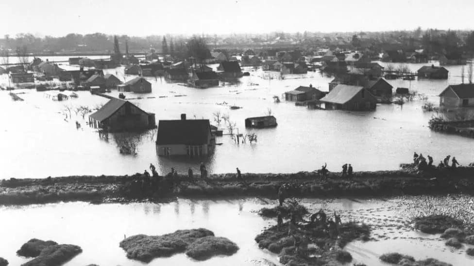
That profile is an argument about design, not sentiment. Rapid onset at night, in single-storey accommodation, occupied by people who cannot self-evacuate, is the exact combination that national policy now handles through vulnerability classification, safe access and escape, and a place of safety above the design flood level. The Environment Agency's standing advice asks for a route of escape set above estimated flood levels, and for evidence that a site could be evacuated before an extreme flood. The 2010 Xynthia flooding in western France killed 47 people in almost identical circumstances, and 32 of the 41 who drowned there were in bungalows. The lesson travels less well than it should.
The toll, place by place
The place-level figures have never been assembled in one table, which is part of why published totals disagree. These six communities account for 250 of the 307 deaths in England. The Lincolnshire figure is a county total that includes Mablethorpe and Sutton-on-Sea; the Norfolk figure runs the length of the coast from King's Lynn to Hunstanton and includes the 15 who died in King's Lynn itself.

| Place | Deaths | What the water did |
|---|---|---|
| King's Lynn to Hunstanton, Norfolk | 65 | Water 1.8 m deep in King's Lynn, and up to 8 km inland around Cley |
| Canvey Island, Essex | 58 | Sea walls collapsed after midnight; the whole island was evacuated |
| Lincolnshire coast | 43 | 22 major breaches from Mablethorpe to Skegness; 26 of the dead were over 70 |
| Felixstowe, Suffolk | 41 | The Orwell river wall gave way in seven places, into prefabricated homes |
| Jaywick, Essex | 35 | Water entered from the landward side, through a village of chalets |
| Harwich, Essex | 8 | The water broke over Stour Road and swept through the low-lying streets |
Lincolnshire County Council's own 70th anniversary account records the same 43 deaths and water reaching two miles inland.
Why no warning arrived
There was no national coastal flood warning service in Britain in 1953. The Met Office had issued gale warnings from Friday 30 January, but a gale warning is a warning to shipping and to the public about wind, not a statement that the sea is about to come over the wall at a named place at a named hour. Nothing existed to convert an observed water level in the north-east into an instruction to knock on doors in Essex.
The Waverley Committee found the reason, and it was institutional rather than technical. The Met Office held the weather information and the Hydrographic Department calculated the tides, and the two did not collaborate. Neither body had the other's half of the problem, so nobody held the whole of it. What warnings did exist were routed through police, river boards and the coastguard, on a Saturday night, in places where the telephone and telegraph lines had already been brought down by the wind. Over 200 lines went down in the north and north-east of Scotland alone. Amateur radio operators ended up providing communications for ten days.

Evacuation after the fact
The whole population of Canvey Island was eventually taken off, but the boats came after the water, not before it. That is the difference a warning chain makes: the same people, the same island, moved hours earlier and on foot.
Where a site cannot be made safe by level alone, the modern answer to that failure is a flood warning and evacuation plan that names who is warned, by what route they leave and where they shelter if leaving is not safe. That document exists because 1953 proved that defences without a warning chain are only half a system. Some gaps in that chain are still open: England has no property-level surface water warning service, and the Environment Agency's free warning service covers rivers, the sea and groundwater but not surface water. England also remains the only UK nation with no statutory duty on fire and rescue services to respond to flooding, so who actually comes to a flood is still a matter of local arrangement, and the Met Office does not issue flood warnings even now.
What the Waverley Committee recommended
The Departmental Committee on Coastal Flooding, chaired by Viscount Waverley, reported to Parliament on 3 June 1954 and did something no British body had done before. It set a standard of protection.
The maximum standard of protection… should be that sufficient to withstand the floods of January, 1953.
Departmental Committee on Coastal Flooding, reported to Parliament, 3 June 1954
The committee applied that standard where agricultural or property value justified it, which is a benefit-cost test in everything but name. Alongside it, Waverley recommended a coordinating authority for the various tidal Thames bodies, invited those authorities to investigate "the possibility and cost of erecting a structure across the Thames which could be closed in a surge", asked for research through two new advisory committees, and proposed lifting the ceiling on what river boards could precept from 4d to 6d in the pound. The committee had already dealt with warning in an interim report, which established an east coast flood warning system before the final report was written, which is a fair measure of how urgent that gap looked from the inside.
What 1953 built
Every institution that warns England about coastal flooding today traces back to the 1953 North Sea flood and the report that followed it, and the line of descent is unbroken.
- 1953: an east coast flood warning system. Set up on the committee's interim report, before it had finished its work.
- 1954: a standard of protection. Waverley's report, plus the Thames coordination recommendation and the invitation to investigate a closable structure across the river.
- The Storm Tide Warning Service. The first national organisation for coastal surge warnings, created to get forecasts to authorities and the public rather than only to shipping.
- 1996: the Environment Agency takes over. Public flood warning moves to a single body with a duty to issue it.
- 2009: the Flood Forecasting Centre opens. A joint Met Office and Environment Agency unit, created on the Pitt Review's recommendation, forecasting all sources of flooding in one place.
Defences were raised by up to 2 m and strengthened around population centres, in what became Britain's largest sea defence improvement programme. Waverley's invitation to investigate a closable structure across the Thames eventually produced London's tidal barrier. And a coastal frontage is now managed under a shoreline management plan that states, epoch by epoch, whether the intention is to hold the line, realign or stop intervening. The lineage reaches the present day: the Environment Agency's National Flood and Coastal Erosion Risk Management Strategy for England sets out a vision of "a nation ready for, and resilient to, flooding and coastal change – today, tomorrow and to the year 2100", which is Waverley's argument at a longer horizon.
Why 1947 produced nothing and 1953 produced everything
Britain had a worse river flood six years earlier and legislated almost nothing. The March 1947 snowmelt floods were the largest inland flood event of the century and produced no standard of protection, no warning service and no lasting institution. Coastal flooding in 1953 produced all three within eighteen months. The difference was not scale but speed and visibility: 307 people died in a single night, in the dark, in places reachable by a Sunday newspaper, and the failure was legible as a failure of the state rather than of the weather. The 1947 floods are covered separately, as are the floods of 1968 that followed.
Could a flood like 1953 happen again?
The event itself was not extraordinarily rare. At Lowestoft, the 1953 level is estimated to be roughly a 1-in-50-year event, and rising sea levels will shorten that return period. December 2013 produced a near-identical synoptic pattern, a low of 967 hPa against 1953's 964 hPa, and exceeded the 1953 water level at northern gauges: North Shields recorded 3.97 m above Ordnance Datum Newlyn against 1953's 3.56 m.
In December 2013 the Environment Agency issued 64 severe flood warnings, sent over 160,000 messages direct to homes and businesses and evacuated 18,000 people. Around 1,400 properties flooded. Nobody died in the coastal flooding.
That is what nine hours of warning is worth when there is a route for it. It is not an argument for complacency. Flood zones behind defences are drawn as though the defences were not there, for good reason; a defence in poor condition offers less than its design standard; and sea level rise is now assessed well beyond 2100, with climate change allowances applied over a development's lifetime. National guidance is explicit that an assessment must cover the residual risk from "the breach or overtopping of any flood defences", and the planning practice guidance notes that overtopping and breach produce different floods and have to be considered separately. What has changed since 1953 is that the observation now reaches the people standing behind the wall: the Environment Agency reported 1.6 million people signed up for flood warnings at the 70th anniversary, and every gauge, alert and warning in England is now published live on Check for flooding in England.
What 1953 left on the ground
The 1953 North Sea flood is still legible at street level, and that matters practically as well as historically. Communities along the east coast fixed plaques and cut marks at the level the water reached, and those marks are a site-specific record of a real flood level at a real address, which is something no national dataset holds at that resolution.
For an assessment, these marks sit alongside the formal record rather than replacing it. Recorded flood outlines come from the Environment Agency under a Product 4 data request, local archives hold the street-level detail, and a surviving high water mark can confirm or contradict both. Anyone wanting a first look at what is recorded for a particular address can check flood risk by postcode before commissioning anything.
If you are assessing a site on a defended coast or estuary, the questions the 1953 North Sea flood raised are still the ones an assessment has to answer: what happens when the defence is overtopped rather than merely reached, how deep and how fast the water is behind it, and how the occupants are warned and where they go. Unda prepares flood risk assessments for coastal and estuary sites across England and Wales, including breach and overtopping assessment and the warning and evacuation documents that discharge planning conditions. Call 01293 214444 or email enquiries@unda.co.uk.
Frequently asked questions
How long did the North Sea flood of 1953 last?
The flooding in England arrived on a single tide overnight on 31 January and 1 February, but the water stayed for far longer. Around 90% of the breaches in England were closed within a month, with 30,000 emergency workers involved at the peak of the operation on 12 February 1953. It took roughly nine months to drain all the water and repair every breach in the sea walls.
How many died in the 1953 floods?
Published totals differ because they count different things. In England 307 people died on land. Nineteen died in eastern Scotland, and the UK toll at sea was around 224, including more than 130 of the 179 people aboard the ferry MV Princess Victoria. The Netherlands lost 1,836 and Belgium 28. Adding land and sea tolls across all four countries gives roughly 2,400. That is why some sources say "more than 2,000" and others quote a single national figure without saying which.
How high did the water reach, and how is that measured?
Three different quantities get quoted interchangeably, which is why the published figures look contradictory. The water reached about 5.6 m above mean sea level at the worst-affected southern locations, which is a total still-water level. The residual, meaning the amount by which the sea exceeded the predicted tide, peaked at around 2.74 m at Southend and 2.97 m at King's Lynn. A gauge reading such as North Shields at 3.56 m is a total level against a stated datum, Ordnance Datum Newlyn. A figure without its datum and its type is not usable.
What was the worst storm in the North Sea?
For loss of life, 1953 is unmatched in the modern record. It remains the highest recorded sea level for many sections of the English east coast, and was over half a metre above anything recorded in the previous 80 years. December 2013 was arguably the more severe event meteorologically and produced higher water at northern gauges, but killed nobody through coastal flooding.
Does the 1953 event still set the standard for coastal defences?
Not directly. Waverley's "sufficient to withstand the floods of January, 1953" was superseded by probability-based design. Defences are now specified against an annual exceedance probability, with an allowance for sea level rise over the development's lifetime, rather than against a single historical event. What survived is the principle Waverley established: that a defence is designed to a stated standard, and that the risk remaining above that standard has to be assessed rather than assumed away, as the Environment Agency's standing advice requires.
Where can I find out whether a site flooded in 1953?
Recorded flood outlines are held by the Environment Agency and supplied under a Product 4 data request, which includes recorded flood extents and, where held, breach hazard information. The Agency has 20 working days to respond. Local archives are often better for street-level detail: the Essex Record Office holds the county's records of the disaster, including Hilda Grieve's The Great Tide, the official Essex account published in 1959.
About the author. Edward is a co-founder and Director of Unda with 20+ years in flood risk and drainage, and a national-press commentator on flooding. Unda has been trading since 2014, is a CIWEM Business Partner with CIWEM member and chartered (C.WEM MCIWEM) consultants, and has delivered 5,000+ flood risk assessments and drainage strategies across England and Wales.
Edward Bouët · BSc (Hons)


One of our experienced Flood Risk Consultants will get back to you within 60 minutes
