Dry Island Sites: The Flood Risk Problem Outside the Flood Zones
Estimated reading time 13 minutes
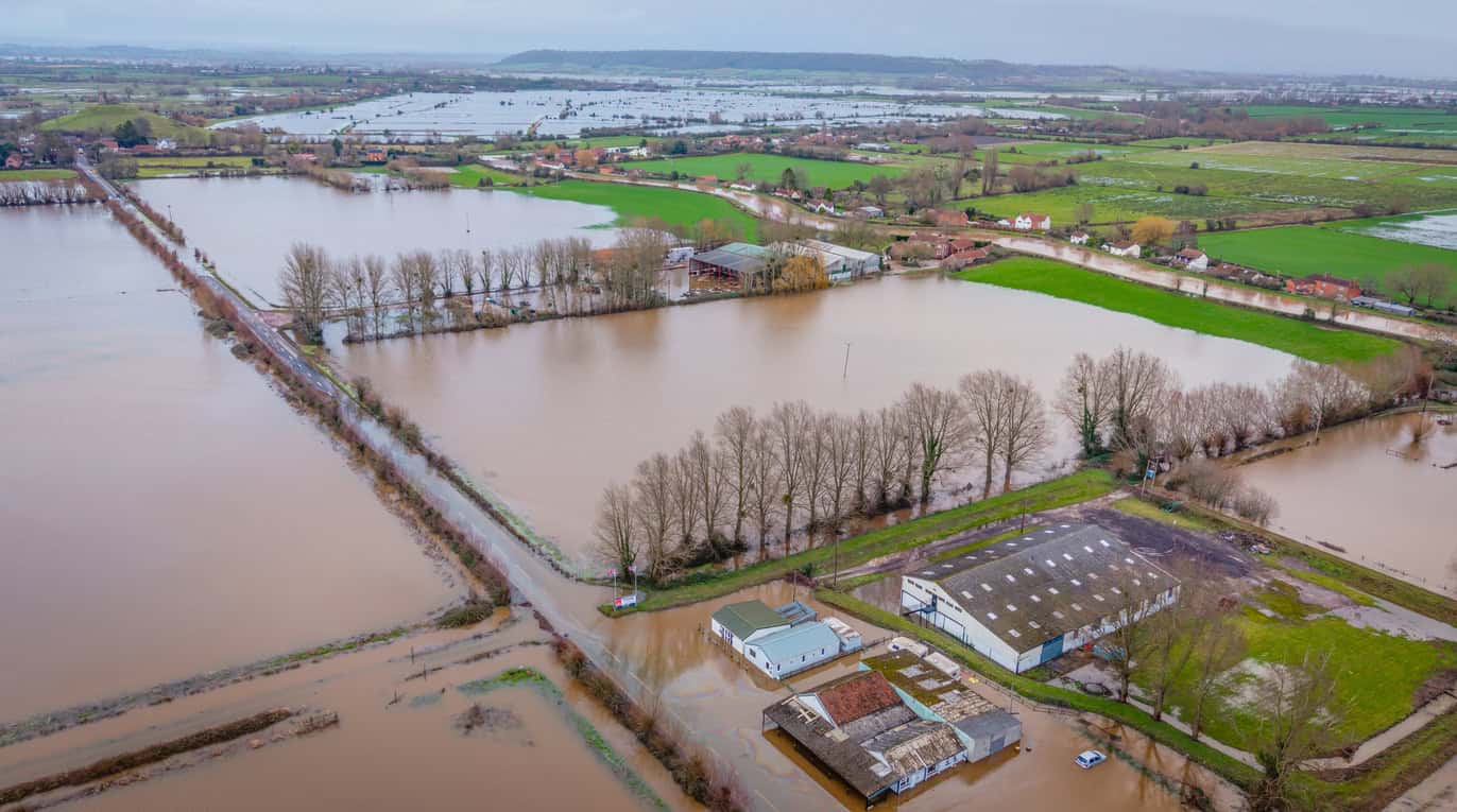
A dry island is a piece of land that does not flood, surrounded by land that does. The site stays dry; everything around it goes under. Dry island flood risk is what follows from that position: occupants cannot leave, emergency vehicles cannot reach them, and the services the site depends on can fail, all while the flood maps show the site itself sitting in Flood Zone 1.
Several English councils treat dry islands as flood risk areas for exactly that reason, setting out in their strategic flood risk assessments and, in a few cases, in adopted local plan policy what an applicant on one is expected to demonstrate. National planning policy does not name them at all.
In February 2025 the Planning Inspectorate dismissed a scheme for 19 flats at Chertsey on this basis. The site was in Flood Zone 1 and would not itself have flooded.
Is your site outside the flood zones, but surrounded?
Unda assesses access, egress and isolation on dry island sites across England and Wales.
Get a flood risk assessment quoteWhat a dry island is, and how one forms
A dry island forms wherever a patch of higher ground sits inside a floodplain. The ground is high enough to stay clear of the design flood, but the land between it and the rest of the settlement is not. When the river rises the higher ground is still dry, and now separated from everywhere else by water deep enough to stop a car and fast enough to take a person off their feet.
Four consequences follow from that separation, and they are worth keeping apart from one another, because an assessment written in a hurry tends to address the first and quietly forget the remaining three.
- Egress. Occupants cannot leave, however dry their own building remains. The people who most need to go, among them the elderly, the infirm, young children and anyone with limited mobility, are the least able to use a marginal route.
- Emergency access. Fire, ambulance and police vehicles cannot reach the site, or can reach it only at increased risk to their crews. A fire or a medical emergency on the island during the flood becomes a far harder thing to answer.
- Loss of services. Electricity, water, foul drainage and telecommunications can fail, and routine access to healthcare, schools and shops is cut even where the building itself is untouched. Where a development depends on continuity of service, that is the consequence to quantify.
- Duration. Fluvial flooding on the larger rivers lasts days rather than hours, which turns an emergency into a welfare and supply problem.
The first two are the ones most often assessed. The third and fourth are the ones an Inspector at Chertsey singled out as the reason dry islands count as flood risk areas at all: properties on one may lose key services and be surrounded by deep floodwater, even though they never flood. Anyone commissioning a flood risk assessment for planning on such a site should expect all four to be addressed.
The councils that name the problem, and the national policy that does not
"Dry island" is a local term. It appears in strategic flood risk assessments, in a handful of adopted local plans and in appeal decisions, and nowhere in the National Planning Policy Framework, the Planning Practice Guidance or the Environment Agency's standing advice. There is no national definition, no national threshold, and no national method for identifying one.
| Authority | Definition used | Where it sits |
|---|---|---|
| Hart District Council | "areas that don't flood directly from rivers, but may be cut off from other parts of Hart during a flood event" | Published dry island lists, maps and standalone access and egress guidance |
| Runnymede Borough Council | "areas of land either in flood zone 1 or 2 that are surrounded by land at a higher risk of flooding" | SFRA mapping, plus Local Plan Policy EE13 |
| Kingston upon Thames | "areas within Flood Zone 1 that are surrounded by areas at higher risk of flooding, i.e., areas falling within Flood Zone 2 and 3" | SFRA policy recommendation |
| Broads Authority | "areas of a lower flood risk surrounded by areas of higher flood risk, such as flood zone 1 surrounded by flood zone 3" | Policy PODM7 and a flood response plan requirement |
Where a council has adopted a dry island policy, that policy sets the test. Runnymede's Policy EE13 expects an applicant on a dry island to address the onset and duration of a flood, the vulnerability and willingness of occupiers to evacuate, and whether the site can operate an effective evacuation procedure. Hart publishes dry island lists, maps and its own access and egress guidance. Kingston and the west London boroughs carry the requirement as an SFRA recommendation; the Broads Authority handles it through Policy PODM7 and a flood response plan.
National policy reaches the same destination by a different route. The August 2026 NPPF gathers flood risk into a new Chapter 18, where Policy F7 requires development to be safe across its lifetime and to provide safe access and escape, and Framework compliance is judged on that basis. It never mentions islands; it does not need to.
National guidance is further behind than it looks. The Planning Practice Guidance on flood risk was last updated on 17 September 2025 and still cross-refers to paragraph numbers the August 2026 Framework replaced.
Where dry islands are found, and where they are named
Dry islands are not a regional phenomenon. Any floodplain with undulating ground inside it will produce them, which puts them on rivers of every size across the whole of England. They range from a single house on a slight rise, through a farmstead and its yard, to several hundred hectares carrying a school, a parade of shops and a few hundred homes.
What makes the lower Thames the standard example is planning history rather than geography. The islands along that reach are large, sharply defined and densely built on, and the authorities there have done something about them: Runnymede's SFRA maps them across the east of the borough, with the largest at Egham Hythe and in Chertsey itself, and the same landscape produces them at Datchet, Wraysbury and Shepperton. Hart District Council has done the same in the Blackwater valley, around Darby Green, Frogmore, Blackwater, Eversley, Yateley, Hook and Fleet. The Broads has its own, formed by a different mechanism but posing the same problem.
Most authorities have done neither, which is why so few sites are ever identified as sitting on one. A council's silence is not evidence, and neither is an old map: Runnymede mapped islands larger than 0.5 hectares using its 1 in 100 plus 20% models, an allowance the climate change guidance has since moved past, and the Hart maps carry a 2010 date with the list behind them running from 2010 to 2012. An island drawn against a superseded allowance may be larger, smaller or a different shape under the allowance that applies now.
A site can sit on a dry island in a district that has never mapped one, never written a policy on them, and does not use the term at all.
Chertsey: Flood Zone 1, and still refused
The Chertsey decision is the clearest worked example. The proposal was a prior approval under Class MA to convert a commercial building at Abbey Green into 19 flats, on a site that sat in Flood Zone 1, on a dry island entirely ringed by Flood Zone 2 with Flood Zone 3 in the wider area beyond it. On the face of the flood maps, it was about as low risk as a site in Chertsey gets.
What defeated it was the route out. An escape route along Guildford Street had been accepted in earlier decisions, but updated Environment Agency hazard data showed it was no longer safe in a 1 in 100 year plus climate change event. The alternative ran roughly 140 metres along the A320, a 50mph dual carriageway with no footway, and required evacuees to cross the road at several precise points to stay inside the low hazard corridor. The Inspector found it convoluted and impractical, and noted that a slight deviation would put someone into water carrying a higher hazard rating.
The dry island already contains residential uses, but this does not justify introducing further residents who would also be placed at risk during a flood event, or the placing of greater pressure on emergency services. Similarly, although the appeal site may remain free of flooding … this does not absolve the need for a safe evacuation route.
Appeal decision APP/Q3630/W/24/3349839 · 25 February 2025
Flood warning did not save it either. The Thames gives days of notice, and the Inspector still considered it unlikely that occupants would leave their homes that early.
Shepperton: above the flood level, and still stranded
The point is not confined to sites anyone has labelled. At 1A Priory Stables in Shepperton, an appeal for six static mobile homes was dismissed in January 2026 on the same logic. The homes stood at about 13.00m AOD, above both the design flood level of 12.38m AOD and the 0.1% event at 12.39m AOD. They would not have flooded.
Chertsey Road, the only way in and out, would have. Environment Agency hazard mapping rated it "danger for most", meaning most people would struggle to stand or escape safely, and the Inspector held that conditions requiring the caravans to be raised and tethered did not answer the concern that people could be left stranded on the site with no safe means of escape.
Neither appeal turned on whether the buildings would flood. Both turned on whether anyone could leave.
How to check whether your site is on a dry island
The check looks outward rather than down. Because a dry island is defined by the land around a site rather than the ground beneath it, the site's own flood zone answers almost nothing, and a desk study that stops at the red line will miss the condition entirely.
- Look at the surroundings, not the site. Establish the flood extent across the whole area the site sits within, using current Environment Agency depth and hazard data together with the climate change allowance that applies now, rather than the red line alone. The Flood Map for Planning is the starting point, not the answer.
- Trace every route off, to its end. A route counts only if it reaches land wholly outside the design flood extent, and only if people can use it without help. One that stops on higher ground still inside the flooded area is not an escape route.
- Read the local evidence base. Check whether the council's strategic flood risk assessment maps dry islands and whether the local plan carries a policy on them, and note the date and the climate change allowance behind that mapping.
- Re-check anything previously accepted. A route agreed on an earlier application can stop being safe when the modelling is reissued, which is precisely what happened to the Guildford Street route at Chertsey.
What it changes for a planning application
Being on a dry island does not make a site undevelopable. It moves the argument. The site will normally be in Flood Zone 1, so on a literal reading of the Sequential Test it is sequentially preferable to almost anywhere nearby, and the council will still treat it as a flood risk area. The case has to be made on access and egress, on the duration of isolation, and on what happens to the services the development depends on.
That means building the evidence deliberately: an assessment that maps the island and tests the routes off it, a flood warning and evacuation plan that does not rest on warning lead time alone, and an honest account of how long the site could be cut off. Where the wider planning balance is in play, the Yatton decision is a reminder that flood risk findings are weighed rather than applied mechanically.
Unda prepares flood risk assessments and evacuation planning for dry island sites across England and Wales, including the lower Thames boroughs where the policy on them is most developed. If a site is in Flood Zone 1 but ringed by Zone 2 or 3, the access case is worth settling before the application goes in rather than after the objection arrives. Call 01293 214 444 or email info@unda.co.uk.
Frequently asked questions
Is a dry island the same as an island in a river?
No. A river island is land permanently surrounded by water and shown as such on a map. A dry island is dry land that only becomes an island during a flood, and it appears on no map as an island at all, which is why it is so easily missed at desk study stage.
Does a site on a dry island need a flood risk assessment?
Often, though not because of the dry island itself. Under the August 2026 NPPF a site in Flood Zone 1 triggers an assessment where it is one hectare or more, sits in a critical drainage area, or is shown at risk from another source. Where a council has a dry island policy, it will expect the access and egress case whether or not an assessment is otherwise triggered.
Does the dry island problem apply in Wales?
The term is English, but the problem is not. TAN15 requires a flood consequences assessment to address emergency access and the consequences of flooding for people, which covers a site cut off by water it never takes on.
What if the council has no dry island policy?
The condition still applies and should still be assessed. Most English councils have no policy naming dry islands, and the Shepperton appeal shows a scheme refused on isolation grounds in a district that does not use the term.
About the author. Jackie is a co-founder and Director of Unda with 30+ years in flood risk, and sits on CIWEM's South Eastern Branch committee. Unda has been trading since 2014, is a CIWEM Business Partner with CIWEM member and chartered (C.WEM MCIWEM) consultants, and has delivered 5,000+ flood risk assessments and drainage strategies across England and Wales.
Jackie Stone · MSci, BSc (Hons), DIC, CIWEM Environmental Partner
Latest news






One of our experienced Flood Risk Consultants will get back to you within 60 minutes
