Bridgwater Tidal Barrier: How It Works, What It Costs and When It Opens
Estimated reading time 13 minutes
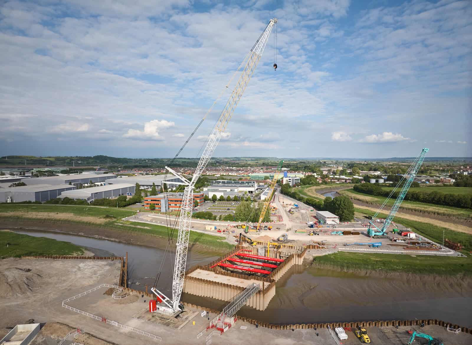
The Bridgwater Tidal Barrier is a flood barrier being built across the River Parrett near Express Park in Bridgwater, Somerset, by the Environment Agency and Somerset Council. When an exceptional tide is forecast, two 15-metre vertical lift gates will close the river, and new and raised banks downstream will stop the surge going round the ends. The scheme is designed to protect about 11,300 homes and 1,500 businesses to a 1-in-200-year tidal standard until 2125.
It is not finished. As of October 2026 the foundations are going in, most of the downstream banks are built and the towers are due to start rising in 2027, while the cost remains pinned to a £249 million baseline set in 2024 and no operating date has been announced. For anyone planning development in the town, the practical point comes first: the barrier does not take Bridgwater out of the floodplain, so most sites near the Parrett will still need a flood risk assessment for planning that deals with the risk the barrier leaves behind.
Somerset Council's update of 14 October 2026 says the project team expects to be on site for another five years, with an operational timeline to follow once the cost work is finished.
What is the Bridgwater Tidal Barrier?
The Bridgwater Tidal Barrier Scheme is a set of works along the lower Parrett, not a single structure. The barrier spans the river opposite Chilton Trinity, north of the town centre. Banks and walls at Chilton Trinity, Pawlett and Combwich complete the defence line downstream, and fish and eel passes upstream offset the effect a closed barrier has on migrating species.
Its legal basis is the Bridgwater Tidal Barrier Order 2022, a Transport and Works Act Order with deemed planning permission, which authorises the barrier, a 30-metre waterway opening split across the two gates, scour protection and the associated works.
| Element | Location | What it does |
|---|---|---|
| Barrier | Across the Parrett beside Express Park, opposite Chilton Trinity | Closes against exceptional incoming tides |
| Operating site | Express Park | Houses the control and operating facilities |
| Downstream defences | Chilton Trinity, Pawlett and Combwich | New and raised banks, walls and seepage cut-offs |
| Fish and eel passes | Upstream Parrett system and the River Tone | Up to 12 passage sites to offset effects on migratory fish and eels |
England already has tidal barriers at Ipswich and Hull, and the best known is the Thames Barrier. The explainer on types of flood defence sets out how barriers compare with walls, embankments and flood storage.
Why does Bridgwater need a tidal barrier?
Bridgwater sits on the tidal Parrett, upstream of Bridgwater Bay and the Severn Estuary, and the Bristol Channel has one of the largest tidal ranges in the world. A storm surge riding a high spring tide can push water a long way up the river and into the town. The Parrett can also become tide-locked. At high tide it cannot drain to the sea, so river water backs up behind the tide.
The existing walls have been tested, and not always comfortably. The government's 2022 accounting officer assessment records a river wall collapse in 2011 and a further near miss in 2020, and it set the barrier against 19 long-listed options. Raising the town's walls instead would have meant rebuilding bridges and changing the riverside townscape, and every extra course of wall makes it harder to drain the land behind it.
In 2014 the Parrett came within 0.15 metres of flooding Bridgwater, according to the government's own appraisal of the scheme.
The scheme deals with tidal flooding and nothing else. Rainfall flooding on the Somerset Levels and Moors, surface water in the town's streets and groundwater in the alluvium all need other measures. For the tidal hazard itself, see what tidal flooding is and how it is mapped; the River Parrett flood risk page follows the river from source to estuary.
How does the Bridgwater Tidal Barrier work?
For most of the year the two gates sit raised clear of the water and the river flows as normal. When a tide is forecast to exceed a pre-agreed level in Bridgwater, operators lower the gates at low water, hold them shut through the peak for about four to six hours, and reopen them once levels downstream have fallen. Closing early matters. It leaves room in the channel upstream for river water to collect while the tide is held out.
- Forecast. The tide and surge forecast, and the flow coming down the Parrett, are checked against the closure trigger.
- Close at low water. The gates come down before the tide rises, keeping the upstream channel as empty as possible.
- Hold through the peak. The barrier excludes the high estuary level while river water keeps arriving from upstream.
- Reopen gradually. Once the downstream level has dropped far enough, the gates lift and the river discharges again.
Somerset Council expects up to five flood closures a year at first, rising with sea level to perhaps 55 a year by 2126, plus maintenance and training closures up to twice a month. It says operating the barrier will not increase river flood risk to lives and homes along the Parrett.
A closed river is only half a defence. Surge water would otherwise spread round the ends of the barrier across the low ground downstream, which is what the banks at Chilton Trinity, Pawlett and Combwich are there to stop. The Somerset Rivers Authority reports 4.3 kilometres of new banks and 2.8 kilometres of raised banks, with sheet-pile cut-off walls beneath them to limit water seeping through the ground.
The standard of protection is the 1-in-200-year tide, a 0.5% annual exceedance probability. That is not a flood every 200 years. Over 30 years, a 0.5% annual chance adds up to roughly a 14% chance of at least one such tide, and the flood return period calculator shows the arithmetic. Bridgwater's protection runs to 2125, although some downstream banks will need raising around 2055.
What changed in the 2026 redesign?
In January 2026 the Environment Agency announced a more efficient design. The two gates stay, and so does the flood protection outcome; what changed is how the structure above them is built and maintained.
- Lower towers. The towers lose about 10 metres in height, finishing at around 15 metres tall and 6.3 metres wide.
- Machinery at the base. The gate drive equipment moves from the top of each tower to its base, where maintenance teams can reach it.
- Simpler shapes. The tower forms are more uniform and the mechanical layout has been updated.
- Lighter walkways. High-level operational walkways replace the overbridge in the earlier design. They are separate from the public foot and cycle bridge planned upstream of the barrier.
No new planning application is needed, according to the council:
These approvals allow flexibility for changes like this without needing a new planning application.
Somerset Council, Bridgwater Tidal Barrier design efficiency review, October 2026
The September 2026 project newsletter adds that the towers will be precast off site and assembled locally, and that fabrication of the gates has started.
How much does the Bridgwater Tidal Barrier cost?
The approved cost is £249 million, the baseline set in the 2024 business case. It is not the final figure. The council's October 2026 update says a revised forecast will be shared, and it presents the redesign as a way of containing cost pressure, not as a saving against the baseline. Several other figures are in circulation, and adding them together gives a wrong answer.
| Figure | Source and date | What it represents |
|---|---|---|
| £100m | Defra, March 2022 | Early estimate, superseded |
| £249m | 2024 business case | Approved baseline, not a final cost |
| £43m | Government, February 2025 | One year's funding announcement |
| £59.3m | Government, March 2026 | Indicative allocation for 2026/27 |
| £101m | Kier, June 2026 | A single construction contract |
| £91m | Environment Agency | Partnership funding within the total |
| Up to £13.7m | Somerset Council, August 2024 | The council's committed contribution |
Partnership funding comes from council developer contributions, Town Deal money and the Somerset Rivers Authority, among others. The Environment Agency's Flood and Coastal Erosion Risk Management Grant-in-Aid covers the rest. The £59.3 million for 2026/27 came out of the £1.4 billion programme for that year.
At £59.3 million, the barrier received the largest single 2026/27 allocation in England's £1.4 billion flood defence programme.
How a single year's allocation sits inside the decade-long totals is covered in the explainers on the £7.9bn flood defence programme and 2026/27 flood defence funding.
When will the Bridgwater Tidal Barrier be finished?
No date has been set. The council expects the main downstream construction to finish by the end of 2026 and work on the superstructure, the towers and gates, to begin in early 2027; the September newsletter narrows that to spring. After that the team expects another five years on site, landscaping included. Older statements that the barrier would be operating in 2027 are out of date.
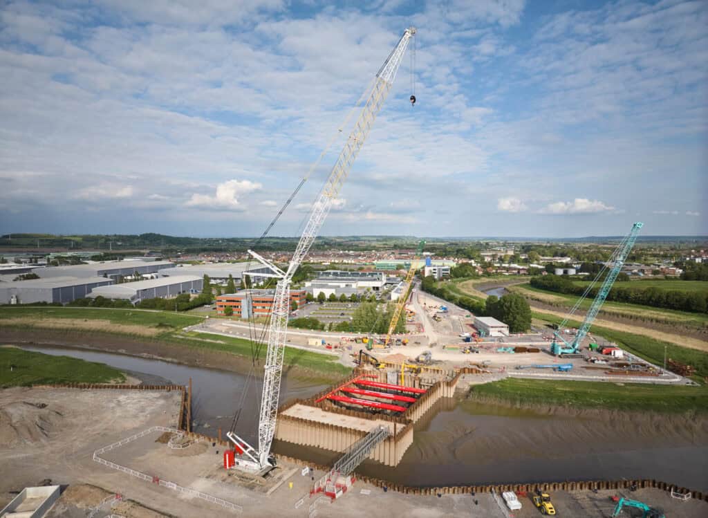
Construction has come a long way since the enabling works and test piling of 2023. A jack-up barge arrived in March 2025 to build the cofferdams, and in June 2026 Kier announced a £101 million construction continuation contract to complete the substructure. The council's October 2026 account reports progress at each location:
- Barrier site. Marine operations are complete and work has moved on to the foundations, with reinforcement under way beneath the central pier.
- Chilton Trinity. The new secondary embankment now joins the seepage cut-off wall, giving a continuous flood bank through the village.
- Pawlett. The secondary embankment is complete, the primary embankment is being widened and a new steel flood wall stands at the end of River Road.
- Combwich. The primary embankment is complete, permanent culverts are in place and landscaping is starting.
"Finished" can mean four different things: civil construction complete, the barrier commissioned and accepted for operation, the whole defence line working together, or the programme closed out with landscaping and habitat work done. A date for one is not a date for the others. Banks that are already built do not mean the barrier's protection is available yet.
What does the barrier mean for development in Bridgwater?
The barrier lowers the chance of a tidal flood in Bridgwater, but it does not change how the planning system treats the town. The Environment Agency's Flood Map for Planning draws flood zones as if defences did not exist. That is deliberate. It keeps in view what would happen if a defence failed, so the barrier will not redraw the zones and every planning policy that applies in them keeps applying.
A site protected by the barrier will still be shown in Flood Zone 3, and the Sequential Test still applies to it.
For an application, that has four consequences:
- The Sequential Test still applies. A new home in Flood Zone 3 still has to show there are no reasonably available sites at lower risk, and failing the test is normally grounds for refusal however good the defences behind the site. The sequential and exception test reports service covers this; the Sequential and Exception Tests explainer sets out the policy.
- Residual risk has to be assessed. An assessment must test what happens if the gates fail to close, a bank is breached or a tide overtops the defences. A report that leans on the barrier without testing those scenarios invites an Environment Agency objection. See residual flood risk for how it is assessed.
- Today's defences are the ones that count. Until the barrier is commissioned, an assessment has to reflect the protection that actually exists, not the finished scheme.
- Climate change still applies. Floor levels and safe access must allow for climate change over the development's lifetime, which for housing is usually 100 years.
The explainer on why a site stays in a flood zone after new defences covers how defended areas are mapped. Local requirements, including Somerset Council's role as Lead Local Flood Authority, are set out under flood risk assessment in Bridgwater and the Somerset Council flood risk and drainage requirements.
Unda's consultants prepare a flood risk assessment for planning on sites along the tidal Parrett, testing breach and overtopping scenarios against proposed floor levels. Call 01293 214444 or email enquiries@unda.co.uk to discuss a Bridgwater site.
Bridgwater Tidal Barrier: frequently asked questions
Who is building the Bridgwater Tidal Barrier?
The Environment Agency leads the scheme, with Somerset Council as delivery partner. Kier is the main contractor and AtkinsRéalis the design partner, while Red7Marine did specialist marine piling for Kier. The Somerset Rivers Authority helped fund early development, and Oxford Archaeology led the archaeological investigation.
Will the barrier stop the Somerset Levels flooding?
No. It keeps exceptional tides out of Bridgwater and the lower Parrett. The long floods on the Levels and Moors, as in 2013–14 and January 2026, come mainly from rainfall on a slow-draining, pumped landscape, which a tidal barrier does nothing to relieve. The Somerset Levels flooding explainer covers what does.
What happens to fish and eels when the barrier closes?
The Order authorises up to 12 passage improvements: seven for eels in the Parrett system and five for fish and eels on the Tone, including Firepool and French Weir in Taunton. An Environment Agency update in May 2026 scheduled the work for two years from 2027, opening more than 80 kilometres of watercourse.
Has anything been found during the excavations?
Oxford Archaeology's evaluation dug 241 trenches and 54 geotechnical pits. It found evidence that may relate to Iron Age and Roman settlement and to the medieval settlement of Pignes, though some features are only provisionally dated.
Will there be a new crossing over the Parrett?
A separate pedestrian and cycle bridge is planned upstream of the barrier; the walkways on the barrier itself are for operational access only. A riverside park has also been proposed, but the council has said it depends on additional funding.
About the author. Antony is a Senior Flood Risk and Drainage Consultant leading Unda's drainage and SuDS team. Unda has been trading since 2014, is a CIWEM Business Partner with CIWEM member and chartered (C.WEM MCIWEM) consultants, and has delivered 5,000+ flood risk assessments and drainage strategies across England and Wales.
Antony Rousou · BSc (Hons), C.WEM MCIWEM


One of our experienced Flood Risk Consultants will get back to you within 60 minutes
