Monmouth Flooding: What the Storm Claudia Investigation Found About the Town’s Defences
Estimated reading time 14 minutes
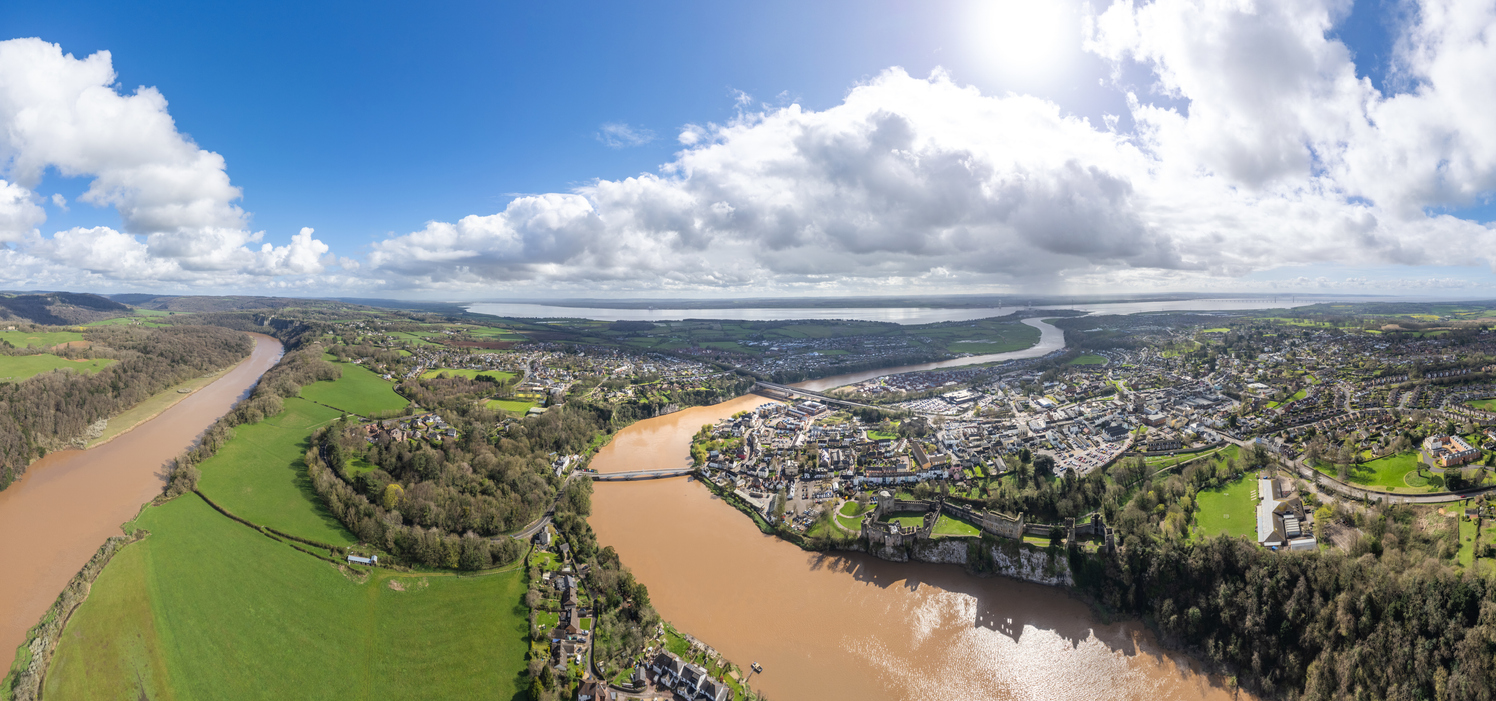
Monmouth flooding during Storm Claudia took the River Monnow to the highest level on record in the town. On the night of 14 to 15 November 2025 the river overtopped the town's 1991 flood defences upstream of Monnow Bridge, and around 351 homes and businesses in the town flooded internally. The statutory investigation published by Monmouthshire County Council in autumn 2026 finds that the defences did not breach. They were overtopped by a flood that, on the investigators' estimate, should have been within their stated standard. That gap now puts the defences, and the planning map that relies on them, under review.
NRW rates Monmouth's defences at a 1 in 100 year standard. The flow that overtopped them was estimated at around 1 in 50 to 1 in 75 years.
What happened in Monmouth during Storm Claudia?
Storm Claudia brought several days of rain to Monmouthshire between 9 and 15 November 2025, with the worst of it falling on 14 and 15 November onto ground that was already saturated. The Monnow rose fast. It reached the highest level on record at the Monnow Gate gauge in Monmouth, 6.66 metres above Ordnance Datum at 02:45 on 15 November, and spilled over the town's defences for their length between Monnow Bridge and Castle Hill. South Wales Fire and Rescue Service declared a major incident, and NRW issued four Severe Flood Warnings over two days.
The findings come from the River Monnow Catchment Section 19 Flood Investigation Report, prepared by JBA Consulting for the council as lead local flood authority. A Section 19 investigation, named after section 19 of the Flood and Water Management Act 2010, records what flooded, why, and what each authority did. Wales's national flood strategy expects one wherever more than 20 homes are affected. It does not assign liability, and its recommendations are advisory. Across the four areas studied it counts about 403 properties affected.
- East of the Monnow. 129 properties flooded internally, 88 of them commercial premises on Monnow Street and nearby.
- South of the Monnow. 121 properties flooded internally around Wonastow Road, with depths over 2 metres reported near Goldwire Lane.
- West of the Monnow. Flooding along Cinderhill Street and Drybridge Street, the caravan park, and the Wonastow Road pumping station, which failed once the river defences beside it overtopped.
- Upstream. Skenfrith, Rockfield and Forge Road in Osbaston, none of which has a defence built to the town's standard.
For anyone holding land or preparing a planning application in the town, the parts of the report that matter most concern the defences and the mapping. A flood consequence assessment for planning in Wales on a Monmouth site now has to account for a standard of protection that the council's own investigation calls uncertain.
How rare was the Monmouth flood?
It depends where the measurement is taken, and the report is careful to separate them. Rainfall over the Black Mountains, at the head of the Monnow, was very rare. Flow in the Monnow was rare but well within the range of events a 1 in 100 year defence is built for. The Wye, which reached its highest recorded level at Monmouth in February 2020, barely registered.
| Measure | Where | Estimated return period | Annual chance |
|---|---|---|---|
| Rainfall | Black Mountains (Vowchurch and Tafalog gauges) | About 1 in 150 to 1 in 200 years | About 0.5% to 0.6% |
| River flow | River Monnow at Grosmont, highest on record | About 1 in 50 to 1 in 75 years | About 1.3% to 2% |
| River flow | River Wye at Monmouth | About 1 in 2 to 1 in 5 years | About 20% to 50% |
The storm came from the east, which is unusual. Easterly systems stall over the Black Mountains and the upper Monnow, where the Tafalog gauge recorded 118.4 mm in 24 hours, while the more common westerly storms drop more rain over the Brecon Beacons catchments. That is why the Monnow flooded Monmouth while the River Wye rose only moderately. A 1 in 75 year flow has an annual exceedance probability of about 1.3% in every year, which is a long way from a promise of 75 quiet years, as the guide to flood return periods and annual probability explains.
Four of the highest floods on record at Monmouth have happened since 2019, including Storms Dennis, Bert and Claudia.
Why did the Monmouth flood defences overtop?
The Monmouth flood defences are mostly earth embankments with short lengths of raised wall, built in 1991 and maintained by Natural Resources Wales. NRW advises that they give a 1 in 100 year standard of protection, meaning they are designed to keep out a flood with a 1% chance of happening in any year, and defences built before 2016 do not need a climate change allowance to count towards a TAN15 Defended Zone. On the night, the river rose over them at low points along Monnow Keep first, then behind the shops near Monnow Bridge, and the water ran down Monnow Keep and Monnow Street towards Chippenham Fields.
The report is clear that this was overtopping, not a breach. No defence failed structurally. West of the Monnow the landward face of an embankment eroded as water poured over it, and NRW has since repaired it from its own capital budget. The Welsh Government's £1.8m emergency repair fund covered damaged council-owned defences in eleven areas, Monmouthshire among them. Some reporting of the flood has called it a breach. The distinction matters. A breach raises questions about a structure's condition. Overtopping in a flood the defence was meant to contain raises questions about the standard itself.
It is therefore considered likely that the Flood Map for Planning and the associated modelling informing this dataset may not fully reflect the current performance of the defences.
River Monnow Catchment Section 19 Flood Investigation Report, JBA Consulting for Monmouthshire County Council
The report suggests why. Design flows may have risen since 1991 through newer flood data, better estimation methods and changing conditions. NRW is building a new hydraulic model of Monmouth with updated hydrology and survey to review the standard the defences actually give. The report's recommendation M002 asks NRW to review that standard and to consider whether the flood zone mapping still reflects how the defences perform. The difference between a standard on paper and performance in a real flood is the subject of the article on below-standard flood defences.
When did the severe flood warning arrive in Monmouth?
After the water. Parts of Monmouth were under a Flood Warning throughout the event, but the Severe Flood Warning for Monmouth town was not issued until 03:31 on 15 November, about two hours and twenty minutes after the defences had overtopped. CCTV from a business near Monnow Keep shows water entering the building at about 01:00.
21:30 · Grosmont
The Monnow peaks at the upstream gauge, the highest flow on record there.
23:15 · Skenfrith
The river peaks at Skenfrith, about 16 km upstream of Monmouth.
About 01:00 · Monnow Keep
The defences overtop and water enters the first buildings.
01:15 to 01:55 · Monnow Street
Shops along the north-eastern end of the high street flood internally.
02:45 · Monnow Gate
Record river level of 6.66 m above Ordnance Datum in the town.
03:31 · Monmouth town
The Severe Flood Warning is issued, about 2 hours 20 minutes after the defences overtopped.
Two things help explain the gap. The Monnow Gate gauge rose sharply in the two hours before the defences overtopped, and the investigators could not establish the cause of that surge. The same gauge is also hard to read, because it sits where the Wye and the Monnow meet, so its level depends on which river is driving the flood. Recommendation M001 asks NRW to assess its location and look at alternative set-ups. The upstream gauges at Grosmont and Skenfrith gave the earlier signal, which anyone can follow on a live river levels map or on NRW's Rivers Wye and Monnow flood alert page.
The council's survey adds a second problem. Of 131 people who replied, 83 said they were signed up to NRW's flood warnings, and 40 of those said they received no alert or warning. Sign-up in Monmouth town was lower than in the villages, at 60 of 101 respondents, and the report warns that it could not tell when people registered, so the figures need care before anyone draws firm conclusions about how the service performed. Warning time decides whether temporary barriers go up and stock is moved, as the guide to temporary and demountable flood barriers sets out, and recommendation MC002 asks NRW to review the timing of severe warnings across the catchment.
What does the defences review mean for development in Monmouth?
A great deal, if the review finds the defences fall short. Large parts of central Monmouth, including most of Monnow Street and the land around Drybridge Street and Wonastow Road, are mapped as a TAN15 Defended Zone for rivers on NRW's Flood Map for Planning. Under Technical Advice Note 15, a Defended Zone is land behind defences that give at least a 1 in 100 year standard against river flooding. Without that label the same land would sit in Flood Zone 2 or 3.
The Welsh Government's TAN15 guidance says NRW reviews Defended Zones every two to three years from a May 2025 baseline. Where the standard of protection has dropped below the threshold, the Defended Zone is removed and the land is reclassified as Flood Zone 2 or 3. Monmouth town centre is the obvious candidate. NRW's new model will show whether its defences still reach 1 in 100 years.
If the Defended Zone goes, much of central Monmouth would be assessed as Flood Zone 2 or 3, and in Zone 3 TAN15 rules out most new housing.
| Type of proposal | In a TAN15 Defended Zone | In Flood Zone 3 |
|---|---|---|
| New homes on greenfield land | Not appropriate unless allocated in the development plan | Should not be permitted, whatever the flood consequence assessment concludes |
| Redevelopment of a brownfield site | Can be considered, but should not intensify use | Only if essential to the Development Plan Strategy, for example to regenerate the settlement |
| Homes on the ground floor | Assessed against the TAN15 acceptability criteria | Not acceptable for residential use in a redevelopment |
| Flood consequence assessment | Required, including the overtopping and breach case where relevant | Required, and the strongest justification is needed |
For a developer, that is the difference between a town-centre scheme that can be argued on its flood consequences and one that is refused in principle. A conversion with a ground-floor flat, a redevelopment that adds dwellings, or a greenfield edge site drawing on the Defended Zone could all lose their policy basis. A Defended Zone has never been a presumption in favour of development, and TAN15 already requires an assessment of what happens if defences are overtopped or breached. What changes is how much weight a scheme can place on the defences at all. In Flood Zone 3 the council would also have to notify Welsh Ministers before approving highly vulnerable development on undeveloped land, under the 2025 Notification Direction.
There is a shorter-term risk as well. NRW does not remove Defended Zones in its six-monthly map updates, so the published map will still show the zone while the review runs. A flood consequence assessment that relies on the 1 in 100 year figure without testing the Storm Claudia evidence may face questions from NRW or the planning authority. Buyers and lenders looking at a town-centre site face the same uncertainty, and a flood risk assessment for due diligence can test it before exchange. The articles on the 2025 TAN15 changes and on residual flood risk go further into how the assessment works.
Site in Monmouth's Defended Zone?
Experienced flood risk consultants can test the scheme against the Storm Claudia evidence and TAN15 before the review reports. Free quote within 60 minutes.
Get a quoteSkenfrith, Rockfield and Forge Road: the places with no defences
Upstream of the town, the investigation finds communities relying on property flood resilience that gave little protection in a flood this size. Their recommendations are about delivery more than review.
- Skenfrith. 25 properties flooded internally. The village has no formal defences and has flooded four times in six years. NRW has supplied barriers and pumps, plans a wider property flood resilience scheme for 2026/27, and is preparing a business case for a flood alleviation scheme that must deal with the Norton Brook as well as the Monnow.
- Rockfield. Six properties flooded, with internal depths of up to about 0.9 metres and more in places. The settlement has no NRW flood warning area of its own, so residents watch the Skenfrith gauge. The report asks NRW to consider a new gauge upstream.
- Forge Road, Osbaston. 16 of 19 properties reported significant internal flooding. The embankment near the weir gives about a 1 in 5 year standard. NRW plans property flood resilience for Forge Road and Osbaston Road, with installation programmed for summer 2027.
Skenfrith's scheme has been slow. NRW budgeted £104,000 for an early business case after the 2019 and 2020 floods, then paused the work in 2023 because of budget pressure. The Welsh Government's 2026 to 2027 flood programme now allocates £700,000 to NRW for Skenfrith at the business case stage, covering 23 properties. The allocation sits at the business case stage, not construction. NRW's place in the Welsh system is set out in the guide to Natural Resources Wales and flood risk, and the wider funding picture in Wales's £85m flood investment.
What happens next for Monmouth flooding?
The report makes 20 recommendations, ten of them for NRW and seven for the council. None can be enforced, so progress depends on funding and on the authorities following through. For Monmouth itself, four steps follow in order.
- NRW completes the new Monmouth model, using updated hydrology and survey data.
- NRW reviews the defences' standard of protection against that model, as recommendation M002 asks.
- NRW decides on the Defended Zone at its next periodic review, and reclassifies the land as Flood Zone 2 or 3 if the standard has fallen below 1 in 100 years.
- Options for improving the defences would then go through the Welsh Government's business case process before any money is committed to building.
Alongside that, the council, NRW, Network Rail and the Wye and Usk Foundation are working with upstream landowners through the Resilient Rivers Monnow project to store water in soils and slow its run-off. The report asks NRW to consider a catchment management plan that builds on it. Natural flood management can slow the rise of a flood, though it has limits in an event the size of Claudia, as the article on leaky dams and flood risk explains.
Developers in the town should assume the defences' standard stays in question until the review reports. Assessing a Monmouth site under TAN15 now, against the Storm Claudia levels and the overtopping case, produces a submission that is easier to defend than one written on the assumption that the map will not change.
Frequently asked questions
How can I check whether a site is in Monmouth's Defended Zone?
Open NRW's Flood Map for Planning and switch on the TAN15 Defended Zones layer. Check that the zone covers the right source of flooding, because a site defended against rivers but not against another source is assessed under the ordinary zone rules for that source. The Defended Zone dataset for Monmouth was last republished in May 2026.
Who is responsible for flood defences in Monmouth?
NRW manages and maintains the main river defences along the Monnow and the Wye and runs the flood warning service. Monmouthshire County Council, as lead local flood authority, is responsible for flooding from surface water and ordinary watercourses, and it runs the Wonastow Road pumping station it delivered in 2007.
Can the Section 19 report make NRW upgrade the defences?
No. A Section 19 investigation has no power to require works. Its recommendations are advisory, and any scheme to raise the defences would need a business case and Welsh Government funding like any other flood scheme in Wales.
Where can the full Storm Claudia investigation be read?
Monmouthshire County Council publishes it on its flood investigation reports page. The report runs to about 150 pages, with flood mechanism maps for each study area and a separate hydrology report in its appendices.
About the author. Edward is a co-founder and Director of Unda with 20+ years in flood risk and drainage, and a national-press commentator on flooding. Unda has been trading since 2014, is a CIWEM Business Partner with CIWEM member and chartered (C.WEM MCIWEM) consultants, and has delivered 5,000+ flood risk assessments and drainage strategies across England and Wales.
Edward Bouët · BSc (Hons)
Latest news


One of our experienced Flood Risk Consultants will get back to you within 60 minutes
