Flooding Across England and Wales Ahead of Christmas 2025

Estimated reading time 11 minutes
In the weeks leading up to Christmas 2025, large parts of England and Wales flooded repeatedly. It was not one storm. Rain fell on ground that was already full. In many places the water then sat there, long after the heaviest downpours had passed. Rivers, drainage systems and communities were under pressure for weeks rather than days.
By late November the conditions were already difficult. A wet autumn had left soils saturated, river levels elevated and groundwater high across much of the country. Forecasting and monitoring did the early work of identifying where flooding was most likely. In several catchments, watercourses and drainage systems were close to capacity before the next band of rain arrived — the kind of antecedent conditions that turn ordinary winter rainfall into a flood. For anyone with a site in one of those catchments, the practical question that follows a winter like that one is what a site-specific flood risk assessment for planning would now have to demonstrate.
Rather than a single event, the run-up to Christmas 2025 brought one flood after another across England and Wales, affecting urban centres, rural communities, transport networks and agriculture alike.
Early December flooding across England and Wales
When storms including Bram moved through in early December, flooding was reported almost simultaneously across a wide geographic area, and the response ran across national and local flood risk bodies at the same time.
In East Yorkshire, low-lying farmland and businesses around the Holderness Drain were inundated after problems at a pumping station, and some land stayed underwater for weeks. Farmers and landowners were sharply critical of how the drainage system had held up, and the criticism was not really about the December rainfall at all but about a network that had been asked to carry more than it was built for and was being kept going on a maintenance budget nobody had increased.
Landowners near the Holderness Drain, East Yorkshire, speaking to the BBC
That episode showed how much some landscapes depend on managed drainage. Artificial watercourses and pumping infrastructure of that kind sit with internal drainage boards, and when one link in the chain fails there is no natural route for the water to take.
In Wales, Monmouth was badly hit after heavy rain pushed the Rivers Monnow and Wye over into the town centre. Nearly 200 homes and around 120 businesses were affected, and residents described it as the worst flooding there since the 1970s. Businesses talked about the anxiety lingering long after the water had gone. Flood risk in Wales is managed under a devolved framework, with environmental regulation and flood responsibilities held nationally by Natural Resources Wales.
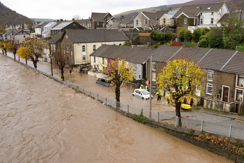
Across the South West, flooding disrupted communities and transport. There were rescues after vehicles became stranded in floodwater, and rail lines closed while floodwater and saturated ground were assessed, with sections of the network described as potentially unsafe until they had been inspected.
Flood warnings and river responses
In Shropshire, flood warnings were issued along the River Severn and its tributaries. Riverside areas and car parks in Shrewsbury closed as levels rose, and further alerts stayed in place with more heavy rain forecast. Warnings of that kind come through the national flood warning service run by the Environment Agency, informed by joint forecasting.
In Somerset, pumping was restricted by high river levels, and significant volumes of floodwater were still standing on the moors after the rainfall had eased.
Somerset was the more complicated case, and the longest-lasting of them. Flooding on the Levels and in the surrounding valleys came from river flows, surface water and high groundwater at once. Multiple flood alerts stayed in force for days. It is the clearest illustration of how local flood risk responsibilities, drainage boards and wider water management functions overlap, particularly when prolonged flooding starts to load sewer networks and pumping stations as well. Nothing there fails on its own.
Which areas of England and Wales flooded, and from what source
The flooding was not confined to one region or one source. Seven areas accounted for most of the reporting between early and mid December, and the source of the water differed in each. That matters, because the mechanism determines what a site can realistically do about it.
| Area | Main source of flooding | Reported impact |
|---|---|---|
| East Yorkshire (Holderness Drain) | Failure at a pumping station on a managed drainage network | Farmland and businesses under water for weeks |
| Monmouth, Monmouthshire | Rivers Monnow and Wye overtopping into the town centre | Nearly 200 homes and around 120 businesses affected |
| South West England | River flows and surface water on saturated ground | Rescues from stranded vehicles; rail lines closed for inspection |
| Shrewsbury, Shropshire | River Severn and its tributaries | Riverside areas and car parks closed under flood warnings |
| Somerset Levels | River flows, surface water and groundwater together | Water standing on the moors after the rain eased; pumping restricted |
| Chippenham, Wiltshire | River and surface water, on ground flooded the previous year | Repeat flood alerts and repeat preparations |
| Derwent Water, Cumbria | Sustained high lake and river levels | Flood warnings for campsites and low-lying land |
Mid December: slow recovery and ongoing impacts
By mid December the reporting had shifted. Response gave way to recovery. In several areas the floodwater did not drain away quickly, which stretched the disruption well past the rainfall that caused it.
Agricultural land, roads and business premises were still affected weeks later. In Chippenham, businesses that had been badly flooded the previous year described how heavy rain can still send the town into panic, with each flood alert triggering the same preparations. In parts of the Lake District, flood warnings were issued for campsites and low-lying land around Derwent Water as lake and river levels stayed high with further rain expected.
Impacts on communities and businesses
For independent businesses it was the timing. In Monmouth, hospitality and retail premises closed or traded partially through what should have been the strongest fortnight of the year.
- Lost trade at the worst point in the year. Premises that closed or traded partially lost the pre-Christmas fortnight most of them rely on to carry the quieter months.
- Cover that was not there. Some owners discovered only after the event that flood damage or business interruption was not covered by their policy.
- Premiums and insurability. Others raised concerns about rising premiums and whether cover would still be available at all — questions the Flood Re scheme does not answer for commercial property.
- The cost that does not appear in the claim. Clearing up, drying out and reopening takes weeks, and the premises are earning nothing while it happens.
Alongside the financial losses, residents and business owners were open about exhaustion and anxiety, particularly in places that have flooded more than once in recent years. In several locations the concern moved quickly from clearing up to what the rest of the winter might bring.
Flooding as Christmas approached
As Christmas got closer, the pressure eased in some places and persisted in others. Conditions in Wales improved after further rain, though disruption continued and there were warnings that saturated ground meant even moderate rainfall could cause problems. Elsewhere the floodwater had receded but the damage was still visible across town centres, fields and infrastructure.
At a national level, a government taskforce met in Hull to discuss readiness for the rest of the winter.
Preparedness and resilience stayed in focus nationally, inside the wider policy and funding framework led by Defra.
What the Christmas 2025 flooding means for planning and development
For anyone developing, managing land or working through a planning application, a winter like that one is a reminder that flood risk has to be understood in its local context rather than read off a national map. What that requires depends on which side of the border the site sits and what the flooding is doing.
- In England, start with the flood risk assessment. A proportionate, site-specific report prepared to the NPPF and its planning practice guidance, covering every source of flooding that affects the site rather than only the one on the Flood Map for Planning.
- Add the sequential and exception tests where they apply. Where development is proposed in an area of higher flood risk, the sequential and exception tests run alongside the assessment and have to be argued on their own evidence.
- In Wales, it is a flood consequence assessment. The same pressures are addressed through a flood consequence assessment prepared to TAN15, which asks what happens when water arrives rather than only how likely it is.
- Then the drainage. Prolonged wet periods expose the sites that depend on managed systems, pumped drainage or constrained outfalls, which is where a surface water drainage strategy has to be tested against winter conditions and not summer ones.
In areas that flood repeatedly, how a drainage condition is discharged and built can matter as much as the assessment that got the permission in the first place. A scheme that works on paper and is never implemented properly is the point at which a site becomes someone's flooding problem.
The events of December 2025 are now part of the evidence base. If you have a site affected by any of it, our consultants can prepare a flood risk assessment for planning that addresses what actually happened on the ground, and can advise on flood risk and business continuity where premises rather than permissions are the concern.
Frequently asked questions
Why did the floodwater take so long to drain away?
Because the ground was already full. A wet autumn had left soils saturated and groundwater high, so rain that fell in December had nowhere to infiltrate and ran straight to watercourses that were already high. Where land relies on pumping, high river levels also restrict how fast water can be moved away, which is what kept parts of the Somerset Levels underwater after the rain had stopped.
Does a flood like this change a site's flood zone?
Not directly. The Flood Map for Planning shows modelled probability of flooding from rivers and the sea, not a record of events, so a single flood does not by itself move a site between zones. What changes is the evidence. A recorded flood becomes a historic event that a flood risk assessment has to acknowledge and explain, and it can affect how a local authority reads the risk.
Will a flood be formally investigated and recorded?
Sometimes. Under section 19 of the Flood and Water Management Act 2010, the lead local flood authority must investigate a flood where it considers it appropriate, establish which risk management authorities were involved and publish its findings. Not every flood meets that threshold. No report does not mean no flooding, as our guide to section 19 investigations explains.
Was the December 2025 flooding covered by insurance?
Not for everyone. Some Monmouth businesses found after the event that flood damage or business interruption was not covered. Flood Re, the scheme that helps households at flood risk get affordable cover, applies to eligible residential properties only and excludes homes built since 2009, so commercial premises fall outside it entirely.
Does a wet winter affect what a drainage strategy has to show?
It affects the assumptions. Infiltration rates measured in dry ground do not hold when the water table is high, and outfalls that discharge freely in summer can be tide-locked or backed up when receiving watercourses are in flood. A strategy that has not been tested against those conditions is the one most likely to attract an objection.
About the author. Charlotte is Unda's Marketing Manager, and is completing an MSc in Marketing at the London School of Economics. Unda has been trading since 2014, is a CIWEM Business Partner with CIWEM member and chartered (C.WEM MCIWEM) consultants, and has delivered 5,000+ flood risk assessments and drainage strategies across England and Wales.
Charlotte Stone · BSc (Hons)
Latest news






One of our experienced Flood Risk Consultants will get back to you within 60 minutes
