Taff’s Well Quarry Flood: Old Mine Water and the Risk TAN15 Doesn’t Map
Estimated reading time 26 minutes
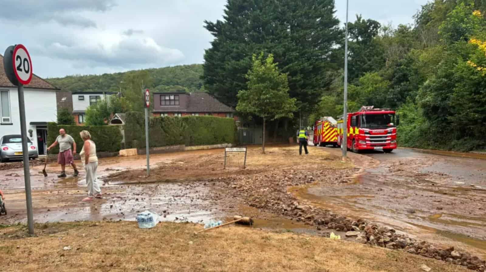
On Thursday 30th July 2026, homes in Gwaelod-y-Garth, on the north-western edge of Cardiff, flooded minutes after a planned blast at Taff's Well Quarry on the Lesser Garth, the limestone ridge above the village. The Health and Safety Executive (HSE) has since said that rock from the blast fell into one of four connected bodies of water in the old Garth Iron Mine workings and pushed a large volume of that water out through an existing mine adit. The water was known about. It had been surveyed, its volume estimated and its level recorded in papers filed with Natural Resources Wales. It appears on no flood map used to decide planning applications, and that gap is what quarry flood risk in Wales comes down to.
The water behind the Taff's Well Quarry flood was old mine water, and inside a working quarry that is handled the way quarry hazards are handled: through the operator's geotechnical assessment and design under the Quarries Regulations 1999, with HSE as the enforcing authority. Those assessments are not published. A reservoir holding the same water behind an embankment would sit on a public register, would be inspected by an independent panel engineer if designated high-risk, and would have its inundation extent shown on the Flood Map for Planning, though not as a flood zone.
This article was first published on 31st July 2026 and updated on 2nd October 2026 to add HSE's findings and the official record since August, and to correct several points in the original. The investigations are continuing.
Documents filed with Natural Resources Wales put the volume of the flooded Garth workings at about 120,000 cubic metres. No official figure has been published for how much water left the adit on 30th July.
What happened at Taff's Well Quarry on 30th July 2026?
Residents told the BBC they heard a blast at about 12:30 and, within minutes, brown water carrying mud and debris ran down through the village. Cardiff Council says 15 properties were affected and South Wales Fire and Rescue Service evacuated 13 of them. There were reports of water up to 1.5 metres (5ft) deep in some homes, the water ran through Heol Berry and Heol y Nant, and mud and debris closed Main Road and Heol Goch. Debi Bode, a Gwaelod-y-Garth resident, told ITV News the water reached the back gardens in less than a minute and was "just brown and rushing down the hill like a river". Dŵr Cymru Welsh Water confirmed the flooding had nothing to do with its pipe network, which ruled out a burst main.
Breedon, which operates the quarry, first described "an incident" at the site. The next day its GB chief executive said the incident had occurred following one of its planned blasts.
Following yesterday's incident, which occurred following one of our planned blasts at Taffs Well Quarry, our absolute priority is to support those affected.
Mike Pearce, Chief Executive Officer, Breedon GB, 31st July 2026
The statement set out the order of events. It did not accept a cause. First Minister Rhun ap Iorwerth visited on Saturday 1st August, told residents "we have your back" and said he wanted an in-depth investigation so that lessons would be learned. The Welsh Government had responded the day before through two Cabinet Ministers. Llyr Gruffydd MS, whose Rural Resilience and Sustainability portfolio covers flood risk and Natural Resources Wales, made a Written Statement to the Senedd. Siân Gwenllian MS, Cabinet Minister for Local Government, Housing and Planning, issued a press statement.
Relevant authorities will now be investigating the incident to understand exactly what happened so it would not be appropriate for us to comment further at this stage.
Siân Gwenllian MS, Cabinet Minister for Local Government, Housing and Planning, 31st July 2026
What has HSE found about the cause?
HSE's account is that the blast displaced water that was already stored inside the hill. On 5th August it told the BBC that inspectors had been underground at the Garth Iron Mine and that the rock voids holding the water, and the adit, had not been compromised. The information used in the blast design, which specialist blasting contractors developed, would be the focus of its investigation.
This is an isolated incident where a substantial quantity of rock from a planned blast entered one of four interconnected known bodies of water collected in the old iron mine workings.
Health and Safety Executive, quoted by BBC News, 5th August 2026
HSE's press release of 15th September added the context. The blast was in a development area separate from the quarry's production operations, and it was the second blast in the roof of the old Garth Iron Mine. Those blasts were designed to collapse the mine roof and open up new mineral reserves. The work had been through geotechnical assessment and design, covering the blasts and engineering mitigation measures installed in the mine, and the previous and current operators had been planning it for more than nine years. HSE is examining the geotechnical assessments, the geotechnical designs and the designs for the blast and the mitigation, and says the investigation will take many months.
The blast that preceded the flood was designed to bring down the roof of a mine that HSE describes as holding known bodies of water, in work HSE says had been through geotechnical assessment and design over more than nine years.
Three further points are on the record. HSE does not approve individual blasts; under the Quarries Regulations 1999 the operator is responsible for making sure its activities comply. South Wales Police told WalesOnline on 31st July that it was not conducting a criminal investigation and that HSE would lead, so early reports of a joint investigation no longer describe the position. And Breedon's letter of 16th September to Kiera Marshall MS calls the incident blast the third in the mine roof, where HSE says the second, and says Natural Resources Wales is also investigating, independently of HSE. Natural Resources Wales had published no news release about the incident by 2nd October, beyond statements to the media.
Was the water in the old Garth mine workings known about?
Yes, and in some detail. The Garth haematite mine was abandoned in 1884 and flooded up to the level of its tunnel, according to the national monuments record. Papers that Breedon's consultants filed with Natural Resources Wales in support of a water abstraction licence describe the workings as flooded underground "lakes" and set out what is known about them.
- Volume. A 2002 survey estimated the underground reservoir at about 1,850 square metres in area and 120,000 cubic metres in volume, measured down to 25 metres above Ordnance Datum (mAOD), according to a 2024 technical note on the register.
- Level. Water in the workings is held at the level of an adit at 91 mAOD, which the same note says drains north from the site into an unnamed watercourse. The stored water sits below that outlet and does not drain out on its own; on 30th July it was pushed out as rock fell in.
- History. In 1926 the underground lakes were pumped dry over 18 months. A licence to abstract water from the old workings for quarry use was first issued in 1968 and is no longer used.
- Dewatering. In September 2025 Natural Resources Wales issued a new licence to dewater the old mine workings, at up to 1,344 cubic metres a day, with the water returned to the River Taff.
- Planning. The 2023 permission for the quarry's lateral extension and deepening was supported by a Flood Consequences Assessment prepared in 2020. Drawings from that assessment, reproduced in the 2024 technical note, show the main sump sized to retain about 120,000 cubic metres as a worst-case inflow if the extension intersected the flooded workings.
None of this is hidden. It sits on Natural Resources Wales's public register. The documents read for this article deal with the mine water as a quarry operations matter: how much might flow into the quarry void, how to pump it and where to discharge it. The text of the 2020 Flood Consequences Assessment was not available for this update, only its drawings. Whether it, or the geotechnical assessment HSE is now examining, looked at water leaving through the adit towards homes is not known from the public record.
For anyone developing land below a working quarry or old mine, these are the records a TAN15 Flood Consequences Assessment should go looking for, because no flood map will supply them. The register shows the water was recorded. The public record does not show it being assessed as a flood source for the land downhill.
Who is investigating, and under which law?
Three public bodies, in four roles, have a part in what happened at Gwaelod-y-Garth, and each is asking a different question under a different statute. None of them owns the whole event, and each answer so far has been partial.
| Body | Role at Gwaelod-y-Garth | Legal basis | What it does not cover |
|---|---|---|---|
| Health and Safety Executive | Leading the investigation into the cause; examining the geotechnical assessments, blast design and mitigation | Quarries Regulations 1999; Health and Safety at Work etc. Act 1974 | Planning merits; flood risk to neighbouring land as a planning matter |
| Natural Resources Wales | Saw discolouration of the River Taff on 30th July and sampled the water; licenses abstraction from the mine workings; investigating separately, according to Breedon | Abstraction and impoundment licensing; environmental permitting | Quarry lagoons and tips, which are excluded from reservoir registration |
| Cardiff Council as lead local flood authority | Duty to investigate the flood and publish the findings, to the extent it considers necessary or appropriate; no investigation announced | Flood and Water Management Act 2010, s.19 | The quarry operator's conduct, because an operator is not a risk management authority |
| Cardiff Council as mineral planning authority | Planning conditions on the quarry, including its Vibration Management Plan and Noise Management Plan | Town and Country Planning Act 1990 and the conditions on its permissions; policy in Planning Policy Wales and MTAN 1: Aggregates | Health and safety inside the quarry, which is for HSE |
The Quarries Regulations 1999 are the framework HSE is applying. Part V deals with explosives, setting duties for the operator and the shotfirer and covering misfires. Part VI deals with excavations and tips. Where an excavation or tip is a significant hazard, regulation 32 requires a geotechnical assessment, and regulation 33 and Schedule 1 set out what it must contain, from site investigation records, including groundwater measurements, to cross-sections and design. Schedule 1 also requires the site survey to show old mine workings, known cave systems, springs and watercourses. Stored water is not absent from the regulations either: the definition of a tip takes in lagoons and deposits held as liquid, which brings them under Part VI as a question of stability. Groundwater held in old mine workings is not itself a tip; it comes into the regime through the geotechnical assessment of the excavation.
Two further duties reach beyond the site boundary. The operator's health and safety document must show how people in the area immediately surrounding the quarry are protected, and section 3 of the 1974 Act requires employers to protect people who are not their employees, so far as is reasonably practicable. Neither the document nor the geotechnical assessment has to be published. Residents asked for their own expert to inspect the mine workings; Breedon's 16th September letter declined while the investigations continue, and said information forming part of its operational and safety assessments could not be shared in the meantime. Vibration monitoring data remains available through Cardiff Council.
Why doesn't the reservoir safety regime cover old mine water?
Water held above a Welsh village behind a raised structure has a well-developed safety system. Under the Reservoirs Act 1975, Natural Resources Wales is the enforcement authority in Wales, and since 1st April 2016 any reservoir able to hold 10,000 cubic metres above the natural level of the surrounding land has had to be registered. Reservoirs designated high-risk must have a supervising engineer at all times and be inspected by an independent panel engineer at least every ten years. NRW's Reservoir safety in Wales report records 405 large raised reservoirs on the register at 31st March 2025, of which 277, or 68 per cent, are high-risk.
Quarries sit outside that system by design. NRW's registration guidance excludes quarry lagoons and tips regulated under the Quarries Regulations 1999, and mine lagoons regulated under the Mines Regulations 2014, and Welsh regulations made in 2016 give that exclusion statutory force. Nothing in the public record suggests the flooded Garth workings have ever been treated as a reservoir under the Act.
A reservoir holding less than a tenth of the Garth workings' estimated volume behind an embankment would have to be registered with Natural Resources Wales.
Excluding quarry water has a sound logic: the same asset should not be regulated twice, and HSE already inspects quarries. The two regimes are not equivalent, though. One produces a public register, an independent engineer, a defined inspection interval and an inundation map that planners can see. The other produces a geotechnical assessment by a specialist, repeated at least every two years where the hazard is significant and open to HSE inspection, but not published. The same problem runs through the explainers on reservoir flooding and, more closely, infrastructure flooding, where water escaping a man-made system has to be assessed site by site.
Will there be a Section 19 flood investigation?
None had been announced by 2nd October 2026, and the statements Cardiff Council's leader and cabinet members made to full council on 24th September did not mention one. Section 19 of the Flood and Water Management Act 2010 requires a lead local flood authority, on becoming aware of a flood in its area, to investigate which risk management authorities have relevant functions and whether they have exercised them, and to publish the results. The duty applies only "to the extent that it considers it necessary or appropriate".
There is no statutory threshold. The Welsh national strategy expects an investigation where 20 or more properties flood internally, and authorities can set a lower trigger. Cardiff's Local Flood Risk Strategy, adopted in May 2025, uses 20 internally flooded properties from the same source. The 15 properties affected at Gwaelod-y-Garth fall below that number, although the council can still investigate, as the explainer on what a lead local flood authority does sets out.
The statute has a further problem here. Section 19 asks about risk management authorities, and a quarry operator is not one. A narrow reading of the statutory question could find that every authority did what it should and still tell residents nothing about why their homes flooded.
- There is a precedent for reaching further. After the Skewen mine water blowout on 21st January 2021, Neath Port Talbot's section 19 report listed the Coal Authority among the relevant authorities, although it is not a risk management authority under the Act. It gave the Coal Authority an action to design and develop a mine water flood remediation scheme.
- Reports take time. Rhondda Cynon Taf's section 19 report on the Storm Dennis flooding of February 2020 at Taff's Well was issued in January 2022, nearly two years later.
- The duty is loosely defined. An independent review for the Welsh Government, published in August 2023, found that section 19 sets no purpose or content for an investigation and described the regime as largely subjective.
- Cardiff's groundwater baseline is thin. The 2025 strategy describes groundwater flood risk in the city as difficult to assess and to mitigate against.
How section 19 sits alongside the asset register duty and the Welsh reservoir provisions is covered in the article on the Flood and Water Management Act 2010.
Why does the ground at Taff's Well hold so much water?
Because the quarry is cutting into a limestone hill that has been dissolved by groundwater and hollowed out by iron mining. HSE's account points to water stored in old mine workings, not a natural conduit broken open by the blast. The first version of this article, written before HSE had said anything, speculated about karst. The geology still explains why there were water-filled voids inside the hill at all, and why groundwater flooding in this kind of ground behaves so differently from a river.
Taff's Well Quarry works dolomitised limestones of Lower Carboniferous age with considerable folding and faulting, on the Lesser (Little) Garth. Garth Hill, which gives the village its name, is Pennant sandstone. In 2009 the quarry was reported to have routinely produced up to a million tonnes of limestone a year before the downturn. The Lesser Garth holds caves as well as the old haematite workings, and the haematite occurs within the limestone itself. Quarrying on the ridge uncovered Ogof Ffynnon Taf in March 1986, and cavers later connected it to Lesser Garth Cave, which the Cambrian Cave Registry describes as lying very close to the active quarry.
Taff's Well also has Wales's only thermal spring, at about 21.6°C. Its water is thought to travel some 25 kilometres from the north crop of the coalfield, reaching depths of at least 400 metres over at least 5,000 years, before rising up the Tongwynlais Fault where it crosses the Taff. Across the region, the British Geological Survey's hydrogeology of Wales records some 80,000 dolines on the north crop alone, dye-traced links between swallow holes and springs of seven kilometres or more, and tracer velocities of three to four kilometres a day. It also records this:
Reactivation of karst conduit systems has been recorded at a number of sites.
British Geological Survey, Hydrogeology of Wales: the Carboniferous Limestone aquifer
Its example is Stormy Down Quarry, where discharge into a doline reactivated the karst system and extensive remedial work was needed during construction of the M4.
In limestone country, the water that matters for a site can be stored inside the hill, in voids that no surface flood map shows.
That is why a groundwater flood risk assessment in limestone country is a different exercise from one on a river terrace. The national maps covered in the review of groundwater flood risk maps in the UK model water rising through the ground; none of them is built to show water stored in old workings. Changing how water moves underground relocates it rather than removing it, the principle at the centre of the Upper Tribunal case in groundwater, heritage and the cost of getting flood risk wrong.
What does TAN15's Flood Map for Planning show, and what does it miss?
Technical Advice Note 15, published and in effect from 31st March 2025, replaced the 2004 TAN15 and TAN14 on coastal planning. Its starting point is NRW's Flood Map for Planning. Groundwater gets a mention in passing: as one of the sources a Strategic Flood Consequences Assessment and an individual Flood Consequences Assessment should consider, and among the risks an authority must understand before allocating land in a Defended Zone. TAN15 gives no map, zone or method for it. It deals with canals, dams and reservoirs as artificial sources and has nothing on mine water, quarry voids or karst.
| Flood source | Mapped for TAN15 decisions? | Where it is dealt with |
|---|---|---|
| Rivers and the sea | Yes | Flood Zones 1, 2 and 3 |
| Surface water and small watercourses | Yes | Zones 2 and 3, mapped since the map's release in 2021 and given planning effect from 31st March 2025 |
| Areas behind flood defences | Yes | TAN15 Defended Zones; residual risk still has to be assessed |
| Reservoirs | Shown, but not as a flood zone | Reservoir inundation maps for reservoirs under the Reservoirs Act; quarry lagoons and tips are excluded from registration |
| Groundwater | No | Site-specific assessment in the Flood Consequences Assessment |
| Mine water, quarry voids and karst | No | No category in TAN15 |
| Ground stability and old workings | No | Outside the Flood Map for Planning; the Mining Remediation Authority (formerly the Coal Authority) is consulted on development in defined coal-mining areas |
Natural Resources Wales responded to around 2,100 planning consultations in 2024–25 where the local planning authority had identified flood risk as a potential constraint, according to its flood risk management annual report. Through the Flood Map for Planning it does not tell an applicant whether a site sits below a working quarry or above old workings. The same kind of gap showed when the Llangollen Canal embankment at Whitchurch in Shropshire collapsed in December 2025: the Canal & River Trust's initial findings traced it in part to a long-term, deep-seated leak beneath the canal bed that its inspection regime could not detect.
Does Wales already treat extraction ground as a hazard?
It does, outside the planning system, through tip-safety law that runs back to Aberfan. On 21st October 1966 a colliery spoil tip, built over a natural spring, slid onto Pantglas Junior School and the houses around it, killing 144 people, 116 of them children. The Tribunal of Inquiry found the disaster could and should have been prevented. It led to the Mines and Quarries (Tips) Act 1969, the first legislation dealing specifically with the safety and stability of mine and quarry tips.
| Year | Law or event | What it did |
|---|---|---|
| 1966 | Aberfan disaster | A colliery spoil tip failed above the village, killing 144 people, 116 of them children |
| 1969 | Mines and Quarries (Tips) Act | Required tips at working mines and quarries to be made and kept secure under inspectorate oversight, and gave local authorities powers over disused tips |
| 2015 | Mines Regulations 2014 in force | Repealed sections 1 to 7 of the 1969 Act, on tips at working mines and quarries |
| 2025 | Disused Mine and Quarry Tips (Wales) Act | Royal Assent on 11th September 2025; a Wales-wide system for disused coal and non-coal tips |
| 2027 | Disused Tips Authority for Wales | Due to be established on 1st April 2027 as the body responsible for the safety of disused tips in Wales |
The Disused Mine and Quarry Tips (Wales) Act 2025 will, once fully in force, take Wales out of the disused-tips part of the 1969 Act. Wales has 2,589 disused coal tips on the Welsh Government's Spring 2026 data, rated in categories A to D and R. The highest-risk category D tips are inspected twice a year and category C tips once a year. Rhondda Cynon Taf has 332 of them, including 29 of the 85 category D tips in Wales. In March 2026 the Welsh Government put its own investment in coal tip safety over the last Senedd term at over £110m, alongside £143m committed by the UK Government.
Taff's Well is a working quarry, and flooded mine workings are not tips, so none of that law applies here. The pattern is still telling. Where Wales has decided that ground left by extraction is a hazard in its own right, it has built a register, an authority and an inspection cycle. Where the ground is still being worked and the hazard is stored water, the assessment stays with the operator and HSE.
What did residents complain about before the flood?
In a report published on 3rd March 2026, five months before the flood, The Cardiffian said residents of Pentyrch and Gwaelod-y-Garth, some of them on Heol Berry, were grouping together over damage they linked to blasting. Blasts were taking place every Wednesday, with occasional ones on Fridays, and residents described cracks in walls and ceilings. Breedon said it had carried out numerous tests over the years and there was no link between the cracks and the blasts. Cardiff Council said the quarry was complying with its approved Vibration Management Plan (condition 18) and Noise Management Plan (condition 23), pointed residents to planning enforcement if they believed the consent was being breached, and said damage claims should go to the operator.
Blast vibration at Taff's Well was monitored under an approved plan and reported as compliant. Nothing in the public record links stored mine water to that complaints process.
This is a point about what was being measured, not an allegation. Nothing in the March reporting suggests anyone foresaw a flood, and Breedon's position was that there was no link between the blasting and the cracks. A monitoring regime built around vibration and noise limits measures vibration and noise. It cannot tell anyone what a blast might do to water stored a short distance away.
What should a site-specific assessment check near quarries and old mines?
Quarry flood risk in Wales is less a mapping problem than an information problem. Much of the data that matters exists: blast designs, dewatering volumes, mine surveys, the operator's geotechnical assessment. Some of it sits on Natural Resources Wales's public register; the rest stays with the operator and HSE, and a neighbouring applicant has no automatic access to it. The practical response is to treat the ground as a named flood source and to state clearly what could not be found out.
- Check historic mapping and mining records. Old Ordnance Survey editions, Coflein for non-coal mines and quarries, the Mining Remediation Authority's map viewer for coal, and, once it is established, the Disused Tips Authority for Wales establish what has been worked or tipped on or near a site.
- Commission a geotechnical desk study. Made ground, backfill and landslip are what the free ground-conditions checker flags from British Geological Survey mapping before infiltration or foundation design is fixed; old quarry backfill is one of the examples of made ground it names.
- Treat karst and worked limestone as a groundwater question. Where the bedrock is Carboniferous Limestone, conduit flow, swallow holes and old workings need a design groundwater position built from records and monitoring, not an assumption.
- Search the public register for the neighbour's water. Abstraction licences, discharge permits and the hydrogeological reports behind them are on Natural Resources Wales's register, which is where the volume, level and dewatering plans for the Garth workings can be read. The operator is not a statutory consultee on a neighbour's application, so this has to be looked for.
- Build hidden-hazard scenarios into the Flood Consequences Assessment. Alongside the breach, overtopping and blockage scenarios TAN15 expects where a site benefits from flood defences, describe what happens if water stored in old workings or voids upslope is released suddenly.
- Talk to Natural Resources Wales early. It reviews flood risk as a statutory consultee, and how it views an extractive site next door is better known before submission than after.
What does this mean for developers and planners near quarries and mining land?
TAN15 puts the onus on the applicant: planning authorities should permit development only where the developer has shown that the risks and consequences of flooding are manageable, and the Flood Map for Planning is where that evidence starts, not where it ends. Wales' £85m flood and coastal erosion risk management programme for 2026–27, the largest annual allocation the Welsh Government has made, pays for river schemes, coastal works and natural flood management.
There is a live planning context at this site too. In the 2021 call for sites for Cardiff's Replacement Local Development Plan, Breedon put forward a 4.6-hectare extension to Taff's Well Quarry. The council's candidate site assessment records the site as having extant planning consent, and permissions granted in 2023 and 2025 released about seven million tonnes of further reserves. The same council looks at this flood as mineral planning authority, lead local flood authority and highway authority for Heol Goch.
Public flood-defence funding pays for the risk that can be seen. Nothing in the 2026–27 Welsh programme looks for the water stored inside the hill above a development site.
For a site near current or former quarrying or mining, a TAN15-compliant Flood Consequences Assessment should look past the Flood Map for Planning to the licence papers, mining records and ground conditions the map leaves out. Where the geology governs the risk, a groundwater flood risk assessment with hydrogeological input is the right starting point.
Frequently asked questions
Who pays when a quarry operation floods homes?
That depends on what the investigations find, and it is a question for a solicitor rather than a flood risk consultant. On 21st August the Welsh Government told the Senedd it had not yet discussed financial support with Breedon and that compensation would be a matter for Breedon and its insurers if the investigation reached those conclusions. Breedon's 16th September letter lists emergency accommodation, clean-up, help with insurance arrangements and access to a major-incident support service, and announces no compensation scheme. The nearest Welsh comparison involved a public body. After the Skewen blowout in 2021 the Coal Authority ran a support scheme that capped garden and outdoor reinstatement materials at £2,000 excluding VAT, and stated it had no legal liability for coal mine water discharges; the policy was withdrawn in June 2024, when the scheme was listed as closed. A private operator's position is different.
Was the floodwater contaminated?
Sampling by Natural Resources Wales and Shared Regulatory Services, of the debris and of the water that reached the River Taff, found no issues and no significant or ongoing water quality impacts, Cardiff Council reported on 10th September. Breedon says the water was broadly consistent with water that could be discharged to the Taff under an environmental permit. Other contaminants have been raised in the Senedd as residents' concerns; none has been reported as a finding.
Has a blast released water into a Welsh community before?
The closest Welsh case is underground. At Gleision Colliery near Cilybebyll on 15th September 2011, water flooded the drift shortly after a routine blast at the coal face and four miners drowned. The prosecution's case was that the blast broke through to old flooded workings; the defence's expert argued the water more likely came from another part of the mine, and the mine manager and the operating company were acquitted of manslaughter in June 2014. A full inquest is expected to be heard in 2027. Inrush from old workings is a recognised hazard in South Wales for that reason.
How close to homes is a quarry allowed to operate in Wales?
Minerals Technical Advice Note 1 (2004) sets minimum buffer zones of 200 metres around hard rock quarries and 100 metres around sand and gravel workings, measured from the edge of the extraction and processing area, unless there are clear and justifiable reasons to reduce them. Conditions on each permission then apply. A Senedd petition (P-06-1476) calling for a mandatory 1,000-metre buffer around all new and existing quarries gathered 11,473 signatures and was debated in Plenary on 4th June 2025. It was closed as completed in 2026 without the distances changing.
Can a planning application be refused over a neighbouring quarry's water management?
In principle, yes. TAN15 requires a Flood Consequences Assessment to consider all sources of flooding, including groundwater, and a planning authority can refuse where the consequences are not shown to be manageable. In practice it is rarely tested, because the risk is not mapped, the operator is not a statutory consultee and the applicant has no automatic access to the operator's geotechnical records. The realistic route is to assess it properly in the Flood Consequences Assessment, using whatever the public register holds, and to set out what is known and what is not.
About the author. Edward is a co-founder and Director of Unda with 20+ years in flood risk and drainage, and a national-press commentator on flooding. Unda has been trading since 2014, is a CIWEM Business Partner with CIWEM member and chartered (C.WEM MCIWEM) consultants, and has delivered 5,000+ flood risk assessments and drainage strategies across England and Wales.
Edward Bouët · BSc (Hons)
Latest news






One of our experienced Flood Risk Consultants will get back to you within 60 minutes
