How flood defence works can raise groundwater, and who pays for the damage
Estimated reading time 22 minutes
Flood defences are built to keep water out. Sometimes they change where the water goes instead.
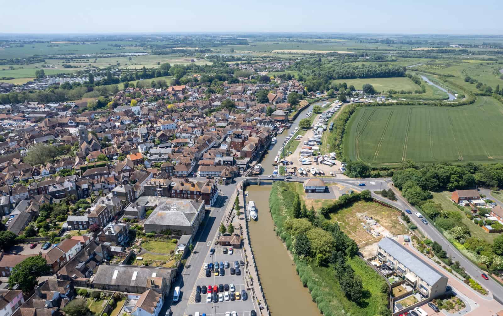
The relationship between flood defence works and groundwater has now been tested twice in the Upper Tribunal, and both decisions went against the Environment Agency. In Brookhouse v Environment Agency, the Tribunal found that a flood defence scheme at Sandwich in Kent raised groundwater beneath The King’s Lodging, a Grade II listed fifteenth-century house, and that the rise damaged the building. In June 2026, after an eight-day hearing, it decided what that damage was worth. The case has been reported at around £3.3m.
Few published judgments set out in this much detail how a defence scheme can move water underground rather than remove it. This article covers the mechanism the Tribunal accepted, the evidence gap that shaped both decisions, why historic fabric fails first under a raised water table, and the compensation route when public flood defence works injure private property.
The Tribunal found groundwater at The King’s Lodging had risen by between 0.5m and 1m since the works, and probably nearer to 1m.
What the Upper Tribunal decided about The King’s Lodging
The Tribunal decided the case in two stages. In November 2023 it found that the Environment Agency’s flood defence works had raised groundwater at The King’s Lodging and had damaged the house. In June 2026, after a further eight-day hearing in March, it determined the amount. Liability for some of the garden damage had already been accepted.
| Causation decision | Quantum decision | |
|---|---|---|
| Citation | [2023] UKUT 282 (LC) | [2026] UKUT 209 (LC) |
| Date | 30 November 2023 | 12 June 2026 |
| Question | Did the works damage the house? | What is the damage worth? |
| Outcome | Groundwater rose by 0.5m to 1m, probably nearer 1m, and damaged the building | Compensation determined across statutory and contractual heads |
The building is a fifteenth-century timber-framed three-storey dwelling on the River Stour, listed at Grade II and once used by Henry VIII. The works were part of the Sandwich tidal defence scheme: a new sheet-piled wall with infill material and a concrete capping layer, built alongside an older dock wall on the claimants’ land.
Both judgments are published in full. The 2023 decision on causation is at [2023] UKUT 282 (LC), also reported on BAILII and summarised in counsel’s note on the Upper Tribunal decision. The 2026 decision on quantum is at [2026] UKUT 209 (LC). The dispute also drew national press coverage. Between them the two judgments carry a level of hydrogeological detail that rarely reaches a published decision, which is what makes the case useful beyond Sandwich.
How can flood defence works raise groundwater levels?
A flood defence raises groundwater when it obstructs the path water was using to drain away. Water arriving from the river at high tide passes into the ground behind the defence, but a barrier that stops the tide coming in also stops the same water flowing back out. Level by level, tide by tide, the water behind the structure sits higher than it did before.
At The King’s Lodging the Tribunal accepted a specific version of this. The new wall was semi-permeable. Water flowed at high tide into the material between the new wall and the old dock wall, then through the old wall, which was damaged, into the ground behind it. What it then met was a buried revetment, the remains of a still older wall below ground level. Water overtopped that buried revetment at spring tides but not at neap tides, and once over it could not flow back freely, because the ground on the river side was already under pressure from the river.
The Tribunal put the hypothesis plainly. Water got over the buried revetment and then drained back “only very slowly at extremely dry periods”. None of this produced a flood. It produced a permanently higher baseline, with the ordinary seasonal swing riding on top of it, so the wet-season peak the building had lived with for five centuries now started from a metre further up.
Borehole monitoring showed groundwater near the house at around 2m AOD, against roughly 1.3m AOD recorded before the works.
The figures matter because they are small. A rise of under a metre in Ordnance Datum terms would barely register on most development sites. Under a fifteenth-century timber-framed house with shallow footings and no damp-proof course, it was enough to require the replacement of external stonework and brick and the restoration of timber posts damaged by water at their base.
This is why the case sits with groundwater flooding rather than river flooding, despite the river being a short distance away. Where a site has that geometry, with a new or proposed defence, a historic structure and a below-ground element in the same place, a groundwater flood risk assessment establishes whether the interaction exists before anybody builds anything.
Why this was a groundwater case, not a river flooding case
No river water ever entered the house. The damage came from water arriving below it, over years, and the Tribunal reached that conclusion from five strands of evidence rather than any single dataset. Consistent indirect evidence, rather than one decisive measurement, is what a claimant is left with when nobody recorded the baseline.
- Historic and pre-works evidence. A 2007 site investigation put groundwater at about 1.3m AOD, plus or minus 0.2m, with no water found in a trial pit at 1.6m AOD.
- Physical site behaviour. The swimming pool, its base at about 1.6m AOD, stood empty for three weeks during relining in May 2004 with no groundwater seen.
- Post-works monitoring. Boreholes near the house showed levels held above 1.75m to 2m AOD and rising to 2.5m AOD in heavy rainfall.
- Changed ground conditions. The garden became persistently waterlogged, with saline and anaerobic conditions consistent with a raised groundwater regime.
- Design assumptions. The Agency and its contractor expected groundwater at 1.1m or 1.2m AOD, reasoning from topography and river level. The measured position was roughly a metre higher.
Taken together these led the Tribunal to find, on the balance of probabilities, that levels had risen by between 0.5m and 1m and probably nearer to 1m. It did not accept that timing alone proved causation, and it did not accept that the building’s age explained the damage. Surveying and engineering evidence described what had happened to the fabric; the hydrogeology explained why.
The swimming pool was the most telling single fact. A pool cannot be drained and maintained if the water table around it sits above its base.
Rivers, the sea and surface water are mapped nationally on the Flood Map for Planning and the long-term flood risk service. Groundwater is not, which is why no single water table map covers the UK and why screening has to be assembled from geology, British Geological Survey susceptibility data and the local strategic flood risk assessment. It is also why the communities affected by groundwater flooding are so poorly served by the maps most people reach for first.
Why the missing survey damaged both sides
The Environment Agency did not commission a hydrological survey before the works began. The Tribunal called this “the evidential tragedy in this case”, and its consequences fell on the Agency at least as heavily as on the claimants. Without a baseline, the Agency spent the hearing disputing the accuracy of assumptions its own contractors had made before construction started.
The wisdom of carrying out a hydrological survey before starting work on an historic and sensitive property next to a river is obvious and the decision not to do so may now appear to be regrettable, but it was not a breach of any obligation on the part of the respondent.
Upper Tribunal (Lands Chamber) · Brookhouse v Environment Agency [2023] UKUT 282 (LC), para 116
Two details are worth separating. The survey was recommended in the Design and Access Statement submitted with the application, but it was not required. The listed building consent condition obliged the Agency to work in accordance with that statement, which is not the same as obliging it to follow a recommendation inside it. The decision not to survey was, as the Tribunal put it, not a breach of any obligation.
That is the procurement gap. Nothing in the consenting process compelled a survey, even though a pre-works groundwater monitoring exercise on a scheme of this kind costs a fraction of a per cent of the scheme budget and would have settled in three months what then took two hearings and nine years to establish.
The Tribunal’s assessment was blunt: the Agency was left “arguing strenuously against the accuracy of the assumptions that it made and that its expert contractors made before starting work”.
The lesson for anyone commissioning works near a sensitive structure is not that a survey protects the neighbour. It is that a survey protects the promoter. A defendant with a good baseline dataset can show what did and did not change. A defendant without one argues about inference, which is a much worse place to be, and it is the same reason technical rigour matters in flood risk assessment long before anything is contested.
What a pre-works groundwater baseline should contain
A defensible baseline is a monitored record of how groundwater behaves at the site across a full range of conditions, not a single reading. It needs enough instruments to show the shape of the water table, enough duration to catch the seasonal peak, and enough logging frequency to separate tidal response from rainfall response. On a tidal site, that last point is what makes the dataset useful.
- An instrument array, not a borehole. Piezometers or dipwells positioned to show the shape of the water table across the site, including at least one on each side of any proposed barrier.
- Continuous logging. Automatic loggers at an interval short enough to resolve a tidal cycle. Manual dip readings once a month will not separate a tidal response from a rainfall response.
- A full wet season. Monitoring that runs through the winter peak, roughly November to May. A summer record tells you almost nothing about the level that governs.
- Levelled to Ordnance Datum. Every reading tied to a surveyed datum, usually from the same topographical survey that fixes floor levels, so the numbers can be compared with footings and with any later measurement.
- Rainfall and river or tide data alongside. Groundwater readings mean little without the drivers that explain them, and the regional picture in the British Geological Survey depth-to-groundwater data is worth having as context.
- A conceptual model. A written account of where the water comes from, where it goes, and what the proposed works will change about that. This is the part that turns data into a design groundwater level.
The case gives a clear benchmark for what “good enough” looks like. Boreholes installed at the property in February 2018 were monitored continuously from 28 February to 9 May. The Tribunal described the resulting dataset as being “of such good quality they have given rise to rather more agreement than disagreement”, which in a dispute with this many experts in it is close to the highest praise available.
Continuous monitoring from 28 February to 9 May 2018 produced the only dataset in the case that both sides largely accepted.
Three months of continuous data is not an unreasonable ask on a multi-million-pound scheme, and it is broadly what the planning system already demands where infiltration drainage is proposed or where groundwater is raised in a planning application. It is the works-promotion side that has no equivalent habit, which is also why poorly timed monitoring is such a common cause of delay.
Where no pre-works data exists, a baseline can still be reconstructed: construction records for below-ground structures, the behaviour of drains and pools, vegetation and ground conditions, and the professional expectations that applied at the time. Slower, weaker and far more expensive than measuring, but not hopeless.
Why historic buildings fail first under a raised water table
Traditional buildings are designed to let moisture move through them and out again, which works well until the water arrives faster than the fabric can shed it. Lime mortars, renders and plasters have a large connected pore system and disperse moisture by design. Raise the water table under shallow, permeable footings and that same system carries water upward and holds it there.
- No damp-proof course. A building predating the practice has nothing to interrupt water rising through the wall base.
- Shallow and irregular footings. Rubble and stone footings sit within the zone a rising water table reaches first, and lose bearing capacity as the ground saturates.
- Breathable materials. Lime mortar and plaster move moisture through a connected pore system, which carries water up as readily as it lets it out.
- Salt crystallisation. Salts dissolved in groundwater crystallise as the surface dries, spalling the face of brick and stone.
- Timber in contact with damp ground. Posts and sole plates bedded near ground level decay where they stay wet, which is what happened to the timber frame here.
- Earlier cement repairs. Cement pointing and renders trap moisture in the wall and concentrate the salt damage behind them.
Historic England’s technical guidance on masonry buildings and flooding sets out the mechanism, and its companion note on flood types and understanding a building’s risk covers the geotechnical side. As saturated masonry dries, dissolved salts crystallise near the surface, and where an impermeable coating traps them inside, the face of the brick or stone spalls away. Cement mortar makes it worse, because it “holds the moisture in the masonry for longer and causes salts to crystallise within the historic materials”. Drying is slower through England’s wetter months, which extends the exposure to freeze-thaw damage as well.
Damage from a raised water table arrives as persistent damp, salt migration, timber decay and slow structural movement, not as a flood.
At The King’s Lodging the garden became persistently waterlogged, with saline and anaerobic conditions consistent with a raised groundwater regime, and the house needed stonework and brick replaced and water-damaged timber posts restored. None of it would have been visible on the day the wall was finished. That is why a heritage asset next to a proposed defence deserves more scrutiny than its scale suggests, and the same reasoning applies to any below-ground room or basement conversion.
Cut off the water, or pump it forever?
The largest question at the quantum stage was engineering, not law: what would actually fix it. Two schemes were put forward. One drained the water away after it arrived. The other stopped it arriving. The Tribunal preferred the second, and its reasoning is the most transferable part of the judgment.
| Pumped drainage trench | Sheet-piled cut-off | |
|---|---|---|
| What it does | Intercepts water after it arrives and pumps it away | Blocks the flow path so water does not arrive |
| Form | Trench about 30cm wide and 2.5m deep, parallel to the river | Dock wall demolished and replaced with sheet steel piles driven to match the new defence |
| Operating burden | Permanent pumping, power and maintenance | None once built |
| Tribunal’s view | Probably ineffective; addressed the symptom, not the cause | A targeted solution that completes what the Agency started |
The rejected scheme was a drainage trench with a pumped discharge. The Tribunal found it would probably be ineffective, and said why in a sentence any consultant should keep: the assurance that the water will drain away again “is not much comfort; the remedial objective is to stop it getting in”.
The preferred scheme demolishes the dock wall and replaces it with sheet steel piles driven deep enough to match the new defence, creating a cut-off. The Tribunal called it “a targeted solution, addressing the problem that has been identified”, and noted that it “completes what the respondent started”.
The Tribunal was “wholly unconvinced” by the pumped drainage scheme, on the ground that it addressed the symptom rather than the cause.
There is a wider point here about permanence. A passive cut-off has no operating cost and nothing to fail. Permanent dewatering hands a listed building a maintenance liability, an energy bill and a failure mode in perpetuity, and it assumes somebody is still running the pump in thirty years. Somebody usually is not. It is the same argument that runs through residual risk behind any defence: a structure that has to keep working is not the same as a risk that has gone.
Compensation for damage caused by flood defence works
Where the Environment Agency exercises its flood defence powers and injures somebody, the statute requires it to pay. Paragraph 5(1) of Schedule 21 to the Water Resources Act 1991 provides for full compensation, and disputes over the amount are determined by the Upper Tribunal (Lands Chamber). This is a statutory right, not a negligence claim: there is no need to show that the works were badly designed or badly built.
Where injury is sustained by any person by reason of the exercise by the appropriate agency of any powers under section 165(1) to (3) above, the appropriate agency shall be liable to make full compensation to the injured person.
Water Resources Act 1991 · Schedule 21, paragraph 5(1)
The powers are at section 165 of the Water Resources Act 1991, the compensation provision at Schedule 21. Which body held which power decides the route: our guide to who is responsible for managing flood risk in England, the explainer on main rivers and ordinary watercourses and the note on the Environment Agency’s role in flood risk and planning all bear on it, as do the riparian duties attaching to land beside a watercourse.
The Brookhouses brought two claims together: the statutory reference under Schedule 21, and an arbitration of a contractual claim under a deed signed with the Agency on 6 November 2014, before the works began. That deed carried its own obligations, including a covenant to survey the drains. Anyone who has signed an agreement with a promoter ahead of a scheme should read it again in that light, and the same goes for any flood risk activity permit conditions attached to works in or near a watercourse.
| Statutory claim | Contractual claim | |
|---|---|---|
| Basis | Water Resources Act 1991, Schedule 21, paragraph 5(1) | Deed of 6 November 2014, signed before the works |
| Trigger | Injury caused by the exercise of flood defence powers under section 165 | Breach of the obligations the parties agreed |
| Measure | Full compensation | Damages under the deed |
| Decided by | Upper Tribunal (Lands Chamber) | Arbitration, heard together with the statutory reference |
“Full compensation” has an established meaning: putting the claimant fairly and reasonably back in the position they were in before the damage. For a listed building that produces an awkward result, because the cost of putting a heritage asset back is not governed by what the asset would sell for. The unblighted value of The King’s Lodging was assessed at £1,850,000, and the compensation determined ran well above it.
Investigative costs are recoverable. The cost of finding out what went wrong is part of the loss, not a cost of pursuing the claim.
That last point is the practical one. Establishing the mechanism took boreholes, monitoring, hydrogeological interpretation and expert evidence over several years. Property owners often assume investigation is money they will never see again. On these facts it was not.
Has a scheme changed the groundwater under your building?
Our hydrogeologists and flood risk consultants establish what the water is doing, and why. Quote back within 60 minutes.
Start a quoteWhat to do if you think scheme works have raised your groundwater
Start measuring. The single most valuable thing a property owner can do is establish what the groundwater is doing now, because every month without data makes the eventual comparison harder and the argument weaker. The order of the remaining steps matters less than starting the record.
- Install monitoring. Piezometers, levelled to Ordnance Datum, logged continuously. Start whatever the season is; a partial record beats none.
- Gather the historical evidence. Construction drawings, drainage records, previous site investigations, photographs, and anything documenting below-ground work such as pools, cellars, drains and foundations.
- Establish the mechanism. A hydrogeological assessment of what changed and why, tested against the scheme’s own design assumptions and drawings.
- Get the fabric assessed alongside it. A conservation-accredited surveyor should record the damage while the hydrogeology explains it. The two pieces of evidence work together.
- Notify the promoter early. Statutory compensation is a claim against the body that exercised the powers, and the sooner it is on notice the better the evidential position.
- Take legal advice on the route. Whether the claim runs under the Water Resources Act, the Land Drainage Act or an agreement signed before the works depends on who did what.
Two cautions. Damp in an old building has several possible causes, and rising groundwater has to be separated from penetrating damp, condensation and a failed drain before anybody writes a letter. That diagnosis is a technical exercise, not a visual one. And a property-level flood barrier will not help, because it is designed to resist water arriving across the ground, not from beneath it. If you are buying rather than defending, the same questions belong in a flood risk survey before purchase, and our guide to understanding flood risk before you buy covers what to ask.
Unda’s hydrogeologists and chartered flood risk consultants work on exactly this interaction, whether the question is a proposed scheme next to a sensitive building, an existing problem that needs a mechanism, or evidence for a claim. If groundwater has been raised on your site, or you are promoting works that could raise somebody else’s, a specialist groundwater flood risk assessment is where that gets established. Where the question is a development rather than a dispute, it belongs inside the wider flood risk assessment for the site, or the flood risk assessment for planning if an application is in play. Call 01273 057 258 or email enquiries@unda.co.uk.
Frequently asked questions
Will a flood barrier or door guard stop groundwater getting in?
No. Property flood barriers, door guards and airbrick covers are designed to resist water arriving across the ground surface. Groundwater arrives from beneath, through floors, footings and the wall base, and it is under pressure. A barrier bolted to the outside of the building has nothing to seal against. Where groundwater is the source, the answer is to lower the water table or cut off the path feeding it.
Do the national flood maps show groundwater risk?
No. The Flood Map for Planning, the public long-term flood risk service and NaFRA2 all cover rivers, the sea and surface water. None of them maps groundwater, even though the National Planning Policy Framework and its planning practice guidance on flood risk require all sources of flooding to be assessed. Screening has to be assembled from British Geological Survey susceptibility data, borehole records and the local strategic flood risk assessment, and none of those gives a property-level answer.
What if the works were carried out by a council or a drainage board?
There is an equivalent provision. Section 14 of the Land Drainage Act 1991 gives drainage boards and local authorities their general drainage powers, and provides that where injury is sustained by reason of the exercise of those powers, the board or authority is liable to make full compensation. Disputes over the amount go to the Upper Tribunal, as they do under the Water Resources Act.
How can you prove groundwater levels rose if nobody measured them beforehand?
By reconstructing the previous position from indirect evidence, which is what happened here. Records from below-ground construction give a hard ceiling on where the water table sat. A swimming pool base at around 1.6m AOD, dry in a wet spring, is a measurement even though nobody intended it as one. Add earlier site investigations, the behaviour of drains and vegetation, and what professionals would have expected of that ground, and a tribunal can find a baseline on the balance of probabilities. It is slower, less certain and considerably more expensive than monitoring.
Could a smaller scheme than a tidal flood wall do the same thing?
Yes. The mechanism is obstruction, not scale. Anything that penetrates the water-bearing layer can dam groundwater: a cut-off wall, sheet piling for a basement, a deep highway drain, piled foundations across a flow path. The risk is highest where the structure runs across the direction groundwater was travelling, and where the ground behind it has nowhere else to go.
Does this mean flood defence schemes generally cause groundwater problems?
No, and the Tribunal did not suggest it. The finding was about a specific flow path at a specific site, established through a damaged wall and a buried structure that nobody had accounted for. The transferable point is narrower and more useful: a defence changes how water moves through the ground around it, and whether that matters is a question to be answered before construction rather than after.
About the author. Edward is a co-founder and Director of Unda with 20+ years in flood risk and drainage, and a national-press commentator on flooding. Unda has been trading since 2014, is a CIWEM Business Partner with CIWEM member and chartered (C.WEM MCIWEM) consultants, and has delivered 5,000+ flood risk assessments and drainage strategies across England and Wales.
Edward Bouët · BSc (Hons)
Latest news






One of our experienced Flood Risk Consultants will get back to you within 60 minutes