Shropshire Canal Failure: What the Whitchurch Canal Breach Means for Flood Risk and Planning
Estimated reading time 22 minutes
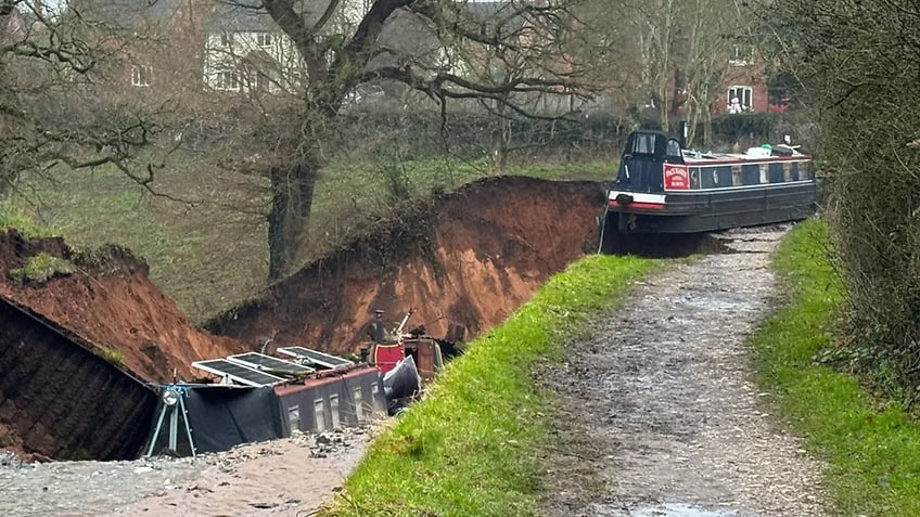
A canal breach is the sudden failure of the bank or bed that holds a canal's water, and it matters for planning because most of Britain's canals sit above the land around them. When one gives way, the water does not rise. It arrives. The failure of the Llangollen Canal near New Mills Lift Bridge, on a raised length of canal passing to the west of Whitchurch, Shropshire, in the early hours of 22 December 2025 is the clearest recent illustration: a raised embankment collapsed, a void roughly 50 metres square opened in the channel, and two narrowboats were washed into it.
Nine months on, the cause is understood, the repair is most of the way through its programme, and the episode has become something more useful than a news story. It is a worked example of a risk the planning system already recognises but rarely has to look at directly.
The Canal & River Trust manages 2,000 miles of waterway and more than 10,000 principal assets, most of them built more than two centuries ago. At 31 March 2026, 14.20% of those principal assets sat in the two lowest condition grades, up from 13.77% a year earlier.
If your site sits below a raised length of canal, that residual flood risk belongs in a flood risk assessment for planning, whether or not the canal appears on any flood map.
What is a canal breach?
A canal breach, sometimes reported as a canal burst or a canal bank collapse, is an uncontrolled escape of water through the structure that contains it: the embankment, the bed, or one of the engineered features built through them, such as a culvert, lock or weir. It is classed as infrastructure flooding: the failure of a man-made system built to hold water, rather than a natural watercourse exceeding its banks.
The distinction is not academic. A river floods because more water arrives than the channel can carry, and it does so on a probability that can be modelled from rainfall and catchment behaviour. A canal is a level, artificial channel fed from reservoirs and feeder streams, and it holds a broadly constant volume. It does not flood because it fills up. It floods because something holding it in fails.
- Constant level, not variable flow. A canal is engineered to hold a set water level, so the trigger for flooding is structural failure rather than a rainfall event.
- Often raised above the surrounding land. Where a canal crosses a valley or a dip it runs on an embankment, which means the water sits above the ground it would flood.
- Held by structures, not geology. Bed lining, embankment fill, culverts and weirs are all things that can degrade, and most of them are Georgian or Victorian.
- Owned by a body, not the state. Canals are managed by navigation authorities, and asset information sits with the owner rather than in any national dataset. That also puts them outside the main river and ordinary watercourse classification that governs most channels.
- Rarely modelled. Canal breach is almost never represented in the national flood mapping a planning application starts from, in the way surface water flooding now is.
Do canals flood?
Yes, canals flood, but not in the way rivers do. The two realistic mechanisms are breach, where the structure fails and releases the channel's water into the land below, and overtopping, where more water enters the canal from feeders, land drainage or intense rainfall than its overflow weirs can shed. Both are uncommon. Both can release a large volume very quickly, because the water is already sitting above the ground it will reach.
A canal in normal operation is a well-behaved thing. It is fed at a controlled rate, its level is regulated by weirs and paddles, and boaters notice the level change by inches. The reason canals are not a routine flood source is that they are actively managed, not that they are inherently safe. That management is what an assessment has to interrogate.
In the year to 31 March 2026 the Canal & River Trust recorded 43 customer incidents arising from infrastructure failure across its network, down from 55 the year before.
Five ways a canal embankment fails
Canal failures are not one thing. The recent UK record shows at least five distinct mechanisms, and they matter because each one produces a different flood behaviour on the ground below.
| Location | Date | Mechanism | What the record shows |
|---|---|---|---|
| Whitchurch, Llangollen Canal | 22 December 2025 | Internal erosion beneath the bed | Undetected long-term, deep-seated leak eroding material below a steep, high, sand-built embankment |
| Little Bollington, Bridgewater Canal | 1 January 2025 | Slope failure after prolonged rainfall | Around 90mm of rain over the New Year period; nearly 1,000 people evacuated; canal privately owned, not a Trust asset |
| Bosley, Macclesfield Canal | March 2025 | Cross-drainage structure failure | Damaged wall of a culvert carrying a stream beneath the canal; £350,000 repair, reopened 25 June 2025 |
| Muiravonside, Union Canal | August 2020 | Overtopping in extreme rainfall | Described by Scottish Canals as a one-in-240-year storm; roughly 30 metres of embankment lost |
| Middlewich, Shropshire Union Canal | March 2018 | Operational error | Lock paddles left open; repair reported at around £3m |
Read across that table and a pattern emerges that a flood risk assessment can actually use. Two of the five failures had nothing to do with rainfall at all. One was a structure buried inside the embankment. One was human. Only two would have been picked up by asking the obvious question: how much rain fell that week?
What caused the Whitchurch canal breach
The Whitchurch breach was caused by a slow, hidden leak beneath the canal bed, not by weather or an obvious defect. On 31 March 2026 the Canal & River Trust, which owns and operates the Llangollen Canal, published the initial findings of its investigation.
At this stage the findings suggest the breach was likely caused by a combination of a number of specific physical characteristics in this location, combined with an undetected long-term, deep-seated leak beneath the canal bed, which we believe caused erosion below the canal bed, ultimately resulting in the collapse of the embankment.
Canal & River Trust · initial investigation findings, 31 March 2026
The detail matters. The embankment at this point was steep-sided, high, and built predominantly of sand. A slow, long-term leak beneath the canal bed, one that sat below the reach of routine inspection, is thought to have washed material out from under the channel over time, creating a void that eventually gave way. The investigation found no evidence of the more obvious triggers: heavy rainfall, overtopping, fallen trees and animal burrowing were all ruled out.
Emergency services were alerted at about 4.22am following reports of a canal bank collapse with large volumes of water escaping. According to updates issued during the response by Shropshire Fire and Rescue Service, crews from across the county attended, a developing sinkhole roughly 50 metres by 50 metres opened up, more than ten members of the public were helped to safety, and around a dozen residents from nearby moored boats were relocated to a welfare centre. A major incident was declared at 5.17am; by 8.30am the situation was stable, with water flow reduced, and Shropshire Council issued its own statement as the multi-agency response stood down. Area Manager Scott Hurford confirmed on the day that no injuries had been reported and no one was believed to have been aboard the affected boats, which were widely pictured after the collapse.
For Emma Jeffery, Senior Flood Risk Consultant at Unda, the cause underlines a point she made from the outset:
This is exactly why inspection can't be treated as the same thing as certainty. The leak was beneath the canal bed and below what a routine inspection could reasonably pick up. Inspections assess condition at a point in time — they don't tell you how water would behave if an embankment were to breach, or what is happening out of sight beneath it.
Emma Jeffery · Senior Flood Risk Consultant, Unda
The Trust has said it is taking forward recommendations from the work, including exploring new technologies to support its maintenance, inspection and monitoring regimes.
Inspection, age and why compliance is not the same as safety
An asset can be fully compliant with its inspection regime and still fail. That is not a criticism of the regime; it is a limit on what inspection can see.
The canal at Whitchurch, like much of the national network, dates back more than two centuries. It was built to the standards of its day, long before modern geotechnical design, continuous monitoring and present-day climate change allowances. The Trust has stated that the embankment was subject to its regular inspection regime, and the initial findings bear that out: the leak that undermined it was a deep-seated, sub-surface process that a visual inspection of the bank was never likely to reveal. Breaches on this scale remain rare, but "inspected" and "risk-free" are not the same thing.
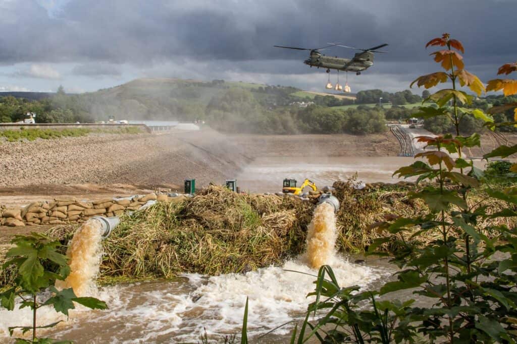
The point was made forcefully once before. Professor David Balmforth's independent review of the Toddbrook Reservoir incident at Whaley Bridge concluded that the auxiliary spillway failed on 1 August 2019 because of poor design, made worse by intermittent maintenance. His 14 recommendations included tightening how urgently inspection findings are worded. The structure had been compliant throughout. Reservoir flooding and canal breach are different hazards, but they share that lesson exactly.
Developers and homeowners should be aware of the risk of flooding to a property or site from a canal. Just because a canal has been there for a long time without incident doesn't mean there is no risk.
Emma Jeffery · Senior Flood Risk Consultant, Unda
Why canals are not mapped like rivers and the sea
Canals are largely absent from national flood mapping because the mapping was built around a different question. The Flood Map for Planning shows the probability of flooding from rivers and the sea, and sorts land into Flood Zones 1, 2 and 3 on that basis. The reservoir flood maps show the worst-case extent if a large raised reservoir were to fail, and both feed the postcode flood risk map a buyer or applicant is likely to check first. Neither covers a raised canal in between.
The asymmetry is legislative as much as technical. Of the Canal & River Trust's 84 reservoirs, 74 are large raised reservoirs regulated under the Reservoirs Act 1975, with statutory inspection by panel engineers and nationally published inundation mapping behind them. The embanked canal those reservoirs feed carries no equivalent statutory mapping duty. So the water body with the strongest regulatory regime is mapped, and the one running on an embankment through a village is not.
Something we see time and again is that many canals are not routinely modelled in the same way rivers and the sea are. That means the degree of flood risk from canals is often less well understood, even though the consequences of failure can be significant.
Emma Jeffery · Senior Flood Risk Consultant, Unda
A site can sit in Flood Zone 1, show nothing on the reservoir mapping, and still have a raised canal fifty metres uphill of it.
That is why the canal has to be picked up by the assessment rather than by the map. As Emma puts it: "Most canals don't show up as a source of flood risk on Environment Agency flood maps — but that doesn't mean a site isn't at risk. It often just means the canal hasn't been modelled in the same way as rivers or the sea."
What planning policy already requires
Planning policy has never limited flood risk to rivers and the sea, and it is explicit about artificial sources. The planning practice guidance states that areas at risk of flooding are those at risk from any source, now or in the future, and lists reservoirs, canals and lakes among them. That sits inside the wider NPPF flood risk framework.
It goes further on residual risk, the risk that remains once infrastructure and mitigation are taken into account. The guidance identifies two forms, one of which is residual risk from flood risk management infrastructure, giving a breach of a raised flood defence as its example, and requires an assessment to consider the consequences of infrastructure failing or its design standard being exceeded. None of that is reached by the sequential and exception tests, which sort sites by mapped probability and so say nothing about a canal.
Local evidence carries the same message. In Shropshire, canal breach risk is explicitly recognised in adopted planning evidence as residual flood risk, distinct from mapped fluvial or surface water flooding. The Shropshire Level 1 Strategic Flood Risk Assessment identifies canals as a potential source of flood risk where they sit elevated above surrounding land, and notes that failure can occur through overtopping, structural breach, or failure of associated infrastructure such as culverts, locks and weirs. For the Llangollen Canal west of Whitchurch it records two overtopping incidents within Shropshire, in 2009 and 2014, and five historic canal breach incidents, including a lock, sluice and weir failure at Hindford in 2007 and a culvert failure at Grindley Brook in 2014.
Any development proposed adjacent to a canal should include a detailed assessment of how a canal breach would impact the site, as part of a site-specific Flood Risk Assessment.
Shropshire Level 1 Strategic Flood Risk Assessment
There is also a consultee to satisfy. The Canal & River Trust is a statutory consultee under the Town and Country Planning (Development Management Procedure) (England) Order 2015 on development likely to affect any inland waterway or reservoir it owns or manages, or any canal feeder channel, watercourse, let off or culvert, within a consultation area it has notified to local planning authorities, a zone crossing 170 authority boundaries. That status was untouched by the government's statutory consultee reforms published on 17 August 2026, which removed the Gardens Trust and the Theatres Trust and narrowed Sport England's remit. It sits alongside the roles of the lead local flood authority, the local planning authority and the water and sewerage undertakers.
How to assess canal breach risk below a raised canal
Planning does not ask how likely a breach is. It asks whether the development is safe for its lifetime if one happens. That reframing is what turns an unmappable hazard into something an assessment can handle, and it produces a method rather than a probability.
- Establish the geometry. Survey the canal water level and the embankment crest against site levels to Ordnance Datum. The head between the canal and the ground below is what drives everything after it. Without it there is no assessment, only assertion.
- Identify the failure paths. Walk the length above the site and record the embankment height and construction where it is known, every culvert, lock, weir, overflow and feeder, and any point where the canal is in cutting rather than on embankment.
- Ask the asset owner. Condition information, inspection history, known leakage and any breach or overtopping record sit with the navigation authority, not in a public dataset. Ask early, because this is also the point at which the statutory consultee's expectations become visible.
- Model the breach scenario. Run the release as a scenario, not a return period: an assumed breach width at the most credible location, the volume the isolated pound would deliver before stop planks or paddles took effect, and the routing of that flow across the site. Where the consequence is material, that is a job for hydraulic flood modelling rather than a hand calculation.
- Design against consequence. Finished floor levels with freeboard above the modelled breach depth, layout that keeps the flow path clear of the more vulnerable uses under the vulnerability classification, safe access and egress that does not cross the flow, and a flood warning and evacuation plan where the residual depth or velocity warrants one.
- Say what you assumed. State the breach location, width, duration and the drawdown volume, and record the date and source of the asset information. A consultee can accept a conservative assumption that is written down; it cannot accept one it has to infer.
Is your site below a raised canal?
Our consultants assess canal breach and overtopping as part of a site-specific flood risk assessment, with a fixed-fee quote back within 60 minutes.
Get a quote in 60 minutesGuidance on development near canals is available from the Canal & River Trust, but Emma stresses that it has to be actively applied:
There is guidance out there on development near canals, but it has to be used properly and site-specifically. Relying on maps alone isn't enough.
Emma Jeffery · Senior Flood Risk Consultant, Unda
Ageing assets, a tapering grant, and a development's lifetime
A residential development is assessed over a 100-year design life. That is the horizon against which canal breach risk has to be judged, and over that horizon the funding picture is a material consideration rather than a background detail.
Defra's grant review confirmed over £400 million of funding for the Canal & River Trust across the ten years from 2027 to 2037, but with a fixed commitment that embeds a 5% a year downward taper across the decade, starting at £50.0 million and ending at £31.5 million in nominal terms, with a review point in 2032. Against that, the Trust's published condition data shows principal waterway assets in the lowest two grades rising to 14.20% at 31 March 2026. Its flood management assets, meaning culverts and embankments specifically, remain in far better shape at 0.51% in those grades against a 7% ceiling, which is a useful corrective to the assumption that every old embankment is a liability.
The right conclusion is not that canals are dangerous. It is that a real-terms funding reduction over exactly the period a new development will be occupied belongs in the reasoning, not in the optimism.
Climate is pushing the same way, as Emma notes:
With a changing climate and more intense and prolonged rainfall, we should expect greater pressure on canal embankments and structures. That makes understanding residual risk even more important.
Emma Jeffery · Senior Flood Risk Consultant, Unda
Where the Whitchurch repair stands
The Llangollen Canal is being rebuilt, with the Trust targeting reopening by the end of 2026. The scale of the work is a fair proxy for what a breach costs when it happens.
- Water removed. More than 15 million litres pumped out of the flooded field beside the breach.
- Sand cleared. Around 4,000 tonnes of sand removed from the site, and the field regraded.
- Wildlife recovered. More than 1,000 fish rescued from the flooded field, including eels, roach, perch, gudgeon, bream and ruffe, and relocated along the canal.
- Rebuild method. The embankment is being reconstructed in layers with polymer geogrid reinforcement, using imported granular material after testing showed the site's own material had too high a clay content to reuse; the channel itself is being rebuilt in concrete.
- Supply maintained. Around 40 million litres a day continues to be pumped around the breach, because the Llangollen Canal also carries raw water towards Hurleston for public supply.
That last point is worth holding onto. A canal is also a linear water-transfer asset running through settlements, so a failure interrupts more than boat traffic. The Trust's running repair log and its six-month progress report set out the programme in detail.
What the Whitchurch canal breach illustrates
The Whitchurch breach does not expose a gap in planning policy, nor does it point to a failure of regulation. With the cause now understood, it looks less like an oversight and more like the realisation of a risk the system already recognises but rarely sees so visibly: a slow, hidden process beneath an old structure that ends in sudden collapse.
Canal breach risk isn't theoretical. Events like this show why it needs to be considered carefully at the planning stage, particularly where people live or work below raised sections of canal. Without a detailed assessment of how a canal breach would impact a site, as part of a site-specific Flood Risk Assessment, the level of risk from failure, breach or overtopping simply isn't known.
Emma Jeffery · Senior Flood Risk Consultant, Unda
Canals are engineered structures embedded within the flood risk system, not passive features of the landscape. When they fail, the consequences are sudden, disruptive and highly visible. Those consequences are exactly what the planning system exists to anticipate and manage.
If you are considering development near a canal or another raised water body, our flood risk consultants can assess breach and overtopping risk as part of a site-specific flood risk assessment for planning, grounded in policy and technical evidence. The same work supports the wider flood risk assessment a lender, insurer or purchaser may need. Call 01293 214444 or email enquiries@unda.co.uk.
Frequently asked questions
Does a nearby canal affect my property or planning application?
It can. If a site sits below or beside a raised canal, canal breach risk should be considered as part of a site-specific Flood Risk Assessment, even when the canal does not appear on Environment Agency flood maps. For a development adjacent to a canal, planning authorities increasingly expect a breach scenario to be assessed rather than assumed away.
Who is responsible if a canal breach floods my property?
Liability rests with the navigation authority that owns and operates the canal, and is settled case by case rather than by any general rule. It is not the same question as riparian ownership, which governs natural watercourses. Ownership is not uniform: the Canal & River Trust holds most of the English and Welsh network, Scottish Canals holds the Scottish canals, and some waterways such as the Bridgewater Canal are privately owned. Where a breach floods land, the lead local flood authority may also publish a Section 19 flood investigation report, which is often the most useful public record of what happened.
How far below a canal does breach risk extend?
There is no standard stand-off distance, because the extent depends on the head between the canal and the ground, the volume the isolated pound holds, and the topography below. A low embankment across flat farmland behaves very differently from a high one above a valley side. The extent is an output of the breach scenario, which is why a distance rule of thumb will not satisfy a consultee.
Does a canal breach assessment always need hydraulic modelling?
Not always. Where the head is small, the site is well clear of the flow path and the proposed use is not vulnerable, a proportionate qualitative assessment with survey levels can be enough. Modelling earns its place where depths and velocities on the site actually determine the layout, the floor levels or the access strategy, or where an authority has already questioned an earlier submission.
Does living below a canal affect insurance or a mortgage?
Not usually on its own, because insurers price mainly from mapped river, sea and surface water risk, and canal breach is rarely in those datasets. The practical difficulty is the reverse one: a buyer can be reassured by a clean search and still be below an embankment nobody has assessed. A flood risk survey for a property purchase looks at every source, including artificial ones.
Are canal breaches becoming more common?
The published evidence does not show a clear upward trend, and the Trust's own incident count fell year on year to March 2026. What has changed is the pressure on the assets: heavier and more prolonged rainfall, a network largely built before 1830, and a grant settlement that reduces in real terms through the 2030s. That combination is a reason to assess the risk at a specific site, not a reason to assume the network is failing.
About the author. Emma is a Senior Flood Risk Consultant, and a policy and flood modelling expert. Unda has been trading since 2014, is a CIWEM Business Partner with CIWEM member and chartered (C.WEM MCIWEM) consultants, and has delivered 5,000+ flood risk assessments and drainage strategies across England and Wales.
Emma Jeffery · MSci (Hons)
Latest news






One of our experienced Flood Risk Consultants will get back to you within 60 minutes
