Floods in a Drought: Why Drought Causes Flooding in the UK
Estimated reading time 17 minutes
Floods in a drought sound like a contradiction. They are not. When soil has been baked hard for weeks it sheds rain rather than absorbing it, so one summer downpour can put water across roads and through doorways while rivers, reservoirs and groundwater sit at their lowest in decades. England spent August 2026 in exactly that position, with 71% of the country in drought and the Met Office warning of 40mm to 50mm of rain in two to three hours across the Midlands, the South East and much of Wales.
The flooding that follows a drought is almost always surface water flooding. It behaves nothing like the river flooding most people picture. It arrives in minutes, it happens well outside the mapped flood zones, and the drought measures that make the headlines, such as river gauges and reservoir stocks, carry on falling while it happens. For anyone bringing a site forward that combination is the point. The same ground can carry a real flood risk and a real water supply risk in the same year, which is why a surface water drainage strategy for planning now has to answer both.
England had its driest July since records began in 1836, with 6.5mm of rain against a long-term average of 65mm, and soil moisture deficit is now close to its highest level since 1961.
Why does drought cause flooding?
Drought causes flooding because dry ground loses its ability to take water in. Weeks without rain bake the surface, compact it, eliminate the vegetation cover that would otherwise intercept and delay run-off, and in certain organic and sandy soils generate a genuinely water-repellent surface film. Rain then arrives faster than the ground can accept it. The excess runs across the surface as overland flow, concentrating along the same drainage lines the topography has always dictated, and collects wherever the ground is lowest.
Hydrologists call this infiltration-excess overland flow, and it is the exact opposite of the mechanism most people associate with flooding, which is saturation-excess: the ground fills up over a wet winter until it can hold no more. People usually ask it the other way round: why it can flood after a drought. The answer is the same either way. The rain has nowhere to go, not that there is more of it. Winter floods happen because the ground is full. Summer floods in a drought happen because the ground has been dried past the point where its structure functions, so the limiting factor stops being available storage and becomes the rate at which the surface will accept anything at all.
- Infiltration capacity collapses. Infiltration capacity depends on soil structure and on antecedent moisture conditions. Prolonged drying closes the pore network that carries water downwards, so a soil that would normally take 20mm an hour may manage a small fraction of that.
- Soil becomes water-repellent. Organic compounds released as vegetation and microbes break down coat the soil particles in a waxy film. Rob Thompson of the University of Reading puts it simply: dry, cracked soils repel water rather than letting it soak in as wet soil would.
- Cracking cuts both ways. Shrinkage cracks in clay swallow the first few millimetres of rain quickly, then swell shut. Once they seal, the surface behaves as though it were paved, and the rest of the storm has nowhere to go.
- The vegetation that helps has gone. Grass burnt off in a heatwave stops intercepting rainfall and stops holding the soil surface open. Raindrop impact then seals the top layer instead.
None of this needs an unusual storm. A slow-moving convective cell dropping 30mm in an hour onto ground whose effective infiltration rate has fallen close to zero generates a run-off volume comparable to the same rainfall landing on an asphalt car park, which is why the flooding turns up in places with no recorded history of it.
What happens when the rain finally arrives
The sequence from downpour to flooded street takes minutes rather than hours, and that compression is what makes it dangerous: there is no gauge upstream showing a level rising slowly enough to watch, and no realistic interval in which a warning reaches the people standing in the way of it. Nobody gets an afternoon's notice.
- Rainfall intensity overtakes infiltration. Within the first few minutes the ground stops accepting water at the rate it is falling, and a film begins to move across the surface.
- Run-off concentrates in the natural low points. Overland flow follows the topography, gathering in the same hollows, back lanes and underpasses every time, whether or not those places appear on a national flood map.
- The drainage network fills. Gullies obstructed by a summer's accumulation of dust, desiccated vegetation and grit accept water more slowly, and the pipework downstream was sized against a conventional design storm rather than post-drought conditions.
- The system surcharges. Once the pipe is full, water backs up through gullies and manholes and rejoins the flow on the surface, adding to it rather than removing it. Everything past that point is exceedance flow, and it goes wherever the ground sends it.
- Depth builds where the flow is trapped. Sunken forecourts, basement lightwells, ramped car parks and any carriageway cut below the surrounding ground fill rapidly, because water arriving from a wide contributing catchment has nowhere onward to go.
Surface water is the most widespread source of flood risk in England, affecting about 4.55 million properties, roughly 72% of the 6.3 million at risk from any source and more than rivers and the sea combined.
The flooding is surface water, not rivers
Drought-driven flooding is pluvial flooding: rain that defeats the ground and the local drainage before it ever reaches a watercourse. Of all the recognised causes of flooding in England it is both the most widespread and the least visible on a flood map. That distinction explains the apparent paradox in the news. Reservoir stocks, river flows and aquifer levels are all integrated measurements, accumulated over weeks and months, against which a two-hour thunderstorm registers as statistical noise. The same storm can still put 300mm of water through a shop floor.
It also explains why the flood map is a poor guide during a drought. England's Flood Zones describe the annual probability of flooding from rivers and the sea, and nothing else, so a property can sit squarely in Flood Zone 1, satisfy every screening check a conveyancer or a validation officer runs, and still take surface water through the door in a dry summer. The national surface water layers help, but they are drawn at catchment scale. They show where water is likely to gather, not how deep it will be against a particular threshold, which is why surface water and planning so often come apart at the validation stage. Those national layers come from the Environment Agency's rebuilt national flood risk assessment, and the scale of the exposure is set out in our review of urban surface water flood risk in England. To see how a given postcode sits, our flood risk map reads the same national datasets.
Reservoir storage across England stood at 62.6% on 18 August 2026, 16.3% below average for the season, and a week later the Met Office was warning of up to 50mm of rain in three hours.
How dry is England in August 2026?
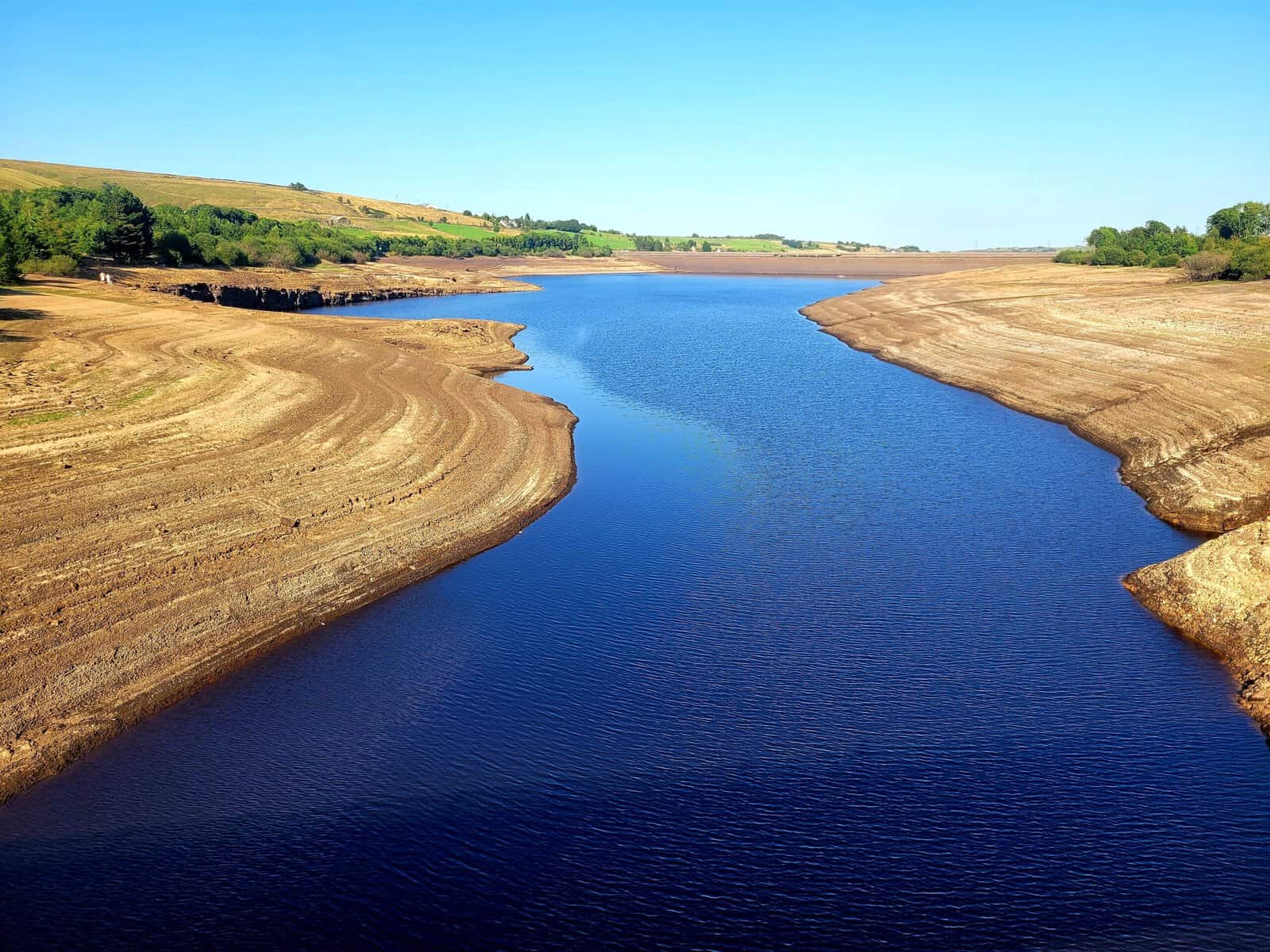
England is drier at this point in the year than it has been for decades, and that is precisely why the flash flood risk is raised rather than reduced. The figures below are taken from the Environment Agency's weekly drought reports and its monthly water situation summaries for England, and together they describe a hydrological position in which almost nothing that falls on the ground in the next fortnight will be absorbed by it.
- Drought coverage. 71% of England by land area was in drought on 20 August 2026, across ten areas, with a further four in prolonged dry weather.
- Rainfall. August rainfall to the 20th stood at 17% of the long-term average, ranging from 5% in the South East to 33% in the North West. July delivered 6.5mm, or 10% of average.
- Reservoirs. Storage across England was 62.6% on 18 August, 16.3% below average for the season, with seven reservoirs classed as exceptionally low.
- Rivers. A quarter of monitored sites were running exceptionally low for the time of year, concentrated in eastern, south-eastern and south-western England.
- Soils. Soil moisture deficit is nearing the highest recorded since 1961. On paper the soil column has more room for water than at almost any time in living memory. In practice it has lost the ability to use it.
With the ground conditions so dry, water does not easily soak into baked and compacted soils, increasing the risk of run off.
Environment Agency · Dry weather and drought in England: 14 to 20 August 2026
The Environment Agency has separately warned that England faces widespread drought in 2026 without a wet winter, which is the other half of the same problem: the rain that would refill the reservoirs has to arrive slowly enough for the ground to pass it downwards.
Drought to flood: a recurring UK pattern
Every significant English drought of the past fifty years has ended in rain the ground could not take, and several ended in flooding. The idea that droughts cause floods is not a projection about the future. It is a matter of record, old enough to be predictable and recent enough to be measured.
| Year | The drought | How it broke |
|---|---|---|
| 1976 | The most persistent drought in the modern record, running from May 1975 to August 1976 across southern England, with 35.9°C at Cheltenham on 3 July. | Ended abruptly in September and October 1976, with the autumn among the wettest on record. |
| 2012 | Drought orders in place across southern and eastern England in the spring after two dry winters. | April to July became the wettest on record for England, with widespread summer flooding, and the year finished as one of the wettest in a century. |
| 2022 | Drought declared across most of England in August after the hottest summer on record and the first 40°C day. | Thunderstorms in mid-August put flash floods across London and the South East within days of the drought declaration. |
| 2025 | Drought declared in north-west England on 29 May, unusually early and in one of the wettest parts of the country. | Summer storms produced surface water flooding while reservoir stocks were still falling. |
| 2026 | 71% of England in drought by 20 August after the driest July since 1836. | Met Office thunderstorm warnings on 26 and 27 August for 40mm to 50mm in two to three hours across England and Wales. |
What has changed is the frequency and the sharpness of the swing. Warmer air holds more moisture, so the rain that does fall increasingly falls in short, intense bursts, while the hotter and drier spells between those bursts desiccate the ground more thoroughly than they used to. We have looked at the trend itself in how increasing rainfall is changing UK flood risk, and at the modelling behind the swings in our piece on climate whiplash and UK river research. Both point the same way. Sharper extremes at both ends, arriving closer together.
What drought conditions mean for planning and drainage design
The planning system does not pause for a drought. Neither does the assessment work behind it. If anything, dry conditions expose the two assumptions that cost applicants the most time: that the ground will infiltrate, and that a site outside a flood zone has no flood risk to assess.
Infiltration testing is the clearest example. A percolation test carried out at the end of a record-dry August will return an infiltration rate that flatters the ground, because the soil is at its most desiccated, the shrinkage cracks are at their widest and the water table is at its seasonal minimum. Design a soakaway around that figure and it underperforms every winter of its life. The 2025 National Standards for Sustainable Drainage Systems, made mandatory through Policy F8 of the August 2026 NPPF, require ground conditions to be evidenced against a geotechnical investigation rather than assumed, and they set a minimum one-metre separation from the maximum likely groundwater level, not from the level a rig happened to find on the day. Our explainers on BRE Digest 365 testing for soakaway design and on checking geology and ground conditions for a soakaway set out what a defensible test looks like, and the BRE 365 infiltration rate calculator will work the figure through.
Policy F8 applies to development of any scale, so a single dwelling now needs a drainage strategy designed to the National Standards, and no longer only major schemes.
The flood risk side matters just as much. Policy F4 triggers a flood risk assessment for planning on the basis of risk from any source, now or in the future, which reaches sites in Flood Zone 1 that carry a surface water risk. Policy F7 sets a refusal test where a scheme cannot show it will be safe for its lifetime, and the planning practice guidance on flood risk and coastal change sets out how each test is applied. Where the only risk is surface water there is a narrow route around the sequential test, which we cover in our note on the surface water sequential test exemption. Neither test is satisfied by a paragraph observing that the site sits outside the mapped floodplain. Where drainage is the governing constraint, a properly evidenced drainage strategy for planning is what turns the assessment into a consentable scheme. The rules themselves are unpacked in our guide to the 2025 National SuDS Standards and where they stand in 2026.
Designing one site for two extremes
The useful conclusion from a drought that floods is that a site's water problem is not one problem. Across a hundred-year residential design life the same development will meet storms it has to hold back and summers it has to get through, and the two demands arrive in the same decades rather than in separate ones. A scheme designed for the average year handles neither.
Sustainable drainage happens to be good at both. That is a large part of why it has moved from a discretionary design nicety to a mandatory planning requirement applying to development of every scale. Storage that attenuates a storm peak is the same storage that holds water for reuse, and the National Standards put reuse at the top of the SuDS discharge hierarchy for that reason. Rainwater harvesting integrated into a drainage scheme reduces the discharge volume leaving the site during a storm and reduces potable mains demand during a dry period, a single intervention satisfying two independent constraints. Permeable surfaces, swales and detention basins do the same job more slowly across all four pillars of SuDS, and nature-based measures can extend the same logic across a catchment where the evidence supports it.
The design allowances point the same way. The Environment Agency's peak rainfall allowances, built on the Met Office's UKCP18 projections, require the upper end allowance plus an urban creep allowance for drainage designed to the 2025 standards. That is an explicit acknowledgement that the storms a scheme has to survive are getting heavier even as the summers get drier, and our guide to climate change allowances for planning sets out which epoch and percentile applies to which assessment.
A drainage design that only works when the ground is average is a design that fails twice: once in the flood, and once in the drought.
Frequently asked questions
Can it really flood during a drought?
Yes, and it is more likely, not less. Drought status is set by river flows, reservoir stocks and groundwater levels, all measured over months. Surface water flooding is set by whether one storm outpaces the ground and the drains, which takes minutes. The two indicators describe different parts of the hydrological cycle. An area can be formally in drought and flooded in the same week without any contradiction whatever.
Does dry ground cause flooding?
It does, and it is the reason flooding is more likely after a drought rather than less. Prolonged dry weather bakes the soil, compacts it and can leave it water-repellent, so rain runs off the surface instead of soaking in. The effect is strongest on bare or burnt-off ground and on heavy clay soils. It is weakest where vegetation cover has survived and organic matter keeps the soil structure open.
Is "floods in a drought" the same as climate whiplash?
It is one version of it. Climate whiplash, or hydroclimatic whiplash, describes rapid swings between wet and dry extremes in either direction. A flash flood at the end of a drought is the dry-to-wet swing. It is the more dangerous of the two, because the ground is least able to absorb rain at the moment the heaviest rain arrives.
How much rain does it take to end a drought?
Far more than a thunderstorm, and delivered far more slowly. A drought ends when river flows, reservoir stocks and groundwater levels recover. That needs sustained rainfall over weeks, usually through the autumn and winter recharge season, when evapotranspiration is low and the ground can pass water down to the aquifer. Intense summer rain largely runs off and leaves the deficit almost untouched. That is why a flash flood can happen without shifting the drought status at all.
How long does dry ground stay water-repellent once the rain returns?
Usually days to weeks, depending on the soil and how much rain falls. Repellency degrades progressively as the soil profile rewets. Gentle prolonged rainfall therefore restores infiltration considerably faster than intense rainfall, which predominantly runs off before achieving any meaningful wetting of the profile. The practical consequence is that flash flood risk peaks during the first significant storms after a dry spell and falls away as the ground takes water again.
Does a drought change what a flood risk assessment or drainage strategy has to cover?
Not the requirements, but often the evidence. The assessment still has to address every flood source across the whole design life, so the questions are unchanged. What changes is how far site data gathered in drought conditions can be trusted. Infiltration rates, groundwater levels and watercourse levels measured in a record-dry August are not representative. An assessment that leans on them without qualification is one a lead local flood authority is entitled to reject.
Drought and flooding are not separate problems needing separate answers. They are two ends of the same volatility, and the sites that cope with both are the ones where the water strategy was designed for the range rather than the average. Unda's flood risk assessments for planning and surface water drainage strategies are built around every flood source and the full design life of a scheme, in the climate a warming, whiplash-prone country actually has.
About the author. Charlotte is Unda's Marketing Manager, and is completing an MSc in Marketing at the London School of Economics. Unda has been trading since 2014, is a CIWEM Business Partner with CIWEM member and chartered (C.WEM MCIWEM) consultants, and has delivered 5,000+ flood risk assessments and drainage strategies across England and Wales.
Charlotte Stone · BSc (Hons)
Latest news






One of our experienced Flood Risk Consultants will get back to you within 60 minutes
