Jubilee River Flood Relief Channel: Route, Operation and Downstream Risk

Estimated reading time 20 minutes
The Jubilee River is an 11.6 km flood relief channel that takes water out of the River Thames at Taplow, carries it around Maidenhead, Windsor and Eton, and hands it back to the Thames between Eton and Datchet. It opened in 2002 and, according to the GOV.UK page for the scheme, protects around 3,000 properties. Because it moves floodwater from one stretch of river to another, the same question has followed the Jubilee River flood relief channel for more than twenty years: does it make flooding worse for the villages downstream?
On the Environment Agency's modelling, it does not raise flood levels downstream. It does not lower them either. Datchet, Wraysbury and Old Windsor still flood when the whole Thames catchment is full, because a relief channel moves water from one reach to another without taking any of it away.
Operating the channel makes "very little difference in the flows at Windsor, and the downstream water levels", the Government told Parliament in February 2024.
What is the Jubilee River and why was it built?
The Jubilee River flood relief channel is man-made but built to look like a natural river, and it is the centrepiece of the Maidenhead, Windsor and Eton flood alleviation scheme. It was built between the late 1990s and 2002 for about £110 million, and takes its name from the Queen's Golden Jubilee, the year it opened. Its one job is to lower Thames flood levels through Maidenhead, Windsor and Eton by taking part of the river's flow around them.
The towns needed it. The River Thames floodplain between Maidenhead and Datchet is wide, flat and heavily built on, and its flood record goes back a long way: one village downstream still requires new buildings to sit nine inches above the level reached in the 1947 flood. The scheme also includes embankments, flood walls and a flow control structure at Cookham and north Maidenhead. For anyone planning to build on this stretch, the channel is part of the flood picture, and a flood risk assessment for planning between Maidenhead and Datchet has to deal with it explicitly.
GOV.UK is careful about what the scheme was not built to do. It states that the Jubilee "is not designed to reduce flood risk to communities upstream or downstream of the scheme". That sentence sets the terms for the downstream debate further down this page.
| Feature | Detail |
|---|---|
| Opened | 2002, the year of the Queen's Golden Jubilee |
| Scheme | Maidenhead, Windsor and Eton Flood Alleviation Scheme |
| Length | 11.6 km published (11.7 km measured on the map above) |
| Route | Leaves the Thames just upstream of Boulter's Lock, Taplow; rejoins it just below Black Potts, between Eton and Datchet |
| Control structures | Five weirs: Taplow, Marsh Lane, Manor Farm, Slough Road and Black Potts |
| Normal flow | About 10 m³/s, a "sweetening" flow that keeps the water fresh for wildlife |
| Maximum flow | 180 m³/s at Taplow Weir (the original design figure was 215 m³/s) |
| Protects | Around 3,000 properties in Maidenhead, Windsor, Eton and Cookham |
| Cost | About £110 million |
| First major test | January 2003, when weirs were damaged and banks eroded below design flow |
Where is the Jubilee River?
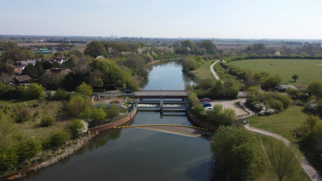
The Jubilee River runs along the north side of the Thames, from Taplow in Buckinghamshire to the edge of Datchet in Berkshire. It leaves the river just upstream of Boulter's Lock, passes Taplow, Dorney and Eton Wick, runs along the southern edge of Slough, and rejoins the Thames just below Black Potts, where the Windsor branch railway crosses. Measured on the map, the channel is 11.7 km long.
The Thames reach it bypasses, round the meanders past Bray, Boveney and Windsor, is about 14 km long, while the channel's two ends are only 9 km apart in a straight line. That is the whole idea. The channel gives flood flow a second, shorter route that avoids the built-up town reach altogether, and five weirs along it control how much water goes which way:
- Taplow Weir. The largest structure and the offtake. Its gates decide how much Thames flow is diverted into the channel.
- Marsh Lane Weir. The second control structure, near Marsh Lane between Taplow and Dorney.
- Manor Farm Weir. Mid-channel, east of Dorney and close to Dorney Lake.
- Slough Road Weir. At the A332 Slough Road bridge, between Eton and Slough.
- Black Potts Weir. The last structure before the outfall, beneath the Windsor branch railway viaduct.

How does the Jubilee flood relief channel work?
The Environment Agency runs the Jubilee in stages. In normal conditions about 10 m³/s flows down it to keep the water moving for wildlife. When the Thames reaches set trigger levels, the gates at Taplow Weir are opened in small steps, more of the river is sent round the towns, and the diverted water rejoins the Thames below Black Potts. The Agency's Jubilee Flood Relief Channel page shows whether the channel is operating, and its summary of operating procedures explains how each structure is used.

What happens during a Thames flood
- Duty officers track rainfall forecasts, river levels and hydraulic models for the Thames above Maidenhead.
- When the river passes its trigger levels, the gates at Taplow Weir are opened in small increments.
- Diverted flow builds in stages, drawing water away from the reach through Maidenhead, Windsor and Eton.
- The four weirs downstream hold levels along the channel until the flow rejoins the Thames below Black Potts.
At full operation the channel takes up to 180 m³/s at Taplow Weir, and the Agency gives a combined capacity for the Jubilee and the Thames of 450 m³/s, according to its 2023 press release on the Taplow Weir works. The highest combined flow recorded, in winter 2013–14, was 386 m³/s. The design figure disclosed at the public inquiry was 215 m³/s, a gap the Oxford Water Network records local campaigners still raising; an independent review by WS Atkins after the 2003 floods put the channel's real capacity at around two-thirds of that, which is why the two numbers still circulate side by side. Live readings from the Jubilee River level gauge at Taplow are published on the Check for flooding service.
Does the Jubilee River increase downstream flood risk?
No, on the evidence published so far. The Environment Agency modelled the Thames with and without the channel operating and found little change in flows at Windsor or in levels further down, and GOV.UK states that the scheme "does not adversely impact communities upstream or downstream". The Agency's position, set out in its answers to residents, is that downstream communities neither gain nor lose from it.
Communities downstream of the Jubilee do not benefit from it, but they are not at increased risk either.
Environment Agency, Maidenhead Windsor and Eton Flood Alleviation Scheme
The doubt comes from how the channel behaves. When it runs, part of the Thames flow skips the town reach and comes back in above Datchet. If that water rejoins while the river below is already high, people downstream can see Maidenhead's water arriving on top of their own, and the suspicion is understandable. The test is whether the combined peak at Datchet ends up higher than it would have been with every drop still in the main river. The modelling says it does not, because that water was always going to pass Datchet. The channel changes its route through Maidenhead and Windsor; it does not add to the total.
"No increase in risk" is a narrower promise than "no flooding": the villages downstream still flood from the Thames itself.
That gap between a modelled result and what happens on the ground is residual flood risk, and it is why the answer to the downstream question depends on what you mean by "increase". On a reach this complicated, site-specific flood modelling often tells a planning authority more than national mapping can, because it can test the channel running, not running and failing.
Did the Jubilee River cause the floods at Datchet, Wraysbury and Old Windsor?
The evidence says it did not. The Environment Agency puts the downstream flooding of winter 2013–14 down to prolonged rain over the whole Thames catchment falling on saturated ground. When Datchet's Parish Flood Team argued that the channel was the main cause of the 2002 flood, both the Agency and an independent assessment contradicted it, as set out in the Datchet case study on community and institutional flood knowledge. Residents in Wraysbury and on Ham Island still dispute that, and some said the channel raised the flooded Thames in February 2014.
In 2014 more than 1,000 properties flooded internally across the Environment Agency's Thames area. In January 2024 about 300 did, with a similar volume of water passing down the Jubilee.
Those figures come from a Government written answer to Parliament in February 2024, and they are the most useful evidence published since the channel opened. If the Jubilee were driving downstream flooding, similar volumes down the channel should have produced similar damage. They did not, which points to the size of the flood across the whole catchment as the thing that set the outcome.
None of this means local experience counts for nothing. The Parish Flood Team got the channel's share of the blame wrong, but its own records of how water moved through the village were valued enough that the group later became a partner in the wider Thames work. For a site in Datchet, Wraysbury or Old Windsor, the practical point is simpler: these are floodplain locations whose risk comes from the Thames itself, with or without the relief channel.
What went wrong in 2003, and how has the channel been maintained since?
The channel's first real flood, in January 2003, came barely a year after it opened and exposed faults. Weirs were damaged and the bed and banks eroded at flows well short of design capacity. Repairs cost about £3.5 million, and the Environment Agency recovered £2.75 million from the lead design consultants in an out-of-court settlement. Work on the weirs and banks has continued ever since.
| When | Work | Why it matters |
|---|---|---|
| 2003 onwards | Repairs and upgrades after the January 2003 flood, about £3.5 million | Weirs and banks failed below design flow in the channel's first real test |
| October to December 2020 | Channel shut; 56 m of steel sheet piles driven at Black Potts Weir | Erosion found in August 2020 threatened the weir and the railway bridge above it |
| February to April 2021 | New concrete apron and more than 2,800 tonnes of rock armour at Black Potts | The Environment Agency expects the repair to protect the weir for 60 to 100 years |
| Winter 2022–23 | £1.022 million gantry at Taplow Weir | Safer, quicker access to the sluice gates and stoplogs |
| 2025 to 2026 | Mechanical and electrical refurbishment of Taplow and Marsh Lane weirs | Keeps the gates that start every operation working |
| 2026 | Bank repairs downstream of Mill Lane Bridge, Taplow | Ongoing bank maintenance on the upper channel |


The 2020 closure matters most for planning. According to the Environment Agency's information sheet on the Black Potts repairs, the channel could not be used from October to December 2020 while the first phase was built; it went back into service just in time to carry the Thames high flows of late December. A defence that can be out of action for weeks is one whose absence a flood risk assessment has to plan for, which is the point made in the analysis of defences that are protected on paper but vulnerable in practice.
Is climate change making the Jubilee River run more often?
Yes. The Environment Agency says it is opening the channel more often because heavier and more frequent rain is producing more high flows on the Thames. The channel had already been opened more than 30 times by 2018, according to the Agency's residents' guide to the Jubilee River, and its Thames Area Director, Anna Burns, linked the rising frequency directly to climate change in a guest article on the scheme for Geography South West.
As the climate changes, we are seeing more frequent and more intense rainfall, resulting in more times when flooding occurs across the Thames Valley. This means we are having to operate the Jubilee more often.
Anna Burns, Thames Area Director, Environment Agency (December 2024)
More operation means more wear on gates and weirs, and more occasions when downstream villages see the channel running while their own river is high. For development, it strengthens the case for testing a site against the climate change allowances used in planning, not today's flood levels. The Environment Agency publishes the peak river flow allowances by management catchment, and a Thames site near the channel is assessed against the allowance for its vulnerability and lifetime.
Is the Jubilee River a conveyance or a storage scheme?
The Jubilee River is a conveyance scheme. It adds channel conveyance, meaning more capacity to move water quickly past a constrained urban reach, and it does nothing to reduce the total volume of floodwater coming down the Thames. Storage schemes work the other way, holding water back upstream in reservoirs or on farmland so that the peak arriving at a town is lower.
| Approach | What it does | Trade-off |
|---|---|---|
| Conveyance (the Jubilee River) | Adds a second route for flood flow, lowering peak levels at Maidenhead, Windsor and Eton | Total flood volume is unchanged; timing and distribution of flow downstream shift |
| Storage | Holds water upstream in reservoirs, washlands or on the floodplain to lower the peak | Needs large areas of land upstream; not what the Jubilee provides |
The distinction explains both what the Jubilee achieves and why people downstream stay watchful. Conveyance can cut the peak at a specific place by a measurable amount, which is exactly what Maidenhead and Windsor needed. It also changes when and where flow arrives further down the corridor. Upstream storage and natural flood management attack the volume instead, which is why most long-term Thames strategies combine the two.
How does the Jubilee River fit with the River Thames Scheme?
The Jubilee was meant as the first piece of a longer Thames strategy, not the finished article. Further downstream, the River Thames Scheme proposes two more relief channels, of about 4.8 km through Runnymede and 3.2 km through Spelthorne, plus weir improvements, to protect around 11,000 homes and 1,600 businesses between Egham and Teddington. As at September 2026 its Development Consent Order had still not been submitted, and no construction date had been published.
In a January 2026 appeal at Priory Stables, Shepperton, the inspector gave the unbuilt River Thames Scheme no weight at all.
That appeal was dismissed on the Sequential Test and on unsafe access, and it shows what the delay means for anyone relying on the scheme. Flood risk in a planning application is assessed on the defences that exist, so a site in Egham or Staines gets no credit for a channel that has not been built. The tidal Thames is a separate system again, protected by the Thames Barrier.
What does the Jubilee River mean for development along the Thames?
The Jubilee River lowers flood levels near many sites, but it does not change how those sites are assessed for planning. The Sequential Test is applied as if the channel were not there, the Flood Map for Planning shows Flood Zones ignoring it, and a site-specific assessment still has to prove the development is safe if the channel is shut, overtopped or not opened in time. For a proposal that cannot show those things, the likely outcome is refusal.
The Flood Map for Planning is drawn without defences, so a home the Jubilee River protects can still sit in Flood Zone 3.
- The Sequential Test ignores the channel. Planning Practice Guidance says that for the Sequential Test "the presence of existing flood risk management infrastructure should be ignored, as the long-term funding, maintenance and renewal of this infrastructure is uncertain" (Reference ID 7-024-20220825). A plot behind the Jubilee in Flood Zone 3a is weighed against other sites as if the channel did not exist. If a reasonably available site at lower risk exists, the application fails the Sequential and Exception Tests and should be refused, however well the channel performs.
- Residual risk has to be designed for. The 2020 Black Potts closure shows the channel can be unavailable for weeks. An assessment has to test that scenario, and set finished floor levels above the design flood level with the relevant climate change allowance added.
- Unsafe access can sink a scheme on its own. The Shepperton appeal turned partly on access classed as "Danger for Most". A flood warning and evacuation plan helps a borderline site; it does not rescue a route that floods too deep and too fast.
- Functional floodplain allows almost nothing. Land in Flood Zone 3b is limited to water-compatible uses and essential infrastructure. New homes there are refused whatever the channel does.
- A thin assessment draws an objection. The Environment Agency is a statutory consultee on most applications in Flood Zones 2 and 3, and an Environment Agency objection that goes unanswered usually ends in refusal or a long delay.
The safe way to approach a site between Maidenhead and Datchet, or downstream at Wraysbury, Old Windsor, Egham or Staines, is to start from the undefended position and then show what the Jubilee does for it, never the reverse. A River Thames flood risk assessment built that way answers the questions a case officer and the Environment Agency will ask. For local detail, see the area guides for Maidenhead and Windsor and Eton, or request a flood risk assessment for your planning application.
Frequently asked questions
Is my property at greater risk because it sits downstream of the Jubilee River?
Not because of the channel itself. The Environment Agency's modelling shows the Jubilee makes very little difference to downstream water levels, so a downstream property's risk comes from the Thames and the wider catchment. What matters for your property is its ground level, its distance from the river, and how the modelled flood level compares with your floor levels, which is what a site-specific assessment establishes. The Government's long-term flood risk service gives a first indication, and signing up for flood warnings costs nothing.
Does the Jubilee River protect against surface water and groundwater flooding?
No. It manages river (fluvial) flooding on the Thames only. Surface water and groundwater are separate sources that the channel does nothing to control, and on this stretch of the Thames valley groundwater in particular can be significant. A proper assessment looks at every source, and a groundwater flood risk assessment covers the one most often missed.
Is the Jubilee River a natural river or engineered infrastructure?
It is engineered infrastructure, built to look natural. A cut channel with gated weirs is hard engineering, but it was finished with meanders, shallow margins and reed beds, which is partly why it turns up so often as a GCSE geography case study. It is operated by the Environment Agency, controlled by five weirs, and has a repair history like any large asset. Treating it as a managed defence, not a permanent feature of the landscape, is the right starting point for any assessment.
Does being protected by the Jubilee River affect my flood insurance?
It can, but not always in the way owners expect. Insurers price on mapped flood risk and flood history more than on the presence of a defence, and because the Flood Map for Planning ignores defences, a home the Jubilee River protects can still sit in a mapped flood zone that a screening search will flag. An independent, property-level insurance flood risk assessment can show an underwriter how the modelled flood level compares with the building itself.
Can you walk, cycle or swim in the Jubilee River?
You can walk, cycle and ride beside it: a path runs the full length, including part of National Cycle Network Route 61, and sections close while the channel is operating. Swimming is prohibited. The channel has sudden drops of up to 5 m in places, and the weirs create dangerous currents even in normal flow.
About the author. Edward is a co-founder and Director of Unda with 20+ years in flood risk and drainage, and a national-press commentator on flooding. Unda has been trading since 2014, is a CIWEM Business Partner with CIWEM member and chartered (C.WEM MCIWEM) consultants, and has delivered 5,000+ flood risk assessments and drainage strategies across England and Wales.
Edward Bouët · BSc (Hons)
Latest news






One of our experienced Flood Risk Consultants will get back to you within 60 minutes
