Does Tree Planting Reduce Flood Risk? What the UK Evidence Actually Shows
Estimated reading time 18 minutes
Does tree planting reduce flood risk? Yes, but the size of the effect depends almost entirely on scale, and the honest answer changes depending on how far back you stand. Measure a woodland hillside against the grazed field next to it and the difference is dramatic. Model the same planting across a whole river basin and it nearly disappears. That gap between what works on a hillslope and what shows up at a gauging station is the part most coverage of trees and flooding leaves out. It is also the part that decides whether new woodland does anything useful for a particular site, which is a narrower and more awkward question than whether trees are good for rivers in general.
It also decides what a planning authority will accept. Upstream planting is a catchment measure, delivered by other landowners over decades, on a programme nobody applying for planning permission can influence or rely on. A development site is assessed on its own terms, which is why a scheme still needs a flood risk assessment for planning whatever the woodland cover looks like upstream.
Across twelve British catchments, every ten-percentage-point rise in woodland cover cut high flows by only about 1.3 per cent, and produced no consistent reduction in extreme floods at all.
How does planting trees reduce flooding?
Trees change how water moves through a catchment in five ways, and only two of them involve storing water. The canopy catches rain and evaporates part of it before it ever reaches the ground. Roots open up the soil so water soaks in rather than running off. Trunks, undergrowth and fallen wood slow whatever does run off. Roots hold banks together. And the trees themselves use water, drying the soil out between storms so there is more room in it when the next one arrives.
- Interception. The canopy holds rainfall and returns part of it to the atmosphere. The Woodland Trust puts canopy evaporation at up to 38 per cent of rainfall in large events, with broadleaves working hardest in summer when they are in full leaf. Interception is the mechanism most people picture, and the smallest of the five.
- Infiltration. Roots and the soil fauna that follow them create macropores, so rain soaks in instead of running overland. Infiltration is the largest single effect and the best evidenced.
- Roughness. Stems, undergrowth and deadwood drag on overland and in-channel flow, spreading the same volume of water over a longer period.
- Bank stability. Roots bind bank soils, which limits erosion and keeps channel capacity from silting up downstream.
- Soil drying. Trees transpire more than grass, so woodland soil starts a storm with more available storage. This is also why afforestation reduces river flows in dry weather.
None of that is controversial. Forest Research's synthesis of around 50 paired-catchment studies worldwide finds the same relationship between forest cover and peak flows, mostly for floods with a return period between one and ten years. What is contested is how much of it survives being scaled up. We work through the measure-by-measure picture in our analysis of what the Environment Agency's evidence directory says about natural flood management.
What the field evidence shows
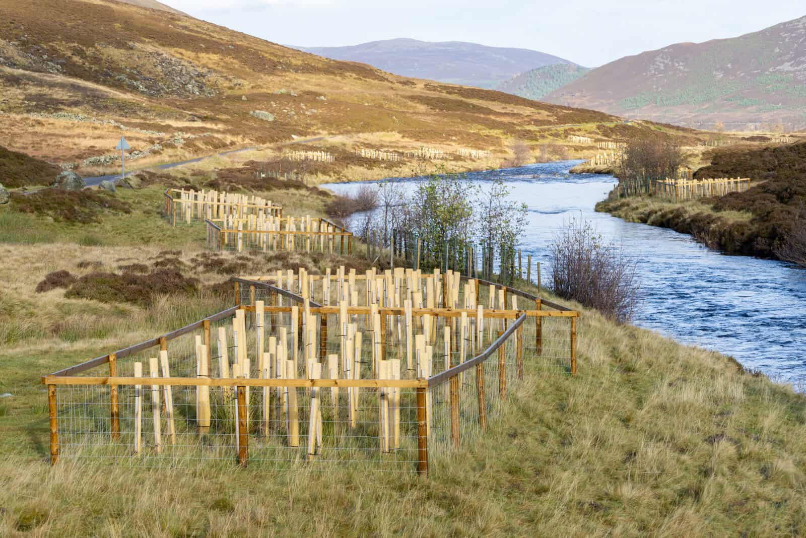
At plot and hillslope scale the measured effect of woodland is large, consistent and hard to argue with. Two British datasets carry most of the weight. Both compared trees against the grazed upland pasture that would otherwise occupy the ground, which is the comparison that matters, because the realistic alternative to a new upland woodland is almost never bare rock or tarmac but a sheep field with a compacted plough pan under it.
At RSPB Haweswater in Cumbria, a University of Leeds team led by Felicity Monger installed v-notch weirs and logged streamflow every five minutes for thirteen months, a period that included the wettest February in the UK record. Soils under mature broadleaf woodland were 11 to 20 times more permeable than soils under sheep-grazed pasture, and peak streamflow in the woodland streams ran up to 60 per cent lower than in the pasture streams. The difference held through Storms Ciara and Dennis rather than collapsing when the ground saturated.
At Pontbren in mid-Wales, infiltration measured inside tree shelterbelts was up to 60 times higher than in the adjoining grazed field. The trees were not planted for flood control; they were planted for shelter, and the hydrology came free.
| Study | What was compared | Headline result |
|---|---|---|
| RSPB Haweswater, University of Leeds (2022) | Mature broadleaf woodland against sheep-grazed pasture, 13 months of five-minute streamflow data | Soils 11–20 times more permeable; peak flows up to 60 per cent lower, holding through Storms Ciara and Dennis |
| Pontbren, mid-Wales (Carroll and others, 2004) | Tree shelterbelts against adjoining grazed pasture | Infiltration up to 60 times higher inside the shelterbelts |
| Forest Research natural capital assessment (2023) | UK woodland against grass, and against bare soil | Flood regulation worth about £420m a year against grass and £843m against bare soil, or £25.1bn over a century |
Those natural capital figures come from a Forest Research study jointly funded by the Forestry Commission, Scottish Forestry and the Welsh Government, and they are national totals rather than anything transferable to a site. The government's own summary of the benefits of woodland creation for water makes the same distinction between a national case and a site-level claim.
Soils under mature broadleaf woodland at Haweswater were 11 to 20 times more permeable than the sheep-grazed pasture beside them.
Why the effect shrinks as the catchment grows
Spread those hillslope results across a river basin and most of the benefit is lost in the arithmetic. The reason is arithmetic too. A catchment floods because water from a large area arrives at one place at the same time, and woodland only changes the behaviour of the ground it actually stands on, so its influence is roughly proportional to the share of the catchment it covers. In a large basin that share is small.
The most rigorous British test of this ran at the UK Centre for Ecology and Hydrology. Marcus Buechel, Louise Slater and Simon Dadson used the JULES land-surface model at one-kilometre resolution to run up to 288 broadleaf afforestation scenarios across twelve catchments between 511 and 9,931 square kilometres, and published the results in Communications Earth and Environment in 2022. For every ten percentage points of additional woodland cover, the top one and five per cent of flows fell by 1.3 and 1.4 per cent respectively. There was no nationally consistent reduction in extreme floods. Low flows, meanwhile, fell by 4.3 per cent, because the trees were using the water.
That last figure matters more than it looks. Widespread planting buys a small reduction in flood peaks and pays for it with a larger reduction in dry-weather river flow, which is the wrong direction of travel for a country that increasingly has to manage flood and drought risk together rather than one at a time.
The Environment Agency's Working with Natural Processes directory reaches the compatible conclusion from a different route. Reviewing around 800 studies across 17 measures, it finds catchment woodland effects are detectable where forest cover exceeds 15 to 20 per cent of the area and the catchment is under 100 square kilometres. Above that size, larger hydrological processes take over and the woodland signal fades.
The reading is not that planting is pointless. Woodland is a headwater and small-catchment measure. It works best on the frequent, moderate floods that cause most of the repeat damage, and it works alongside engineered storage rather than instead of it. That is also why the strongest British results, including the 15 to 20 per cent peak reduction at Pickering, come from small upland catchments with several measures layered together. Our survey of delivered natural flood management schemes sets out how those projects were assembled, and our explainers on leaky woody dams and beaver dams cover the measures that usually sit alongside the trees.
When does tree planting make flooding worse?
The disadvantages of planting trees to reduce flooding are real, and they are specific rather than vague. Badly sited or badly established woodland increases flood risk, and the official guidance says so plainly rather than burying it in a footnote. The Forestry Commission's own position, restated in August 2026, is that poorly planned and managed forestry raises flood risk through inappropriate drainage, road construction or harvesting that speeds run-off up rather than slowing it down.
- Cultivation and drainage at planting. The ploughing, mounding and drains used to establish a crop are an efficient run-off system. New forest drainage must discharge into a buffer area rather than straight into a watercourse, and the early years of a plantation can run wetter than the field it replaced.
- Floodplain woodland. Dense planting on a floodplain reduces conveyance. It attenuates moderate floods well, but it can raise local water levels, which is a problem if there is anything upstream of it.
- Riparian backing-up. In-channel attenuation is the point of riparian woodland, and it is also the risk. Put it in the wrong place and the water backs up onto someone else's land.
- Deadwood washout. Wood that leaves the reach in a big flood ends up against the first culvert or bridge downstream, which is a blockage mechanism rather than a storage one.
- Water yield. More woodland means less water in the river in dry weather. The effect shows at both catchment and local scale.
- Deep peat. Planting on deep peat damages a carbon store that is already saturated, so it buys little attenuation and costs a great deal. The Forestry Commission's sensitivity maps class deep peaty soils as high sensitivity for exactly this reason.
- Time. A plantation is not hydrologically mature for a decade or more, and the soil changes that do most of the work take longer still on thin upland ground. Nothing planted today changes a flood risk assessment submitted this year.
The UK Forestry Standard practice guide on riparian woodland is unusually direct about the trade-off, and it is worth quoting rather than paraphrasing.
Backing up of floodwaters because of the attenuation of in-stream flows is a potentially valuable contribution to natural flood management, but in the wrong place can increase the flooding of nearby upstream properties.
UK Forestry Standard Practice Guide · Creating and managing riparian woodland, Forest Research, 2024
Species choice carries its own risk. The guide recommends alder, birch and willow for riparian planting, but cautions against alder in acid-vulnerable catchments because it fixes nitrogen, and notes that Phytophthora alni already affects around 20 per cent of British alder. A buffer planted as a monoculture of a diseased species is not a durable flood measure.
Can upstream woodland help a planning application?
Not directly, and never as mitigation. Upstream planting is delivered by other landowners on a timescale nobody controls, its measured performance is specific to the catchment it was measured in, and it does not move a Flood Zone boundary. A lead local flood authority will not accept it in place of storage on the site, and the Environment Agency will not accept it in place of a finished floor level.
It counts as context, not mitigation. The August 2026 framework has made that context more visible. Nature-based solutions are now defined and required in national policy, and the surface water expectations under Policy F8 are unchanged by anything happening in the catchment upstream. We cover the detail in our note on nature-based solutions under the 2026 NPPF and the wider August 2026 NPPF changes.
- Greenfield run-off rates calculated conventionally, with no credit taken for upstream planting.
- Storage demonstrated in the hydraulic model, not assumed from a scheme's published percentage.
- Infiltration evidenced by BRE 365 testing where infiltration is proposed, not inferred from soil maps.
- Full climate change allowances applied, on the assumption that vegetated features underperform.
- A maintenance regime with a named, funded owner for the lifetime of the development.
On-site planting is a different matter. Trees inside a drainage scheme, in swales, rain gardens, basins and unsealed tree pits, are a legitimate part of a surface water drainage strategy and sit naturally within the SuDS hierarchy. That is the tree planting an authority will actually credit, and we cover the design end of it in our piece on green SuDS.
Woodland upstream, questions on your site?
Our chartered consultants will tell you what the catchment evidence supports and what your authority will actually accept. Free, no obligation, with a reply within 60 minutes.
Start a quoteWhat are the rules on planting near water?
Planting near a watercourse is regulated. The constraints are specific enough to design around, which is unusual and useful. The UK Forestry Standard sets minimum buffer widths between the forest edge and the water, and separate permitting applies close to a main river.
| Situation | Requirement | Source |
|---|---|---|
| Permanent watercourse under 2 m wide | 10 m buffer from the forest edge | UKFS Practice Guide, riparian woodland (2024) |
| Watercourse over 2 m wide, or a lake, reservoir, large pond or wetland | 20 m buffer | UKFS Practice Guide, riparian woodland (2024) |
| Abstraction point for a public or private water supply | 50 m buffer | UKFS Practice Guide, riparian woodland (2024) |
| Planting within 8 m of a main river, or 16 m of a tidal estuary | Environment Agency permit required | Forestry Commission, August 2026 |
| Forest drainage | Must discharge into a buffer area, never directly into a water body | UK Forestry Standard |
Whether a watercourse is a main river or an ordinary watercourse decides who regulates the work, and whether the consent is an Environment Agency flood risk activity permit or ordinary watercourse consent from the council. Anyone planting up their own bank is doing so as a riparian owner, with the duties that come with it. One more thing worth knowing before the trees arrive: the Forestry Commission's sensitivity maps, which screen land for woodland creation, carry no flood risk layer among their national datasets. Flood constraints are picked up case by case in consultation, not on the map.
Where has UK tree planting actually got to?
UK tree planting targets are being missed, and the gap is widening. Around 13,000 hectares of new woodland were created across the UK in 2025/26, according to the provisional statistics Forest Research published on 25 June 2026. That is down from 15,580 hectares the year before, and it is roughly a third of the 37,000 hectares a year the Climate Change Committee (CCC) said in its Seventh Carbon Budget the UK needs to reach by 2030.
UK new planting fell to about 13,000 hectares in 2025/26, from 15,580 the year before, against a Climate Change Committee target of 37,000 hectares a year by 2030.
The stock position tells the same story more slowly. UK woodland covered 3.29 million hectares at 31 March 2025, 14 per cent of the land area, against the roughly 16 per cent the Committee's pathway assumes by 2050. The distribution is uneven in a way that matters for flooding. Scotland is at 19 per cent and Wales at 15. England, where surface water risk and development pressure are both concentrated, sits at 10.
- Grant support is real and specific. The England Woodland Creation Offer pays up to £10,200 per hectare in capital costs and £400 per hectare a year in maintenance for fifteen years.
- Flood risk has its own line. Woodland that helps reduce flood risk attracts an additional £1,000 per hectare, and woodland improving water quality a further £500.
- The threshold is low. Applications start at one hectare, with a minimum woodland width of 20 metres, or 10 metres for a riparian buffer or shelterbelt.
- Timing is annual. Applications need to be in by 31 May to secure an agreement for the next planting season.
- The binding constraint is land, not money. Planting competes with farming and development for the same ground, which is the tension the England Land Use Framework exists to arbitrate.
Final figures for 2025/26 are due in Forestry Statistics 2026 on 22 October, so the provisional number may move a little when the full return is in. The direction will not.
What this means for a development site
The honest summary for anyone bringing a site forward is short. Catchment woodland is somebody else's long-term programme, and your site is assessed on its own. Planting upstream will not shift a Flood Zone, will not reduce a required storage volume, and will not satisfy the sequential test. Asked at the scale of a planning application, does tree planting reduce flood risk in any way an authority can bank? Not on its own. What it will do, over decades and at the right scale, is take some pressure off the frequent floods that cause the most repeat damage in small catchments.
On-site planting is the part worth pursuing. Trees inside the drainage design earn their keep twice, because they contribute to both the surface water scheme and, where the planting is designed for it, to biodiversity net gain. That is a design decision made at the drainage strategy stage, not a claim made in the flood risk chapter. It also sits alongside the other sources of flood risk a site has to address, most of which woodland does nothing for at all.
If you are working on a site where woodland, watercourses or catchment measures are part of the picture, our chartered consultants can tell you what the evidence supports and what an authority will actually accept. Talk to us about a flood risk assessment or drainage strategy on 01293 214444 or at enquiries@unda.co.uk.
Frequently asked questions
What are the downsides of afforestation for flood risk?
Three stand out. The drainage and cultivation used to establish woodland can raise run-off in the early years, planting on a floodplain or in a channel can back water up onto land upstream, and more woodland means less river flow in dry weather, which worsens drought exposure at exactly the time of year when a catchment can least afford it. There is also the wait. A plantation is not hydrologically mature for a decade or more.
Does existing woodland on my site change my flood risk assessment?
Not in the way people expect. Existing trees are already reflected in the modelled flood levels and in the greenfield run-off rate for the site, which makes them part of the baseline rather than a credit to be set against it. Removing them is what gets queried.
How long does new woodland take to make a hydrological difference?
Infiltration improves within a few years as roots and soil fauna open up the ground, but canopy interception and hydraulic roughness need a decade or more, and the fuller effect takes longer still on poor upland soils. Leaky structures and bunds installed alongside the trees work almost immediately, which is why schemes usually combine the two.
Do I need permission to plant trees along a river bank?
In England, planting within eight metres of a main river or sixteen metres of a tidal estuary needs an Environment Agency permit, applied for under the flood risk activity permitting rules. Away from a main river, work affecting an ordinary watercourse needs ordinary watercourse consent from the lead local flood authority or the internal drainage board. Felling licences and grant scheme conditions apply separately.
Can I count the same woodland for carbon, biodiversity net gain and flood risk?
The schemes are separate and each has its own rules on additionality, so assume nothing stacks until you have checked. Woodland can carry a Woodland Carbon Code project, contribute to biodiversity net gain and attract the England Woodland Creation Offer's flood risk contribution, but the eligibility conditions differ and some combinations are ruled out.
Is afforestation hard or soft engineering?
Soft. It works with natural processes rather than building a structure to hold water back, which is why it is grouped with river restoration, floodplain reconnection and leaky barriers rather than with walls, embankments and flood storage reservoirs. The classification also explains the limits. Soft measures do not provide a defined standard of protection.
About the author. Edward is a co-founder and Director of Unda with 20+ years in flood risk and drainage, and a national-press commentator on flooding. Unda has been trading since 2014, is a CIWEM Business Partner with CIWEM member and chartered (C.WEM MCIWEM) consultants, and has delivered 5,000+ flood risk assessments and drainage strategies across England and Wales.
Edward Bouët · BSc (Hons)
Latest news






One of our experienced Flood Risk Consultants will get back to you within 60 minutes