Construction stage flood risk: the gap between planning permission and practical completion
Estimated reading time 28 minutes
Construction stage flood risk is the flood risk a development creates, or is exposed to, between the day permission is granted and the day the scheme is finished. It is the phase in which temporary access roads cross watercourses, ground levels change in stages, and permanent drainage exists on a drawing rather than in the ground. Almost nothing in the English planning system tests it.
A flood risk assessment for planning models a finished scheme. It assumes final land levels, a completed drainage system and mitigation that works, which is how a flood risk assessment is normally scoped. Those assumptions are sound for the decades after completion and wrong for the eighteen months before it.
The Environmental Permitting Regulations catch "erecting any structure (whether temporary or permanent) in, over or under a main river". The law reaches temporary works even where planning policy does not.
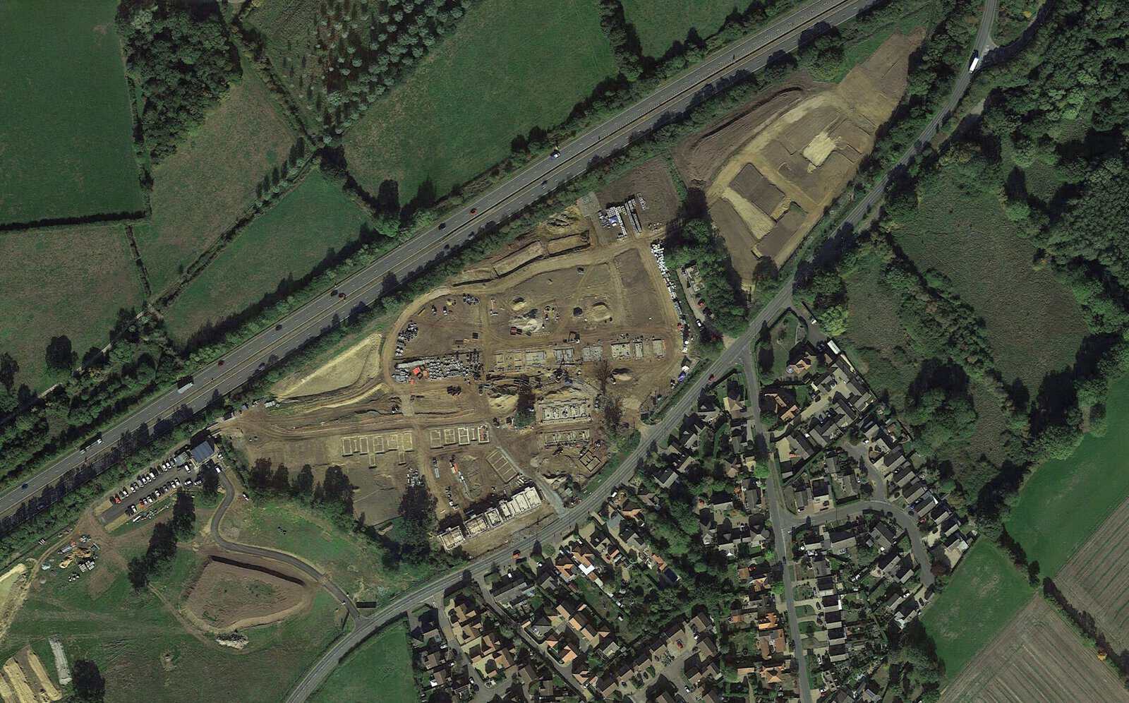
Attleborough in Norfolk is the case that made this concrete. Norfolk County Council's Section 19 investigation reported in January 2026. It found that a temporary construction road across the Besthorpe Stream "restricted the natural flow of floodwater along this stretch of the watercourse and contributed to the flooding of the affected properties". The road had no planning permission. Water backed up roughly 300 metres behind it. About 130 homes flooded.
This article sets out what the build phase does to flood risk and which controls actually apply once a site is live. It then works through what the Attleborough investigation found, and what a developer or contractor should have in place before breaking ground.
Why the planning system stops at the red line
Construction stage flood risk is unregulated because the planning system assesses two moments in a development's life and largely ignores the one in between. It tests the proposal. It tests the finished thing. The construction phase sits between the two, governed by conditions written for other purposes and by consents that many sites never realise apply to them.
Flood risk policy now sits in Chapter 18 of the National Planning Policy Framework published in August 2026, as Policies F1 to F9. Its tests are directed at the development and its lifetime: the sequential and exception tests, safe access and egress, climate change allowances, and no increase in flood risk elsewhere. Those are outcomes measured against a completed scheme. The Planning Practice Guidance on flood risk and coastal change was last updated in September 2025. It mentions the build phase once, at paragraph 7-011-20220825, where it notes that consideration can be given to "any additional land which may be needed temporarily during construction".
Planning application
Flood risk assessment, sequential and exception tests, drainage strategy, statutory consultee review.
Pre-commencement conditions
Construction environmental management plan, usually justified on ecology, dust, noise and hours.
Construction
Temporary crossings, phased land raising, part-built drainage, stockpiles, dewatering. Water consents still apply; planning policy does not reach it.
Completion and first use
Drainage conditions discharged, sustainable drainage details approved, adoption and maintenance agreed.
Occupation
Residual risk managed through flood warning, evacuation planning and asset maintenance.
Nor does the health and safety regime fill the gap. Regulation 13 of the Construction (Design and Management) Regulations 2015 requires the principal contractor to "plan, manage and monitor the construction phase", but CDM is a health and safety instrument. It captures water where water is a risk to people on site, in excavations and open channels. It says nothing about a site's works raising flood risk on someone else's land. That is not what CDM is for.
That leaves the construction phase covered by the planning process in name and by nobody in practice, whatever the residual risk the finished scheme was signed off against. Attleborough is what that looks like when a storm arrives at the wrong moment.
What the Attleborough Section 19 report actually found
Norfolk County Council investigated the flooding under Section 19 of the Flood and Water Management Act 2010 and published its findings as FIR076 Part 1. The report identified several causes acting together, and construction activity on the Norwich Road site was one of them. A county council spokesperson set out the range as "heavy rainfall and saturated ground conditions in October 2023, historic changes to watercourses linked to housing developments since the 1970s, local land and farming practices, and issues within the Norwich Road development site".
Storm Babet brought a period of intense and prolonged rainfall across large parts of Norfolk in October 2023. In Attleborough, the volume and duration of rainfall overwhelmed parts of the local drainage, sewerage, and watercourse network, resulting in floodwater entering residential streets and properties at speed and depth.
For many residents, the flooding was not a short-term inconvenience but a life-altering event involving contaminated water, rapid onset, and long displacement. Barry Herber, who has lived in Attleborough for more than 50 years, described how quickly conditions deteriorated:
"One minute it was OK, the next minute it just came in a torrent down the road."
Barry Herber · Attleborough resident
For households close to Mill Lane, flooding was compounded by sewer surcharge as drains backfilled under pressure. Geoff Freston recalled how internal flooding escalated as systems failed:
"They were pumping out people's houses into this road, the drains were backfilling, they were all overflowing. It was heartbreaking."
Geoff Freston · Attleborough resident
For the Herbers, the flooding brought both immediate danger and long-term harm. Barry Herber described being unable to reach home as water levels rose, and the moment he realised the severity of the situation:
"Ruth was here on her own when it happened. I had gone out, and I couldn't get home… That's the dogs screaming because they are floating around the house."
Barry Herber · Attleborough resident
The consequences extended well beyond property damage. Floodwater was contaminated with sewage, and the physical and psychological effects have been lasting. For many households, the flooding meant months away from home, repeated repairs, and a lasting sense of vulnerability. As one resident put it:
"Flooding is a fact of life for many of us now."
Attleborough resident
The site, and its planning history
At the time of Storm Babet, a major housing development was under construction on the north side of Norwich Road. The scheme, known as the Gables development, was planned to deliver 165 homes on land beside the Besthorpe Stream, an ordinary watercourse. Breckland Council refused planning permission in 2015 because the land lay within a floodplain. That decision was overturned on appeal in 2016, permission followed in 2018, and construction began in the summer of 2022.
The location matters. The site sits upstream of existing residential areas that later flooded, within a catchment already subject to known constraints and historic flood risk. The relationship between the site, the watercourse, and surrounding development meant that any change to flow conveyance or floodplain storage had the potential to affect neighbouring areas. Jesy Ferry, Flood Risk Consultant at Unda, explains why such locations demand heightened scrutiny:
"Developments closest to watercourses or in floodplains are inherently higher risk. This is why development is generally encouraged outside areas at risk of flooding, and why additional care is needed where that is not possible."
Jesy Ferry · Flood Risk Consultant, Unda
An appeal decision establishes that a scheme is acceptable in principle. It does not manage what happens on the site six years later.
How a temporary crossing changes a watercourse
The clearest mechanism behind construction stage flood risk is also the simplest. A temporary crossing reduces the cross-sectional area available to flow. Water backs up behind the restriction, and the backwater effect extends upstream for a distance set by the channel gradient and the size of the obstruction. Once the channel can no longer contain the level, flow leaves it and finds another route. Usually that is the road network, and the properties beside it. In Attleborough the investigation found water backed up around 300 metres.
Concerns about construction activity near the Besthorpe Stream were raised locally in the aftermath of the flooding, particularly about how quickly water levels rose and how little capacity appeared to remain within the channel. One resident questioned how such works had been allowed to proceed:
"This [road] was built without permission – why? That's the concern."
Attleborough resident
Subsequent investigation confirmed that a temporary road providing access to the development had been constructed across the Besthorpe Stream. During Storm Babet, that crossing held water back along the channel. After the floods, the East Harling Internal Drainage Board required the developer to clear the structure.
Three things make a temporary crossing more dangerous than the permanent structure it stands in for, and all three are products of the phase rather than the design.
- It is rarely modelled. Nobody has run the 1% annual exceedance probability event through the temporary arrangement, so its effect on upstream levels is unknown until a storm measures it.
- It traps what a designed structure passes. Granular fill, bagged aggregate and pipe crossings sized for site traffic catch debris that a properly sized culvert with a maintained screen would carry through. Sediment behaviour on a live site makes that worse.
- It arrives at the catchment's weakest moment. The permanent drainage is incomplete, attenuation storage is not yet built, and the ground is stripped, so there is less capacity elsewhere to absorb the difference.
Jesy notes that proximity to a watercourse changes the risk profile of the whole job:
"Projects closest to a watercourse, or in areas already known for surface water or groundwater flooding, will always be higher risk. Extra care is needed in these locations, regardless of how small that risk might appear at first."
Jesy Ferry · Flood Risk Consultant, Unda
In Attleborough this happened against a backdrop of already constrained infrastructure. Residents watched the result in real time, with floodwater spreading rapidly and overwhelming both surface water drainage and foul sewer systems. The critical issue is not that a structure existed. It is that the structure was introduced during construction, outside the configuration assessed at planning stage, at the point when the catchment was least resilient to additional restriction.
Which consents still bite once you are on site
The most expensive construction stage flood risk on most sites is a consent nobody applied for. Planning permission is not the only permission a site needs, and the water consents do not stop applying because a structure is described as temporary. Two regimes cover works in and around watercourses in England, and which one applies depends on how the watercourse is designated, not on the scale or the duration of the works.
| Ordinary watercourse | Main river | |
|---|---|---|
| Who regulates it | Lead local flood authority, or the internal drainage board in an IDB district | Environment Agency |
| What you need | Ordinary watercourse consent under section 23, Land Drainage Act 1991 | Flood risk activity permit under the Environmental Permitting Regulations 2016 |
| Does it catch temporary works | Yes. The statutory test is obstruction of flow, with no permanence qualifier | Yes, expressly — Schedule 25 reads "whether temporary or permanent" |
| What else triggers it | Culverting, altering a culvert, or any structure affecting flow within the channel | Works within 8m of a main river bank or defence (16m tidal), and excavation within 16m |
| If you do not have it | Notice under section 25; summary offence; the board may do the works and recover its costs | Operating a flood risk activity without the required permit is an offence |
For an ordinary watercourse, section 23 of the Land Drainage Act 1991 prohibits erecting "any mill dam, weir or other like obstruction to the flow" without the written consent of the drainage board concerned. The section contains no permanence qualifier, and lead local flood authorities apply it accordingly. Surrey County Council, for example, states that ordinary watercourse consent "covers works (including temporary works) that affect water flow within the cross-sectional area of the watercourse". It charges a separate fee for each temporary structure. Each one, not each site.
For a main river the position is more explicit still. Schedule 25 of the Environmental Permitting (England and Wales) Regulations 2016 catches "erecting any structure (whether temporary or permanent) in, over or under a main river". A flood risk activity permit is also needed for quarrying or excavation within 16 metres of a main river, and for anything that diverts or impounds flow. Check the designation on the flood risk map before you assume which regime applies.
The enforcement provisions reach the contractor as well as the landowner. Section 25 of the Land Drainage Act allows a notice to be served on "any person to whose act or default the condition of the watercourse… is due", and non-compliance is a summary offence. Where an internal drainage board is the relevant authority, as at Attleborough, it exercises those powers in place of the lead local flood authority.
Temporary works near a watercourse?
Our consultants will tell you which consent applies and get the assessment done before your programme slips.
Get a quote in 60 minutesWhy a CEMP is not a flood risk document
A construction environmental management plan is normally secured by a pre-commencement condition and normally justified on ecology, dust, noise and working hours. Flood risk during construction rarely features, because the condition that deals with drainage is timed to bite at a different moment altogether. That timing is where the gap opens.
The pattern is visible in real condition schedules. Take a 2025 planning appeal at Theale in West Berkshire. The council's suggested conditions required that "no development shall take place (including demolition, ground works, vegetation clearance) until a Construction Environmental Management Plan (CEMP) has been submitted to and approved in writing by the Local Planning Authority". The stated reason was biodiversity. Not water. On the same schedule, the sustainable drainage condition did not apply until the development was "brought into use".
One condition applies before work starts and does not cover water. The other covers water and does not apply until the work has finished. The build phase falls between them.
The Environmental Audit Committee reached a similar conclusion from the other direction. Its October 2025 report on flood resilience in England found that "Flood Risk Assessments are often limited in scope, applied on a site-by-site basis, and do not adequately capture cumulative or downstream impacts of development". It called for stronger compliance and enforcement, including "requirements for post-construction inspections to ensure mitigation measures are delivered in practice".
Capacity is part of the problem. Parliament heard as much during post-legislative scrutiny of the Flood and Water Management Act. The Merseyside flood risk partnership put it bluntly: "the process of discharging conditions is one that the LLFA is not funded or required to do and Local Planning Authorities lack the technical expertise to confidently discharge such conditions." That is the same constraint behind many LLFA objections, behind Environment Agency objections, and behind first attempts to discharge a drainage planning condition being refused. It is also why discharging conditions takes longer than most programmes allow.
Some lead local flood authorities have closed the gap themselves by asking for a construction surface water management plan as a document in its own right. Suffolk County Council's version is a useful model of scope.
- Construction drainage design. How runoff is collected, conveyed, treated and discharged while the permanent system is incomplete, sized for a real design event rather than for the dry months.
- Consents already obtained. Land Drainage Act consents and environmental permits listed, with reference numbers, before work starts rather than after a complaint.
- Flood risk controls. What protects the site and, more importantly, what protects everyone downstream and upstream of it.
- Pollution, water quality and emergency measures. Silt management, dewatering discharge and what happens when a control fails at two in the morning. The pollution prevention guidance for businesses sets the floor, and first flush is when it matters most.
- A phasing plan. The order in which levels change, storage is excavated and drainage is commissioned, with the interim condition assessed at each step.
- A site plan. Compounds, material storage and temporary parking located against the flood extent, not against the fence line.
- Maintenance and remediation schedules. Who inspects the temporary system, how often, and what triggers intervention.
Jesy's view is that the document matters less than the scope of the assessment behind it:
"The flood risk assessment should incorporate both permanent and temporary works, so the implications of flooding are understood across the full lifetime of the development, not just at completion."
Jesy Ferry · Flood Risk Consultant, Unda
And on the habit of treating the build phase as a footnote:
"Temporary works should not be concealed or treated as a secondary consideration separate from initial planning documents. Even if they are short term, they can fundamentally change how water behaves on and around a site."
Jesy Ferry · Flood Risk Consultant, Unda
Published guidance has not kept pace either. CIRIA's C532, Control of water pollution from construction sites, remains the standard reference and was published in 2001. C768, Guidance on the construction of SuDS, followed in 2017 and deals with building sustainable drainage correctly rather than with how a site behaves hydraulically while it is being built.
Land raising and floodplain behaviour during a phased build
Land raising is where construction stage flood risk does its quietest damage. Land raised in stages behaves differently from land raised in a single controlled operation, and the interim condition is almost never assessed. A partly built platform can impound water against lower ground for an entire winter under an arrangement no assessment has ever considered, and a topographical survey taken at the start will not describe it.
The Gables development was being constructed on raised land on the northern side of Norwich Road. As floodwater spread across the area during Storm Babet, this raised ground altered natural flow paths and limited how far water could disperse across the floodplain. Investigators concluded that the higher elevation held water back against lower ground to the south, increasing flood depths and widening the extent of flooding affecting existing homes. The effect was described as water being "impounded" against the raised land.
Compensatory storage is designed as a finished state. It is delivered as a sequence, and the sequence is usually the wrong way round.
Level for level compensatory storage assumes the new storage is excavated and the fill then placed. In practice the fill has to go somewhere on day one and the storage excavation sits late in the programme, so for months the site holds the fill without the compensation. That is a phasing decision with hydraulic consequences. It belongs in the drainage strategy, not in a site manager's head.
The same logic applies to stockpiles. Spoil heaped along a boundary is a bund. Nobody designed it as one. Nobody assessed it as one. It will divert water all the same. Where the stakes justify it, site-specific hydraulic modelling of the interim condition is the only way to know.
The civil courts take this seriously even where the planning system does not. In Partakis-Stevens v Sihan, decided in the Technology and Construction Court in December 2022, a householder who raised ground levels with imported clay spoil was found liable in nuisance for flooding a neighbouring property. The court found the works had "fundamentally altered and destroyed the natural equilibrium and inherent capacity of the soils" to absorb and attenuate surface water runoff, and awarded damages of £59,500.
Multiple contributing factors, not a single cause
Construction stage flood risk was not the sole cause of flooding in Attleborough, and no honest account of the event would claim it was. Official statements and investigations have consistently emphasised that multiple factors combined to produce the outcome experienced during Storm Babet.
Those factors included the intensity and duration of rainfall, saturated ground conditions, historic alterations to watercourses, and existing constraints within the local drainage and sewerage network. Several sources of flooding acted at once. Fluvial flooding and sewer surcharge then combined, which is what made the internal flooding as severe as it was. Jesy stresses that looking beyond the red line matters as much as looking inside it:
"Considering upstream effects is just as important as downstream. What happens on one site can have consequences well beyond its boundary, especially in constrained catchments."
Jesy Ferry · Flood Risk Consultant, Unda
Barry Herber's experience illustrates that interaction starkly. Floodwater entering his home was contaminated with sewage, leading to serious health consequences. That is a wider problem wherever surface water, ordinary watercourses and combined sewers are interconnected. It is also why a site's surface water drainage strategy has to account for what the receiving network already carries.
Residents have framed the issue in catchment-wide terms rather than attributing blame to a single cause. As one explained:
"We need a long-term solution in Attleborough, not just to prevent this event but to look at the water management in the catchment."
Attleborough resident
Flood risk is cumulative, shaped by the interaction of development, infrastructure capacity, land management and extreme weather, rather than by any single failure in isolation. That is precisely why the construction phase matters: it is a temporary, unassessed change layered on top of a system already operating close to its limit.
Governance, responsibility and who carries the liability
Responsibility for flood risk assets is often unclear before a flood and contested after one. The construction phase adds a further layer, because the site is under a contractor's control rather than the eventual owner's. Attleborough shows both problems at once. George Freeman, the Conservative MP for Mid Norfolk, has highlighted a longstanding issue:
"As many are aware, the culvert and watercourse were divested to riparian ownership many years ago."
George Freeman MP · Mid Norfolk
That historic arrangement meant no single public body held clear long-term responsibility for maintaining or upgrading key structures. Riparian ownership put the duty on private individuals who had neither the money nor the machinery. When flooding occurred, that ambiguity complicated both the immediate response and the longer-term planning. Freeman acknowledged that interim measures were not a substitute for structural change:
"It's clear that that we need a proper long term strategic plan that addresses problem watercourse pinch points AND looks to better control the flow of water downstream during heavy rainfall events."
George Freeman MP · Mid Norfolk
Liability during construction is clearer than most developers assume. Three routes run in parallel, and none of them depends on a planning breach having been established first.
- Statutory. A drainage board or lead local flood authority can serve notice under section 25 of the Land Drainage Act on whoever caused the obstruction, and require the watercourse to be restored at that party's cost. For a main river, operating without a flood risk activity permit is an offence in itself.
- Planning. Unauthorised operational development is enforceable, and a condition can require remediation of a problem the site has caused. Enforcement is slow, but the record of it follows the site through to sale.
- Civil. A neighbour whose property floods can sue in nuisance without waiting for any regulator. Partakis-Stevens awarded £59,500 against a single householder; the exposure on a housing site with dozens of affected properties is of a different order. A 2022 Local Government Ombudsman decision shows the parallel route, where the Environment Agency confirmed that lowered land levels left by a developer contributed to highway flooding.
Freeman has argued for going further, linking local experience to national policy:
"We are building far too many houses in flood plains and not improving the drainage structures."
George Freeman MP · Mid Norfolk
He has also highlighted the strain placed on ageing sewerage networks as new development comes forward:
"The drains are being plugged into old Victorian drains."
George Freeman MP · Mid Norfolk
Planning permission establishes that a scheme is acceptable in principle. It does not guarantee that the surrounding infrastructure has capacity for the extra loading during construction or occupation. That is a question for the water and sewerage undertaker as much as for the planning authority. Freeman has pressed on how the system might encourage earlier investment:
"I am trying to ask the question of how do you get housebuilders to invest up front?"
George Freeman MP · Mid Norfolk
And has argued for stronger accountability where development contributes to flooding:
"It seems to me that the only way is to make them liable for flooding downstream when homes flood because of their developments."
George Freeman MP · Mid Norfolk
What has changed in Attleborough since
The immediate works were done, they helped, and they were funded by every party except the one the investigation implicated. Anglian Water became involved on an interim basis despite not holding long-term ownership of the affected assets. As Freeman explained:
"On a without prejudice basis… Anglian Water have agreed to have their contractors assess the trash screen and culvert and work up the design for a much safer, more effective replacement."
George Freeman MP · Mid Norfolk
He went on to confirm:
"All stakeholders will then jointly fund the improved screen and Anglian Water will install it."
George Freeman MP · Mid Norfolk
By October 2024, around 100 tonnes of silt and detritus had been removed from two culverts at a cost of roughly £35,000, within a wider drainage programme of about £100,000.
That work was funded jointly by Norfolk County Council, Breckland District Council, Attleborough Town Council and Anglian Water, and a new trash screen was installed to make future clearance easier. The culverts themselves are still privately owned. Residents recognised the benefit while remaining realistic about its limits:
"We are delighted at the work that has been done and are in a much better position going into this winter."
Attleborough resident
But added:
"We will remain at risk if there is extraordinary rainfall."
Attleborough resident
The longer-term measures have moved more slowly. A £150,000 natural flood management scheme, funded by Defra in February 2024 to work on the upper headwaters of the Besthorpe Stream, has stalled. There is no money to compensate the affected landowners. Development pressure has continued. In August 2026 a proposal for up to 110 homes south of Bickley Close in Besthorpe drew objections from Freeman and local councillors. They called the site "fundamentally unsuitable for development on this scale".
The national picture points the same way, and it is contested. Aviva's analysis, published in February 2026, found that one in nine new homes built in England between 2022 and 2024 sit in areas of medium or high flood risk. A decade earlier the figure was closer to one in twelve.
What to do before you break ground
Managing construction stage flood risk does not require a new document for its own sake. It means extending the assessment you already have to cover the period you are about to build in, and obtaining the consents that already apply to you. Seven steps cover most sites.
- Assess flood risk during construction as well as at completion. Model the site as it will exist at each stage of the programme, rather than the state it reaches at handover.
- Map every interaction with an ordinary watercourse or main river, and apply early. Crossings, outfalls, over-pumping, diversions and works within the byelaw margin. Ordinary watercourse consent has a two-month determination period; a permit takes longer.
- Design the temporary drainage properly. Size it for a real design event with an allowance for climate change, not for the season you expect to be in.
- Write the phasing into the drainage strategy. State the order in which levels change, storage is excavated and drainage is commissioned, and assess the interim condition at each step.
- Sequence compensatory storage ahead of the fill. Where the programme will not allow it, say so and provide temporary storage for the interim.
- Set a trigger-based site flood plan. Named responsible person, Environment Agency flood warnings as the trigger, and actions that can be completed in the lead time actually available. It is the construction equivalent of a flood warning and evacuation plan.
- Record the pre-construction baseline. Survey levels and channel cross-sections before you start. It is the only evidence that will answer a claim two winters later.
For residents, the consequences of getting this wrong are immediate and deeply personal. As one put it:
"We have lived with this fear for many years and it is not something that will ever go away."
Attleborough resident
From a professional perspective, flood events are also an opportunity to reflect and improve. Jesy notes:
"Every flood event gives us an opportunity to review the evidence and consider alternative approaches that could reduce flood risk, not just for a development itself but for surrounding communities as well."
Jesy Ferry · Flood Risk Consultant, Unda
For planning authorities, developers and technical advisors the lesson is the same. Construction stage flood risk does not stop being anyone's problem because planning permission has been granted. Temporary works need to be transparent, appropriately designed and properly scrutinised. As Jesy puts it:
"Even temporary works should be constructed to an appropriate standard, regardless of how short term they are. That transparency is essential so everyone understands what is being proposed and what the risks are during construction."
Jesy Ferry · Flood Risk Consultant, Unda
Building in or near a floodplain, with temporary works in the programme? Talk to us about a flood risk assessment that covers the construction phase, or a drainage strategy for your development that carries the phasing through to completion. Call +44 (0) 1293 214444 or email enquiries@unda.co.uk, and one of our consultants will come back to you within the hour. Attleborough shows what happens when the build phase is underestimated, and why it deserves far more attention than it traditionally receives.
Construction stage flood risk: frequently asked questions
Does construction stage flood risk apply on a Flood Zone 1 site?
Yes. Flood Zone 1 describes the probability of flooding from rivers and the sea, not from surface water, groundwater or a blocked ordinary watercourse. A site can sit wholly in Flood Zone 1 and still contain a stream that a temporary crossing will obstruct, and the Land Drainage Act consent applies regardless of flood zone. Sites of one hectare or more, or within a critical drainage area, need a flood risk assessment in Zone 1 in any case.
Can a council impose a new flood risk condition after construction has started?
Not by adding one to a live permission unilaterally. A local planning authority can serve a breach of condition notice, or an enforcement notice where a condition has been broken or unauthorised operational development has taken place. A revised scheme can then be agreed through a section 73 application. Separately, a drainage board or the Environment Agency can serve notice on works in a watercourse whatever the planning position, and those powers do not wait for the planning process.
Should a flood warning and evacuation plan cover the build period?
It should where the site is at risk during construction, and most plans do not. The version submitted with a planning application is written for the occupants of the finished development. A construction-phase plan needs different triggers, a different responsible person and different escape routes, because the roads, levels and refuges the finished plan relies on may not exist yet. Site accommodation and material storage are usually the exposed assets, and both are movable.
Who must be notified if a site floods during construction?
Report pollution or an incident affecting a watercourse to the Environment Agency on its 24-hour incident line. Tell the lead local flood authority or internal drainage board where an ordinary watercourse is involved, and the local planning authority where an approved scheme or condition has been departed from. Notify your insurer before a third party contacts you, and record levels, photographs and rainfall data the same day, because the evidence degrades within hours.
Do the same rules apply in Wales?
The consent regimes do. The Land Drainage Act 1991 and the Environmental Permitting Regulations both apply in Wales, with Natural Resources Wales in place of the Environment Agency for main rivers. Planning policy differs. Flood risk in Wales is assessed under TAN15 through a flood consequence assessment rather than under the NPPF, so the document you extend is a different one.
About the author. Jesy is a Flood Risk Consultant specialising in property purchase, insurance and due diligence. Unda has been trading since 2014, is a CIWEM Business Partner with CIWEM member and chartered (C.WEM MCIWEM) consultants, and has delivered 5,000+ flood risk assessments and drainage strategies across England and Wales.
Jesy Ferry · MSc, BSc (Hons), GradCIWEM
Latest news






One of our experienced Flood Risk Consultants will get back to you within 60 minutes
