25 Years On: The Legacy of the Lewes Floods
Estimated reading time 13 minutes
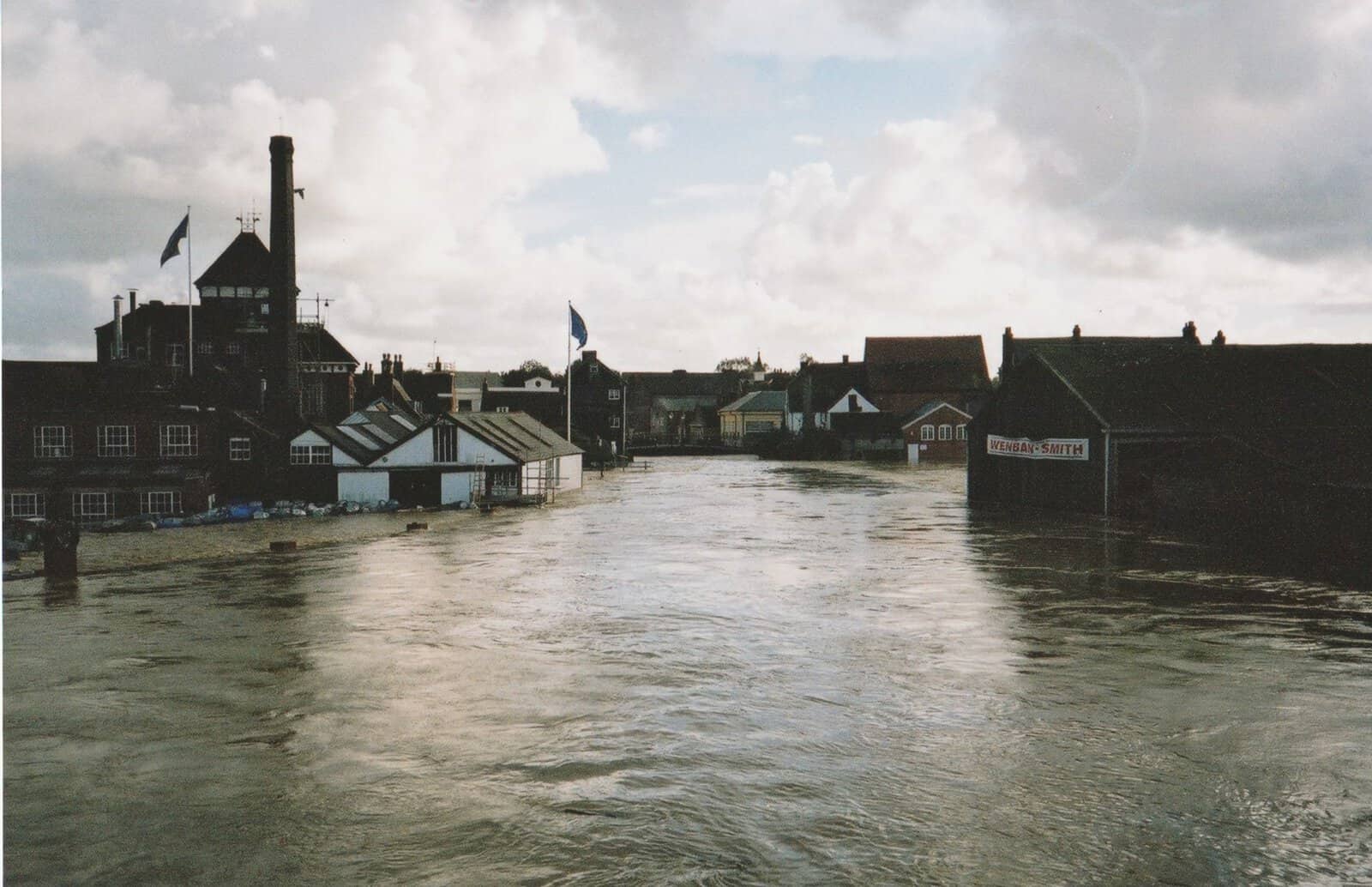
The Lewes floods of October 2000 were among the most severe England has seen in living memory. On 12 October 2000, after the wettest autumn on record, the River Ouse overwhelmed the town in a matter of hours, inundating 613 homes and 207 businesses, displacing more than 1,000 residents and causing an estimated £118 million of damage. Twenty-five years on, the event still shapes how flood risk is understood in Lewes and far beyond. It drove new defences, fed into national flood policy, and taught a generation of residents what it means to live beside a river.
This anniversary is a chance to look again at what caused the flood, the scale of what it did to the town, the long recovery, and how Lewes and the wider region have adapted since. Because the town still sits partly in Flood Zones 2 and 3, anyone buying, building or extending here typically still needs a site-specific flood risk assessment for planning. The story of 2000 is also a practical lesson in why.
Autumn 2000 was the wettest on record across England and Wales, and in Lewes it took only a single morning to turn the River Ouse from a familiar feature of the town into the cause of its worst modern disaster.
What caused the Lewes floods of 2000?
The Lewes floods were the product of a rare alignment of weather, geography and an overloaded river. Autumn 2000 was the wettest recorded across England and Wales, and by mid-October the ground was saturated and river levels were already high. When the remnants of an Atlantic storm system arrived, the catchment had nowhere left to put the water.
The rainfall figures were extraordinary. The Met Office recorded that 156.4 mm of rain fell at Plumpton in East Sussex over the 48 hours of 10–12 October. That is close to a month's rain in two days, on ground that could absorb none of it. Lewes sits in a narrow river valley ringed by the steep chalk slopes of the South Downs, so the runoff drained fast into the River Ouse. The channel, pinched by bridges and buildings as it threads through the town, could not carry the surge. The water overtopped the banks into the streets and low-lying properties around it.
On 12 October 2000 the River Ouse at Lewes reached its highest level on record, 4.935 metres, overtopping the town's defences.
This mix of fluvial flooding, constrained channel capacity and rapid hillside runoff is exactly the combination that makes historic valley towns so exposed. Understanding it is the starting point for any assessment of the town's risk today, and it is why the Environment Agency and the Met Office treat catchments like the Ouse as priorities for monitoring and forecasting.
Local resident Emma Webb recalls how quickly conditions changed:
"It caught everyone completely unaware. During the day we were watching the flooding in the town – we hadn't been able to go to work because the roads were flooded. We walked home to find flood waters creeping up towards our house."
Emma Webb · Lewes resident
The scale of the damage in Lewes
The flooding was without precedent for the town. 613 homes and 207 businesses were inundated, displacing more than 1,000 residents. Roads and rail links were submerged, schools were closed, and key infrastructure was damaged. The total cost of the damage was estimated at £118 million. Remarkably, there were no fatalities. The scale of the disaster was raised in Parliament that winter, as the town pressed for recovery funding.
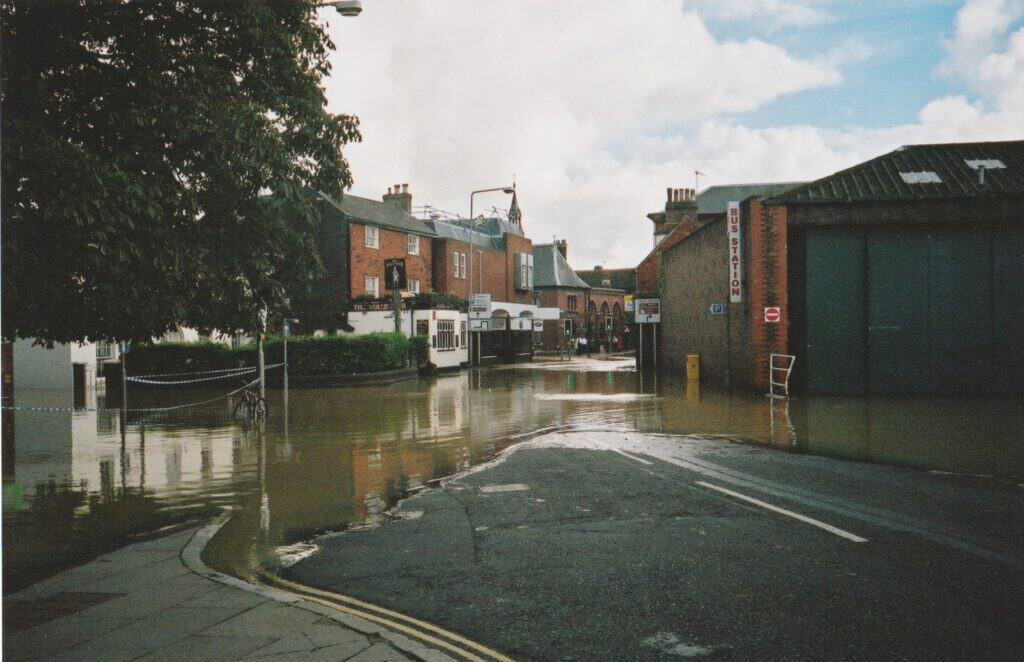
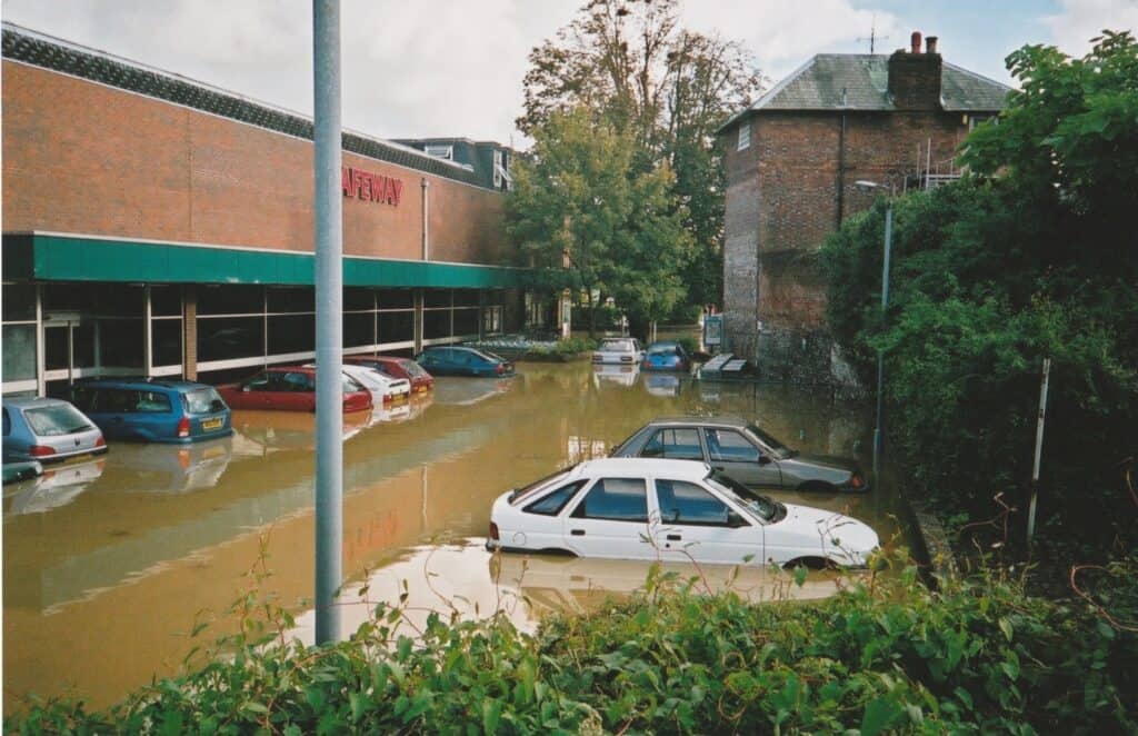
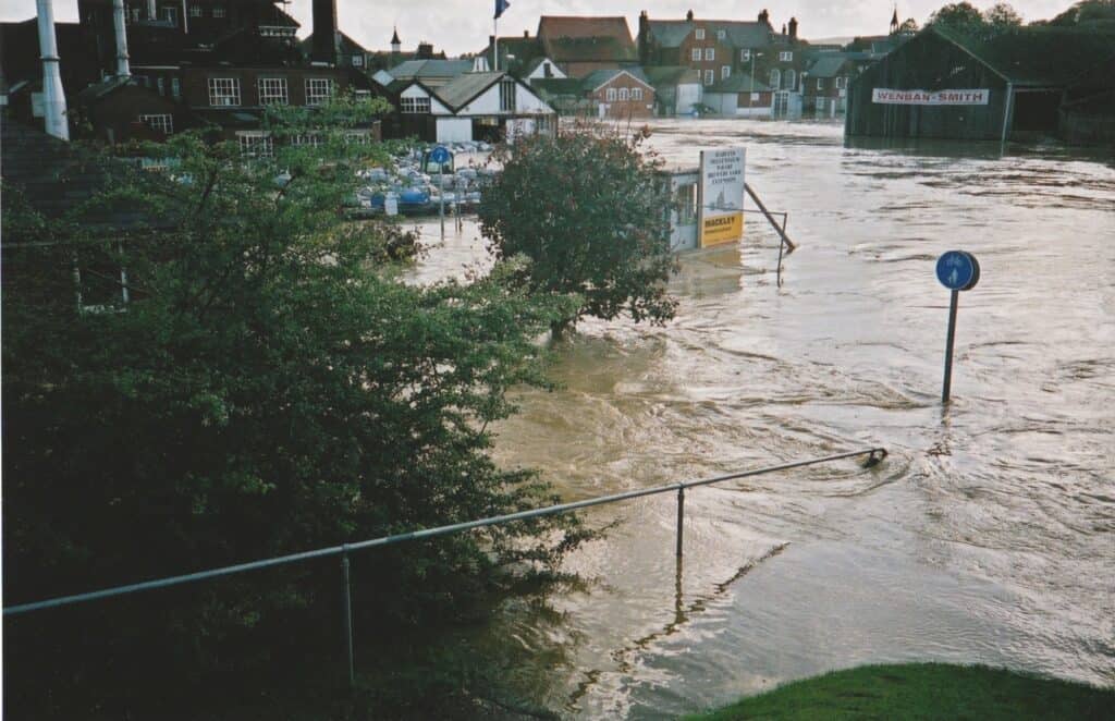
Beyond the physical damage, the floodwater itself was a health hazard. Pollution from sewage and chemical contaminants added to the destruction of homes, furniture and possessions. Emma remembers:
"The flood water was horrible and full of chemicals – we assumed it was from the neighbouring petrol station, but later learned it was chemicals from spilled barrels from the nearby industrial estate."
Emma Webb · Lewes resident
- Homes flooded: 613 properties inundated across the town.
- Businesses hit: 207 firms flooded, including premises along the riverside and in the centre.
- People displaced: more than 1,000 residents forced out of their homes.
- Estimated cost: around £118 million in damage.
- Lives lost: none, a rare mercy given the speed and scale of the flooding.
Uckfield and the wider Sussex floods of 2000
Lewes was not alone. The same run of storms flooded Uckfield upstream, where the fast-rising River Uck tore through the town centre in a flash flood, and the flooding reached Newhaven downstream as the Ouse turned tidal. Across Sussex, the autumn of 2000 became a shared benchmark against which later floods are still measured.
The Met Office recorded that the autumn 2000 floods affected around 10,000 homes and businesses at 700 locations across the country.
This was a national event. Unda's 25-year retrospective has followed it across the country: how York and the River Ouse in Yorkshire remember the floods of 2000, how the runways at Crawley and Gatwick went underwater, and how the Severn Valley learned resilience by repetition. Seen together, these events explain why 2000 was a turning point rather than just another bad winter: the sheer geographic spread forced the country to treat flooding as a systemic risk, not a run of local misfortunes.
The emergency response and recovery
With roads and rail links cut, power disrupted and hundreds of homes underwater, Lewes launched one of the largest civil rescue operations the county had seen. The East Sussex Fire and Rescue Service led the evacuation, deploying crews from across the county with additional support from neighbouring brigades. Firefighters used inflatable rescue boats to reach residents trapped in their homes, navigating narrow streets and strong currents in near-total darkness. Over 150 people were rescued by boat, many from upper floors or rooftops, as the water kept rising. Emergency rest centres were opened around the town for those displaced.
Emma describes the evacuation:
"We stayed in the house for as long as we could until the fire brigade ordered us to evacuate at about 5 or 6pm. The water had come up to our front door, but it was too dark to see its full severity. We waded out through the flood water and made our way to Malling Community Centre, which had been hastily opened up as an emergency rest centre as the flooding had cut off the other facilities, which were all on one side of the river."
Emma Webb · Lewes resident
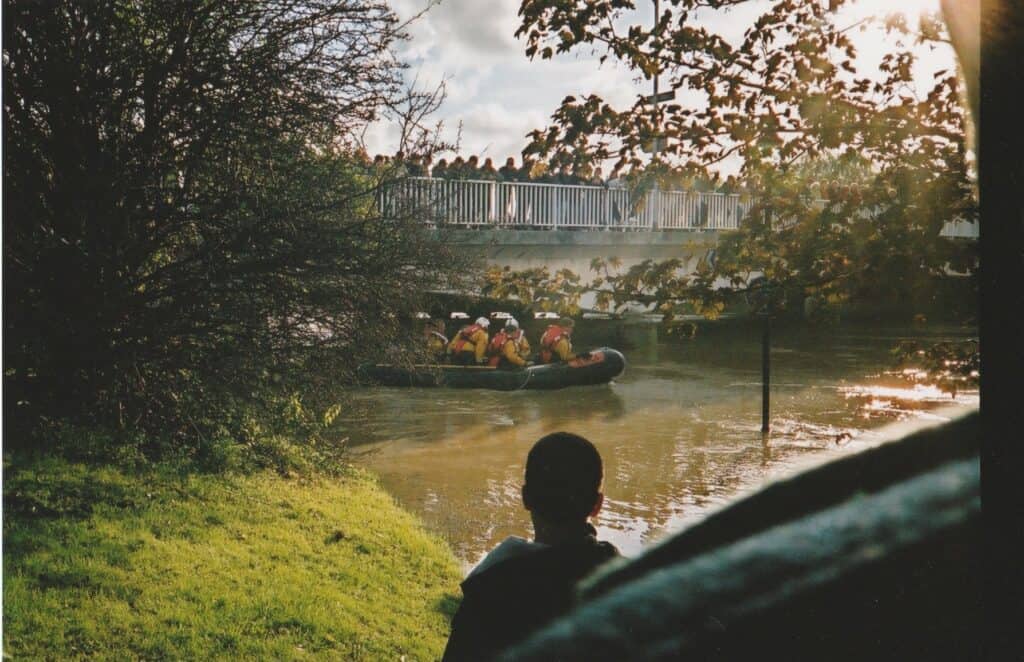
As the water receded, the effort turned from rescue to recovery. Streets were thick with polluted mud and debris. Homes and businesses had been left uninhabitable, and electricity and gas supplies stayed disconnected in many areas for safety. Some residents could not return home for weeks; others, for months.
The following morning, Emma returned to assess the damage:
"We walked home in the morning when it was light and the waters had receded enough to get into the house. We were thankful to find that the water hadn't entered the house, but as it was so cold and damp and there was no gas or electric, we stayed with friends and family until several days later when services were checked and turned back on."
Emma Webb · Lewes resident
The clean-up began almost at once. Lewes District Council, supported by the Environment Agency and emergency services, coordinated waste collection, road cleaning and the disposal of contaminated materials. Volunteers and local charities provided food, clothing and temporary accommodation. Even where floodwater had not fully entered a house, moisture seeped into walls, floors and foundations, causing hidden structural damage that only surfaced weeks later.
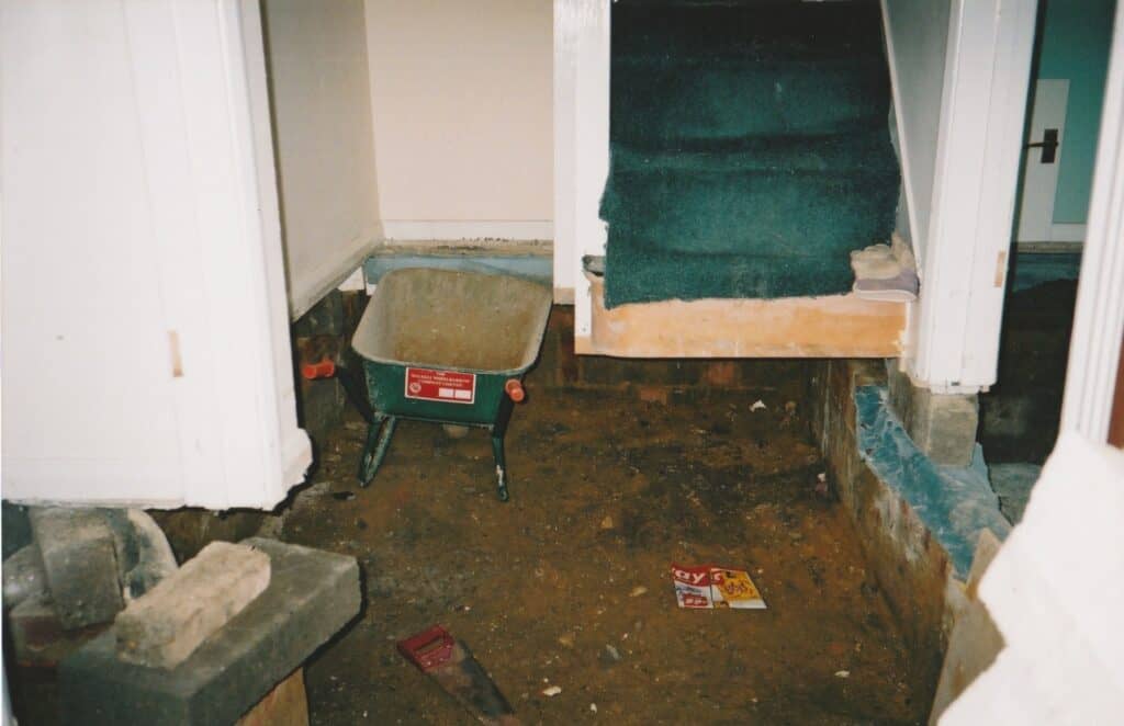
On discovering the damage inside their home, Emma says:
"Then we found cracks in the walls and shifted kitchen units and realised that the floodwaters had caused structural damage to the house. The concrete slab foundations had cracked in half and needed to be repaired. We moved out for 6 months while extensive repairs were done to the property"
Emma Webb · Lewes resident
Across the town the clean-up ran for months, with skips of ruined furniture, carpets and belongings lining the streets:
"It was so disruptive – the town was a mess for the next year with skips lining the streets full of people's belongings. It affected the town for a long time."
Emma Webb · Lewes resident
The disruption went well beyond the physical. The stress of lost homes and possessions, and the uncertainty over insurance and future safety, left lasting marks. That winter brought repeated flood alerts, each one reviving the anxiety of October:
"There were many more flood alerts that winter. We were living in fear of further flooding."
Emma Webb · Lewes resident
That unease became one of the most enduring legacies of the flood: a collective memory that still shapes how Lewes understands and lives with flood risk. It is the kind of lived experience that formal modelling can miss, a theme explored in Unda's work on the gap between community and institutional flood knowledge.
Rebuilding, resilience and what changed nationally
The Lewes floods prompted a rethink of flood risk management, locally and nationally. Authorities recognised that reactive responses alone were not enough against extreme weather sharpened by climate change.
The most immediate response was investment in defences. The Environment Agency, working with Lewes District Council, strengthened riverbanks, improved channel capacity and installed flood gates at key points, alongside smaller property-level resilience measures. The floods also drove better forecasting and warning: improvements in monitoring, river-level gauging and community alert systems now mean residents can be warned well before water reaches critical levels, whether by text, email or automated call. The Flood Forecasting Centre and the Environment Agency's warning service grew out of exactly this need.
- Stronger defences: reinforced riverbanks, improved channel capacity and flood gates through the town.
- Better warnings: real-time river gauging and text, email and phone alerts to at-risk homes.
- Community action: local flood groups formed to share information and coordinate volunteers.
- Property resilience: household-level measures to help homes withstand and recover from flooding.
At a national level, the floods fed into policy. They influenced the Environment Agency's approach and helped shape the Flood and Water Management Act 2010, the primary legislation that put sustainable drainage, risk assessment and shared responsibility between authorities, developers and communities at the centre of the system. The lessons carried well beyond Sussex. They fed later national reviews, including the Pitt Review into the 2007 floods, whose call for stronger coordination, better surface water management and clearer public communication still shapes government flood policy today.
For today's development, those principles are now routine: effective flood risk assessments, the Sequential and Exception Tests, sustainable drainage under the national SuDS standards and the careful discharge of drainage planning conditions all trace part of their logic back to events like Lewes.
Lewes flood risk today: living with the River Ouse
Lewes is safer than it was in 2000, but it is not safe from flooding, and that distinction matters. Much of the town still sits within Flood Zones 2 and 3 along the Ouse, and the Environment Agency's Flood Map for Planning shows river and sea risk regardless of the defences built since. A defended property can still fall in a high-risk zone, which is why a new scheme or purchase in Lewes usually still needs its own flood risk assessment.
Defences reduce flood risk; they never remove it. A property behind a flood wall can remain in Flood Zone 3 and can still flood in an extreme event.
Climate change is expected to make intense rainfall more frequent, so the pressures that overwhelmed the town in 2000 are, if anything, growing. Unda's analysis of climate whiplash and UK flood risk sets out that pattern. It is also why a home can sit in a flood zone even after new defences are built, a question Unda unpacks for anyone wondering why they are still in a flood zone. And the condition of a defence matters as much as its existence, which is the danger in relying on defences that are protected on paper but vulnerable in practice.
If you own, are buying, or are developing property in Lewes or along the Ouse, the practical steps are straightforward. You can check the broad picture with a flood risk map by postcode and watch conditions on the live river levels map or the Environment Agency's own check for flooding service, and sign up for flood warnings. For a planning application you will usually need a flood risk assessment for planning; if you are buying, a flood risk survey for a property purchase sets out the risk before you commit; and where cover is the concern, a flood risk assessment for insurance can support a better-informed policy.
As Lewes marks twenty-five years since the floods, its story remains a reminder of both vulnerability and progress. What happened in 2000 reshaped a town. Through stronger policy, smarter planning and local engagement, it also changed how the whole country thinks about living with water.
Frequently asked questions
Could the Lewes floods happen again?
Yes. The defences built since 2000 reduce the town's flood risk but cannot remove it, and climate change is expected to make the intense rainfall that caused the 2000 flood more frequent. Lewes remains exposed to fluvial flooding from the River Ouse, so residual risk and emergency preparedness still matter.
Is Lewes still at risk of flooding today?
Much of Lewes still falls within Flood Zones 2 and 3 along the River Ouse on the Environment Agency's Flood Map for Planning, which shows river and sea risk irrespective of defences. A property can be defended and still sit in a high-risk zone, so flood risk in the town is managed, not eliminated.
Do I need a flood risk assessment to build or extend a property in Lewes?
Usually, yes, if the site is in Flood Zone 2 or 3, is a hectare or larger in Flood Zone 1, or is shown at risk from surface water. English planning policy requires a site-specific flood risk assessment in these cases, and Lewes's position on the Ouse means many local sites qualify.
How can I check the flood risk for a specific address in Lewes?
Start with a flood risk map by postcode for the headline picture, then check live conditions on a live river levels map or the Environment Agency's check for flooding service. For a purchase or a planning application, a professional flood risk survey or assessment gives a site-specific answer the online maps cannot.
What flood defences protect Lewes now?
Since 2000 the Environment Agency and Lewes District Council have strengthened riverbanks, improved channel capacity and installed flood gates, backed by property-level resilience measures and a far better warning system. These reduce the likelihood and impact of flooding but leave a residual risk that assessment and planning still have to address.
About the author. Ellen is a Flood Risk and Drainage Consultant working across flood risk assessment and sustainable drainage design. Unda has been trading since 2014, is a CIWEM Business Partner with CIWEM member and chartered (C.WEM MCIWEM) consultants, and has delivered 5,000+ flood risk assessments and drainage strategies across England and Wales.
Ellen Webb · BSc (Hons), GradCIWEM
Latest news






One of our experienced Flood Risk Consultants will get back to you within 60 minutes
